All Activity
- Past hour
-
NW flow setups like that only work in areas from ATL on south if the upper level feature organizes much earlier across the TN Valley. This one developed too late and was too far north. The March 1980 storm was similar but the upper level low and trof developed much earlier and tracked more south.
-

February 2026 Medium/ Long Range Discussion: Buckle Up!
dailylurker replied to Weather Will's topic in Mid Atlantic
I did that the first week of January on the Tug. 100" in 4 days thank you lol. I'm hunting wintery conditions to last as long as possible. We do warm a safe roads 99.9% of the year. -
February 1 1931: A 'heat wave' develops across southern Minnesota. St. Peter hits 60. For Sunday, February 1, 2026 1893 - Thunder and lightning accompanied sleet and snow at Saint Louis MO during the evening hours, even though the temperature was just 13 degrees above zero. (The Weather Channel) 1951 - The greatest ice storm of record in the U.S. produced glaze up to four inches thick from Texas to Pennsylvania causing twenty-five deaths, 500 serious injuries, and 100 million dollars damage. Tennessee was hardest hit by the storm. Communications and utilities were interrupted for a week to ten days. (David Ludlum) 1951 - The temperature at Taylor Park Dam plunged to 60 degrees below zero, a record for the state of Colorado. (Sandra and TI Richard Sanders - 1987) 1985 - Snow, sleet and ice glazed southern Tennessee and northern sections of Louisiana, Mississippi and Alabama. The winter storm produced up to eleven inches of sleet and ice in Lauderdale County AL, one of the worst storms of record for the state. All streets in Florence AL were closed for the first time of record. (1st-2nd) (The Weather Channel) 1987 - A storm in the Pacific Northwest produced wind gusts to 100 mph at Cape Blanco OR, and up to six inches of rain in the northern coastal mountain ranges. (The National Weather Summary) (Storm Data) 1988 - Thirty cities in the eastern U.S. reported new record high temperatures for the date, including Richmond VA with a reading of 73 degrees. Thunderstorms in southern Louisiana deluged Basile with 12.34 inches of rain. Arctic cold gripped the north central U.S. Wolf Point MT reported a low of 32 degrees below zero. (The National Weather Summary) (Storm Data) 1989 - While arctic cold continued to invade the central U.S., fifty-four cities in the south central and eastern U.S. reported new record high temperatures for the date. Russell KS, the hot spot in the nation with a high of 84 degrees the previous day, reported a morning low of 12 above. Tioga ND reported a wind chill reading of 90 degrees below zero. (The National Weather Summary) 1990 - Thunderstorms associated with an upper level weather disturbance produced severe weather across the eastern half of Texas during the late afternoon and evening. Four persons were injured at Waco TX where thunderstorms produced wind gusts to 80 mph. Thunderstorms produced wind gusts to 97 mph at Cotulla TX injuring two other persons. Golf ball size hail was reported at Whitney and northeast of Whitsett. (The National Weather Summary) (Storm Data) 2011 - One of the most significant events of the 2010-2011 winter season affected a widespread region from Texas to the Midwest and Northeast from February 1st to 3rd 2011. The system produced widespread heavy snow with blizzard conditions and significant freezing rain and sleet to other locations. Snowfall amounts of 10 to 20 inches were common from northeast Oklahoma to lower Michigan. The storm produced 20.2 inches at Chicago, the third heaviest snowfall in the city since their records began in 1886, along with a peak wind of 61 mph. Kansas City received just under 9 inches of snow. The high temp was 17 degrees.
-
yeah, I could see that too - kind of like a 'glorified' arctic front.
-

Arctic Hounds Unleashed: Long Duration Late January Cold Snap
HoarfrostHubb replied to WxWatcher007's topic in New England
-2F for my daily low. Again, nothing earth shattering or unusual. Just the length of this cold spell. Impressive to me. -
That’s using 1951-1980 normals though…which is also the coldest 30 year period in winter for a chunk of NE in the last 100 years (gotta go back to earlier 20th century to beat it)….much easier to get BN on ‘91-20 normals.
-
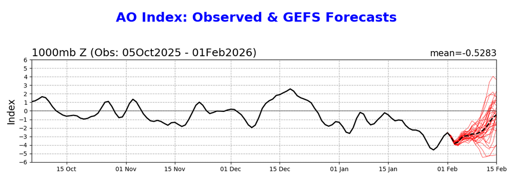
AO positive by late month?
-

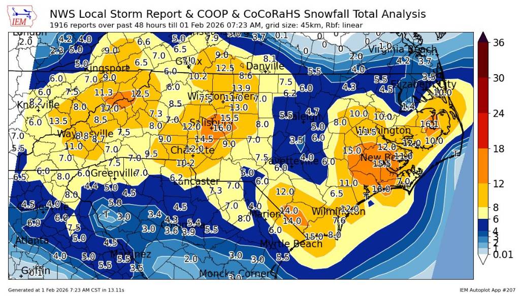
January 30th- Feb 1st ULL and coastal storm obs
Upstate Tiger replied to JoshM's topic in Southeastern States
Overall for the entire forum, the CMC and GFS seemed to remain the most consistent and verify the best. If I have time, I will try and go back and compare the globals from Monday to Friday. -
Was not expecting to see this steep spike in the AO! Perhaps we go positive for a while until the SSWE kicks in in March?

-
He’s crying in another thread too lol .
-
I will still watch for a little clipper or two over the next week or so. Nothing big but maybe a net gain. As Scott said, the moderation in temps could help us.
-

February 2026 Medium/ Long Range Discussion: Buckle Up!
winter_warlock replied to Weather Will's topic in Mid Atlantic
If ur worried about the mess made by snow maybe u need to move to Florida lol -
Well, it is the cliff diving discussion, which is meant for complaining. Growing up is my point. Thank you.
-

January 30th- Feb 1st ULL and coastal storm obs
UnionCountyNCWX replied to JoshM's topic in Southeastern States
For some areas sure. nam did the best in Raleigh and the dryslot aread. Euro wasnt showing the dryslot after it was already happening. -

Central PA Winter 25/26 Discussion and Obs
Superstorm replied to MAG5035's topic in Upstate New York/Pennsylvania
That’s better than 20:1. Nice fluff factor! . -
My method, though unplanned, worked well. Didn't shovel at all until the next day. Then methodically removed the ice crust in sheets with a hammer and my hands (no shovel). Then shoveled the soft, light snow underneath. Then moved on to next section of removing ice crust. Doing in sections kept exposed snow from hardening, and made a break possible. My back felt it, but could have been much worse. Caveat don't have a really long driveway thankfully. Ended up really glad I didn't shovel during the storm. Those who did had an easy final clean up but also worked during the storm so eh.
-

February 2026 Medium/ Long Range Discussion: Buckle Up!
MN Transplant replied to Weather Will's topic in Mid Atlantic
You are big dog hunting in the wrong place! -
Trust me I want that clippah to dig a bit and produce for us 100% but as Will said it looks paltry as of late and could be more of a Fropa with little accumulation. Let’s hope we can grab a few
-
(002).thumb.png.6e3d9d46bca5fe41aab7a74871dd8af8.png)
Central PA Winter 25/26 Discussion and Obs
ChescoWx replied to MAG5035's topic in Upstate New York/Pennsylvania
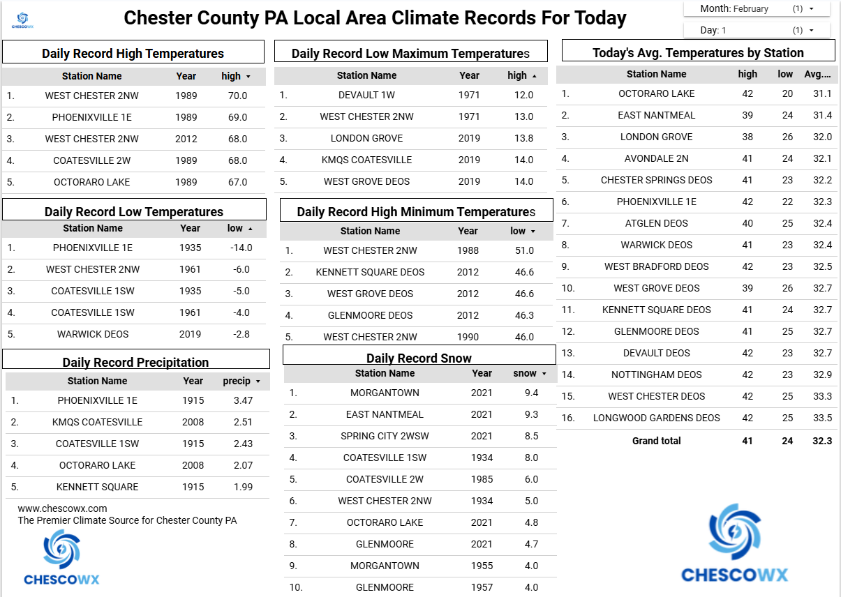
We start February as we ended January with well below normal temperatures. I am working on completing the overall Chester County summary for January but at least here in East Nantmeal this January was the 4th coldest and 3rd snowiest across the 23 years I have been recording weather observations at this location. This well below normal stretch of temperatures looks to continue for at least the first 10 days of February. Today will be our 9th straight day with below freezing high temperatures. We do moderate through Tuesday with our best shot at getting above freezing being Tuesday. The current NWS forecast has a high here in EN of 30 degrees. There could be a few light snow chances over the next week with the first potential on Tuesday night a more likely shot by Friday and another chance possibly by next Sunday. For those on Team Snow the good news is February is on average our snowiest month of the year with East Nantmeal averaging 13.3" of snow in a typical 2nd month of the year.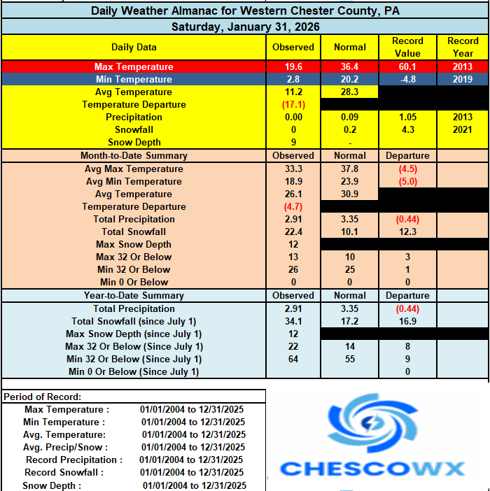

-
Heard this before…..
-
E PA/NJ/DE Winter 2025-26 Obs/Discussion
ChescoWx replied to LVblizzard's topic in Philadelphia Region
We start February as we ended January with well below normal temperatures. I am working on completing the overall Chester County summary for January but at least here in East Nantmeal this January was the 4th coldest and 3rd snowiest across the 23 years I have been recording weather observations at this location. This well below normal stretch of temperatures looks to continue for at least the first 10 days of February. Today will be our 9th straight day with below freezing high temperatures. We do moderate through Tuesday with our best shot at getting above freezing being Tuesday. The current NWS forecast has a high here in EN of 30 degrees. There could be a few light snow chances over the next week with the first potential on Tuesday night a more likely shot by Friday and another chance possibly by next Sunday. For those on Team Snow the good news is February is on average our snowiest month of the year with East Nantmeal averaging 13.3" of snow in a typical 2nd month of the year.
-
Yep, ended up the strung out piece of garbage with a kicker behind it we were expecting. Awesome that 4 flakes fell and there's cold dry wind.
-
We missed a KU event. If only this monster took a BM track. Painful miss.
-

Is we back? February discussion thread
Damage In Tolland replied to mahk_webstah's topic in New England
It’s very similar to one we had NYE/ NYD with a couple inches of snow in WAA and then maybe a heavy squall with front -

Central PA Winter 25/26 Discussion and Obs
Jns2183 replied to MAG5035's topic in Upstate New York/Pennsylvania
Imagine being in Raleigh? Sent from my SM-S731U using Tapatalk