All Activity
- Past hour
-
GEM has been better than the GFS of late. JB has posted this on Twitter, but I don't feel comfortable sharing the tweet or a screenshot because his post is somewhat unhinged.
-
Winch chills here in Bristol are 13F. Flurries are in the air. What a reversal in temps.
-
Eye candy .
-

Central PA Winter 25/26 Discussion and Obs
canderson replied to MAG5035's topic in Upstate New York/Pennsylvania
That didn’t take long. 52 mph winds. -
Yeah. I get it. Really do. But this is a la nina. Adjust expectations accordingly.
-
The GEM at 240 could be on to something. Southern Arkansas to Myrtle Beach. This is not far from where the EURO was 24 hrs. ago. Verification at this range is comparable to the GFS.
-
We usually get a big one once a decade and we’re nearing a decade since the last one.
-
I feel like many are chasing a 20”+ big dog and anything less is a rug (even something close to a 4-8er)
-

Ice Ice Baby December 28-29 Storm Discussion
dendrite replied to Baroclinic Zone's topic in New England
I drove up to Lyndon with my father during it to work on my shitbox 87 Cavalier that died in the LSC parking lot before break. I remember the Lakes Region looking like a disaster area from 93…mostly from about here through the woodstock area. We gradually lost ice through the notch until it looked like mostly just wet trees on the other side toward Cannon. -

Pittsburgh/Western PA WINTER ‘25/‘26
colonel717 replied to Burghblizz's topic in Upstate New York/Pennsylvania
Looks to be the case since it runs to Thursday morning. -
The 12z CMC has the EPO in place by Jan 6 with a nice pattern in place by the 8th - eastern trough.
-

E PA/NJ/DE Winter 2025-26 Obs/Discussion
Mikeymac5306 replied to LVblizzard's topic in Philadelphia Region
Not necessarily. GFS just misses the phase for the 8-9th storm while the CMC has a MECS at the end of its run. Long way away but defiantly something to keep an eye on. -

Pittsburgh/Western PA WINTER ‘25/‘26
Rd9108 replied to Burghblizz's topic in Upstate New York/Pennsylvania
Im guessing thats with the clipper? -
Dude. LFG! You can ride with me. We got extra room. Drive out and meet me at a park and ride around the md line. I'm not coming out there lol.
-
It's understandable to a point, we've been stuck in a nearly decade long pattern of fails and heart breaking last minute rug pulls. That being said, the hissy fits over a single op model run beyond HR240 not showing a Top 10 Miller A are exhausting.
-
Ice Ice Baby December 28-29 Storm Discussion
dendrite replied to Baroclinic Zone's topic in New England
If you don’t like the weather in New England just wait 5 months. -
I thought the 12z GFS was close with two storms on Jan 7 and Jan 11. Sure enough, the 12z CMC which doesn’t have a progressive bias…brought it. Good look. Big storm.
-
We just can’t know yet! I think the current monster storm in the Great Lakes needs to unwind before we understand where the pieces will fall. official: Patience required, but I think it’s coming! “Folks”
-
I don’t have much to add other than people much more knowledgeable than I were saying 2nd week of January was when things would get active. Not sure why people are freaking out. It sucks to waste a week but it is what it is. We’ve been in much worse situations at this time in the season, with zero snowfall.
-

Ice Ice Baby December 28-29 Storm Discussion
VivaManchVegas replied to Baroclinic Zone's topic in New England
The '98 ice storm was incredible. I remember driving up from Manchester to visit my parents in the Wolfeboro area on that Saturday. It was the first day it would get above freezing and from their back deck all you heard many trees cracking as the ice softened. The Ice acted like a support structure, until it didn't. -
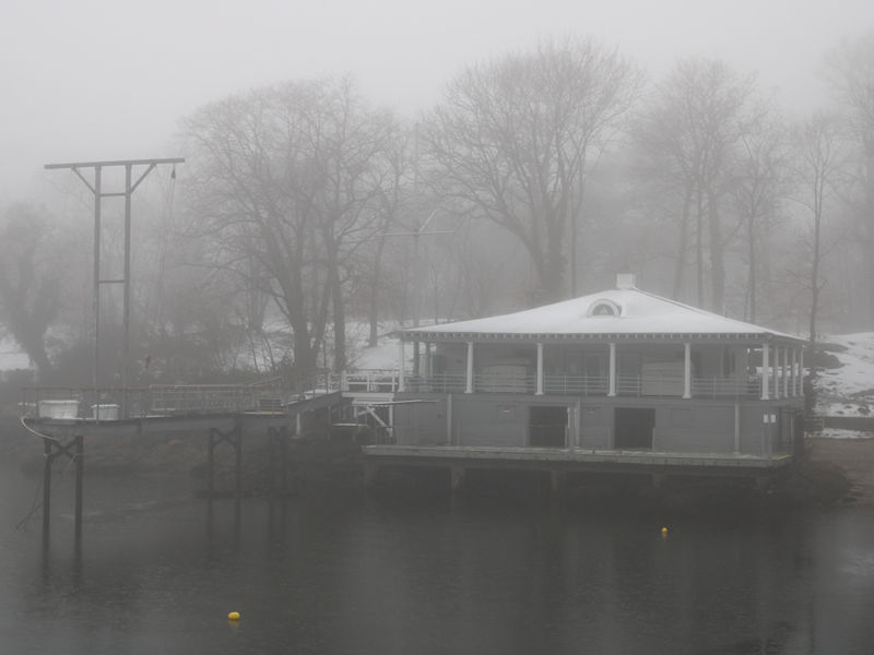
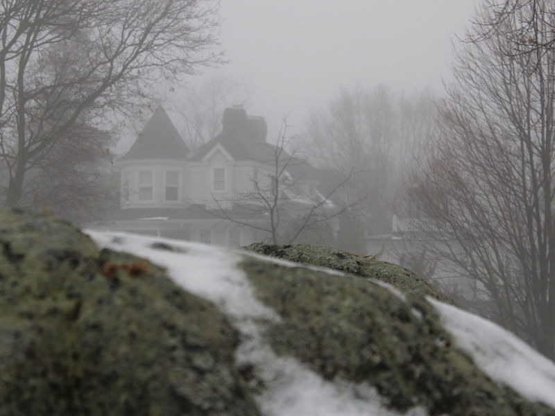
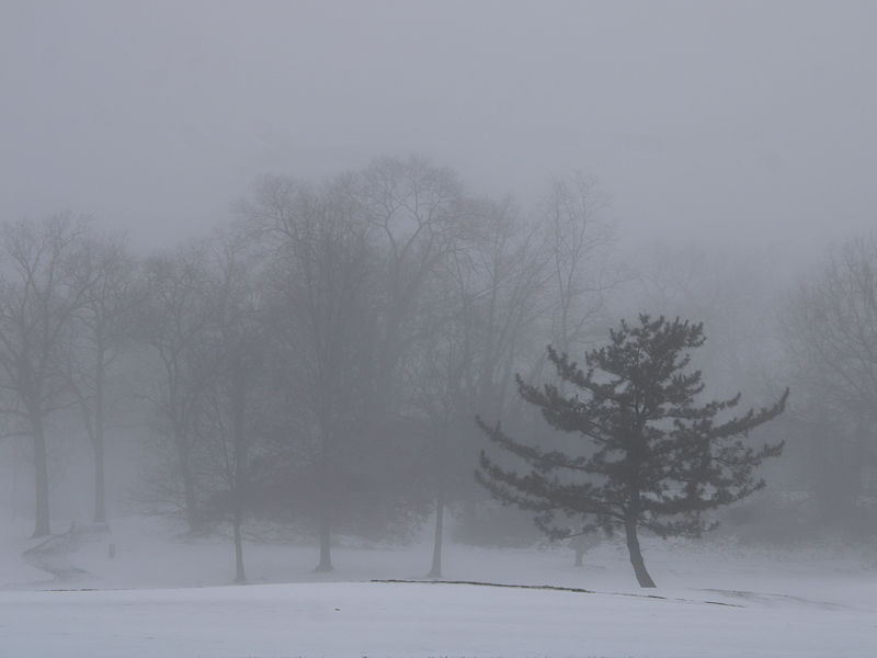
Some morning fog as the warm, moist air as moved over snow-covered landscape.
-
Big dog at 240 on the cmc
-
Ice Ice Baby December 28-29 Storm Discussion
VivaManchVegas replied to Baroclinic Zone's topic in New England
I have been bouncing between 32.5 and 32.9 since i got up 4 hours ago.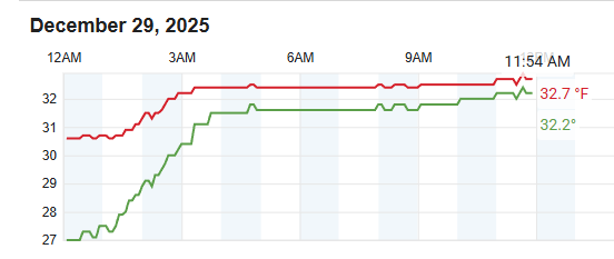
-

January 2026 regional war/obs/disco thread
Typhoon Tip replied to Baroclinic Zone's topic in New England
You get the impression the GFS' recent topography is trying to get organized around the 6-7-8 dates but its not focusing. It's a bit early yet, yup. For now, buck shot with S/Ws through the medium and time span. There's some S/W spacing at 500 mb that looks innocuous and weak 5-6, followed by a more potent amplification nearing the 7-8 period, but the stuff in the 5-6 is just enough to interfere and limit what the 7-8 can do. So you end up with a whole lot of nothing. But that's just the operational GFS Meanwhile, in honestly the ensemble spatial synoptic cinemas looked like shit to me from overnight. I was hoping for more from those. Based on what could have been, when observing the erstwhile trends, no. They instead come up with this half commitment between a new -EPO, and a stressed low amplitude +PNA... in other words, garbage pattern. It's garbage because [ no one will read it anyway ] ... The collapse of the eastern hybrid -WPO is still high confidence spanning the first week. The models are having difficulty coming in with a coherent new paradigm after the fact. May need more time. If it ends up in some distorted piece of shit between two modes it's unclear a best what the f that will mean. Could be anything, but probably not winter storms because that means nothing is actually happening. If it ends up more committed to a +PNA then we'll emerge a system E. I said back in early Sept: early blocking and winter pattern followed by sputtering mid season, and then early spring. So far, nailed the first 1/3. We'll see where this goes. -
Gonna be some gnashing of teeth the next week or so I’m afraid. It’s going to be interesting to see this block develop but as the pacific gets squared away, I think we’re going to be working through some table setters. I’m bullish on our odds once we get the PNA to pop though.


