All Activity
- Past hour
-

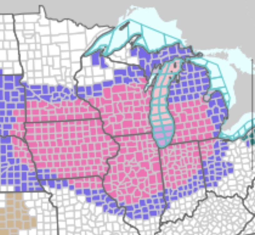
Nov 28-30th Post Turkey Day Winter Storm
CheeselandSkies replied to Chicago Storm's topic in Lakes/Ohio Valley
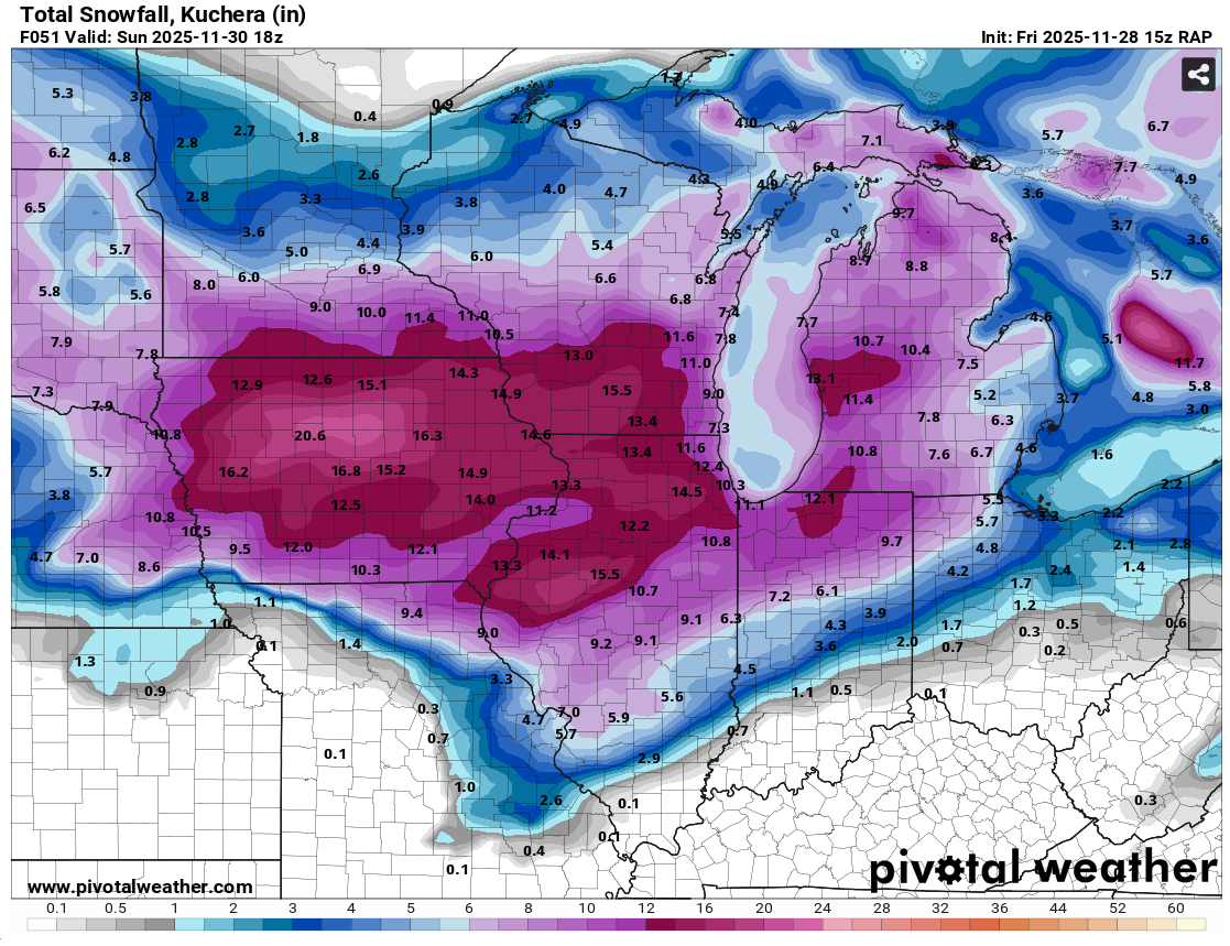
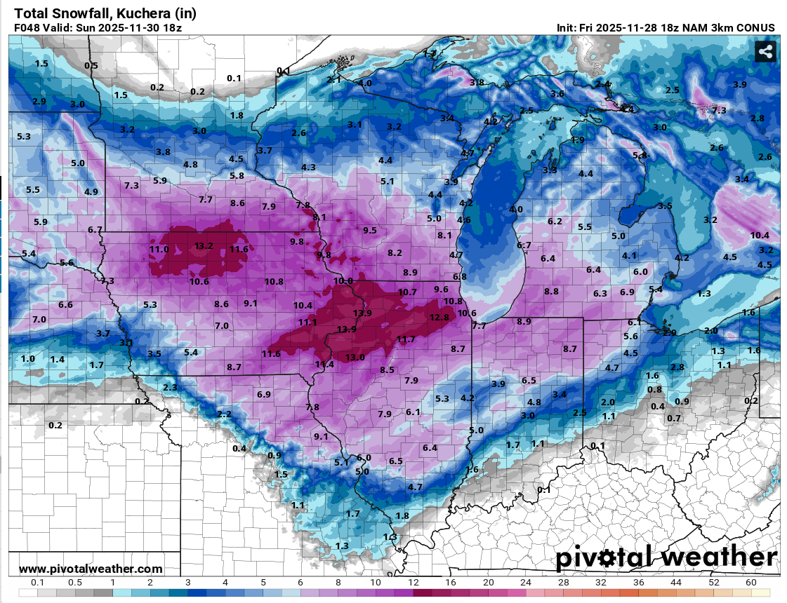
18Z 3K NAM backed off a bit from its prior few runs, down to a "mere" 8.2" for Madison by 18Z (noon CST) Sunday. Even that would be exceptional for before December 1st. However the 15Z RAP was all in on a top-end big dog with 15.5" at the same forecast hour.

-

Nov 28-30th Post Turkey Day Winter Storm
sbnwx85 replied to Chicago Storm's topic in Lakes/Ohio Valley
Potential for two top 10 November snowfalls in the same year in South Bend. Maximum 2-Day Total Snowfall for SOUTH BEND AP, IN Click column heading to sort ascending, click again to sort descending. Period of record: 1893-12-01 to 2025-11-26 1 20.5 1977-11-26 0 2 18.0 1911-11-03 1 - 18.0 1911-11-02 1 4 14.6 1977-11-25 0 5 14.3 2025-11-10 0 6 13.6 1951-11-07 0 7 13.5 1930-11-27 0 8 13.4 2014-11-14 0 9 13.0 1930-11-26 0 10 12.3 2014-11-13 0 -

December 2025 regional war/obs/disco thread
Damage In Tolland replied to Torch Tiger's topic in New England
BOX keeps insisting elevation event . Do not agree totally on that . Especially North of 90 An interior/higher-elevation mainly snow with lower-elevation/coastal plain wet, gloppy snow-to-rain scenario remains a best guess as to precipitation types; -

First Winter Storm to kickoff 2025-26 Winter season
ORH_wxman replied to Baroclinic Zone's topic in New England
Looks like it's hung up in CNE at 72h....18z Mon....we really want that further south for maintaining snow down to BOS to MMK line unless the mechanics of this change a bit. One of the things that happens if you drive the height field lower over us prior to that approaching shortwave, is that it creates more confluence when that shortwave approaches. We saw a bit of this on some prior runs a few days ago when that high was kind of sticking near CAR longer before finally retreating....I made the comment that some areas could get a good front-ender even if it flipped. The trend has been away from that for several cycles now, but if it trended even a little back toward that, it would make a huge difference....particularly for people closer to the coast and further south. I don't think it's a big deal over the deeper interior. -
Weeklies
-
 Enjoy that--i only saw them once. Great show. I think it was Paul O'Neil's last tour before he died.
 -

Mid to long range discussion- 2025
WinstonSalemArlington replied to wncsnow's topic in Southeastern States
-
It was more like 2.5-3 overnight here…stopped at some point then started back up around 730am. 5” measured since 930 when it was shoveled. It is really good out there. Last year thanksgiving weekend was best in years, but this is better… .
-
Cold is coming

-

-
As I’m sitting here watching college football listening to my father-in-law repeat whatever the commenters say I’m reminded of last year when he was here around Christmas…and used my snow board as a serving tray for the wildlife place to dump leftover food on…yeah, the wife had to talk to him about that.
-

December 2025 regional war/obs/disco thread
HoarfrostHubb replied to Torch Tiger's topic in New England
Hold your loved ones safe -

November 2025 general discussions and probable topic derailings ...
ineedsnow replied to Typhoon Tip's topic in New England
Ya we got free tickets so something different to do -
Moderate to occasionally heavy upslope here for the past few hours. I think we've gotten 2" or so but it's hard to tell because the wind is so strong it just blows it around. 19F right now.
-
Nice little squall in Brookline where I am.
-
Nah he knows when I get excited it’s go time. But he gives me shit sometimes when I’m down on an event. At least he remembers blizz 22 well. I said it took me over 16 1/2 years to see anything like that and that was way more ferocious.
-

Nov 28-30th Post Turkey Day Winter Storm
Radtechwxman replied to Chicago Storm's topic in Lakes/Ohio Valley
18z wasn't as nice on nam's as it was on 12z for here. Im so close to being in that jackpot zone. Still will be a solid storm and will beat anything I got last year by a long shot. But man a slight shift south would be nice. Ha -

Nov 28-30th Post Turkey Day Winter Storm
Harry Perry replied to Chicago Storm's topic in Lakes/Ohio Valley
-
Squally...
-
 Went one year, they put on a pretty good show.
 -

Nov 28-30th Post Turkey Day Winter Storm
migratingwx replied to Chicago Storm's topic in Lakes/Ohio Valley
18z 3k NAM came in nice and healthy.


-

Nov 28-30th Post Turkey Day Winter Storm
ILSNOW replied to Chicago Storm's topic in Lakes/Ohio Valley
November and during the day!!!! -
Just checked radar and wow! Is anything even close to reaching the surface?
-

Nov 28-30th Post Turkey Day Winter Storm
tuanis replied to Chicago Storm's topic in Lakes/Ohio Valley
In November, no less. Hoping for 8” here, anything more is bonus snow. -
First Winter Storm to kickoff 2025-26 Winter season
moneypitmike replied to Baroclinic Zone's topic in New England
That would work. We should be close to that rogue EC run that looks to end the world and then "returns to the regular program, already in progress."