All Activity
- Past hour
-

Central PA Summer 2026 Discussion/Obs Thread
Itstrainingtime replied to Voyager's topic in Upstate New York/Pennsylvania
I will add that even though he expects absolutely zero severe weather, he is anticipating a very windy Thursday PM with gusts to 40mph without storms. -

2026 Spring/Summer Mountain Thread
Maggie Valley Steve replied to Buckethead's topic in Southeastern States
I just had a brief shower that was not expected today. The NHC will begin issuing Advisories for Potential Tropical Cyclone 1 at 11:00 AM Eastern time along the Texas/Louisiana Coast. Current track guidance keep the center passing to our S later this week. I've noticed that rain amounts has been increasing the last 24 hours for our SW Mountains into Haywood County. -
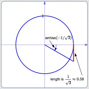
That's what really popped out of the data for me was the shear... About as high as it can be - Anytime I have a chance to lose my audience in here, I take it! so here we go: whenever you see high arctan angles ... ex, .... resulting from curvature of the pressure field ( the circle), and you are in the SE quadrant of a total cyclonic envelope like below, you have large +helicity where ... ...is located. Throw the fact that there's prooobably a warm boundary subtended/cutting straight across the tendency to turn, with it's excessively focused frontal induced curvature sending local tendencies into insane SRH... that becomes a total constructive feedback that sends roof tops on a magic carpet ride. Now... consider the 570+ thickness advection clear to Brian's latitude, with 576 testy hairs tickling the pike... with QPF smeared around the illustrations? That means you have very low LCL's to draw any rotating columns down into the boundary layer. ...as though that's even needed on the former constraints. my god I mean ... may as well just put a tornado warning for everywhere now and call it a day
-
yeah happy to up here in the non-tornadic wind and flood zone
-
Severe is one thing as it is, but I'm actually scared of flooding because the Saturday night or whatever storms that rolled through had my exhaust entirely submerged overnight, like the tips were at least two inches underwater as were the bottoms of my doors. Fortunately I still drive the tornado intercept shit box worth roughly the gas in its tank but my understanding is an outbreak miss south might mean more qpf up here, which may not work out great. Like half of my complex's parking lots were underwater because the storm drains were backing up. I saw the hydrological outlook or whatever and it was not too encouraging
-
(002).thumb.png.6e3d9d46bca5fe41aab7a74871dd8af8.png)
Central PA Summer 2026 Discussion/Obs Thread
ChescoWx replied to Voyager's topic in Upstate New York/Pennsylvania
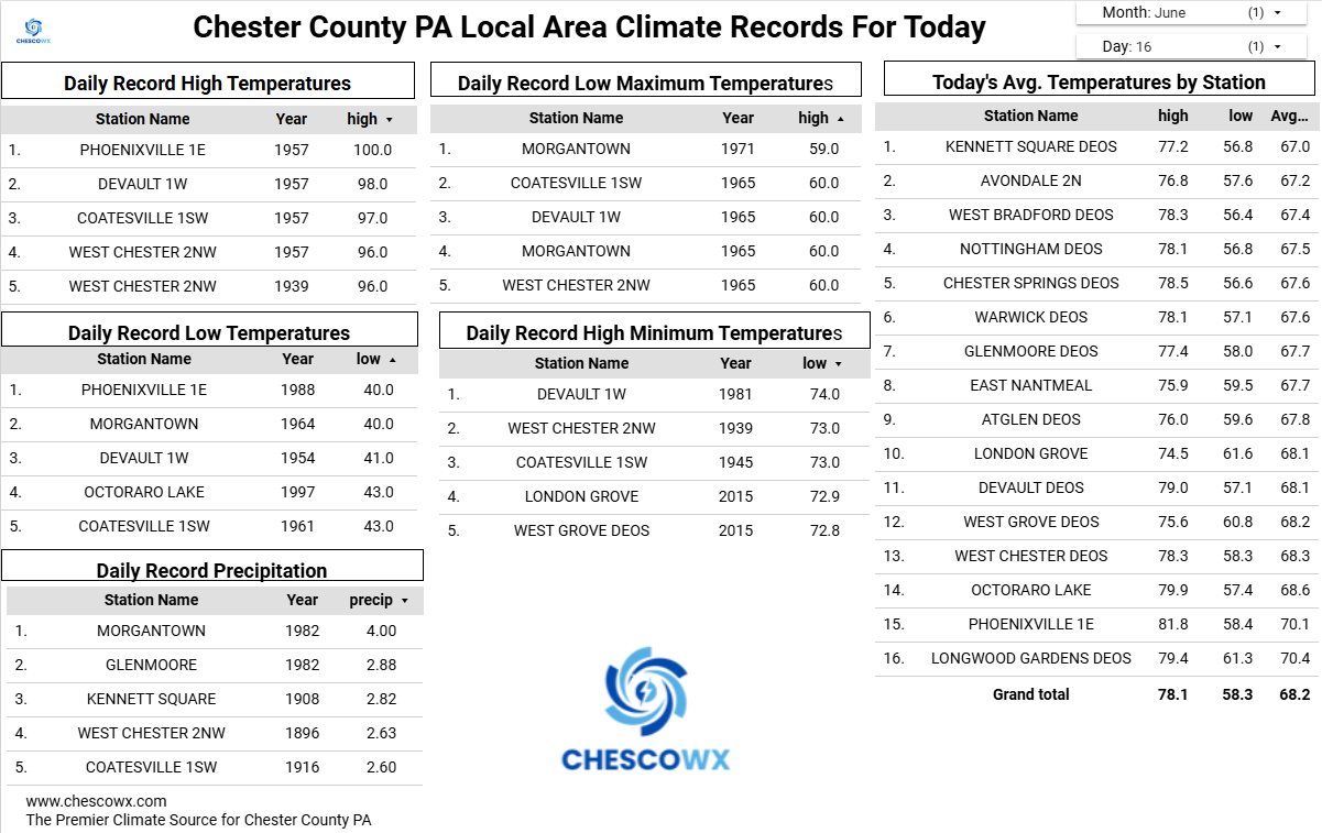
Plenty of chilly lows in the 40's across Chesco valley locales this AM. The lowest I could find was the 45.8 low at our typical chilly spot up in Warwick Twp. Another near perfect day on tap today with highs from the mid 70's along the ridges to the upper 70's in the valleys. We warm up with shower chances both Wednesday night and Thursday with highs well into the 80's. We turn cooler again for the weekend with highs remaining in the 70's in the higher spots with lots of sunshine.
-
E PA/NJ/DE Summer 2026 Obs/Discussion
ChescoWx replied to PhiEaglesfan712's topic in Philadelphia Region
Plenty of chilly lows in the 40's across Chesco valley locales this AM. The lowest I could find was the 45.8 low at our typical chilly spot up in Warwick Twp. Another near perfect day on tap today with highs from the mid 70's along the ridges to the upper 70's in the valleys. We warm up with shower chances both Wednesday night and Thursday with highs well into the 80's. We turn cooler again for the weekend with highs remaining in the 70's in the higher spots with lots of sunshine.
-
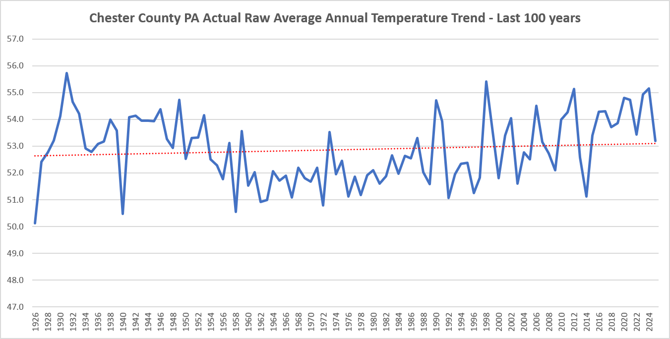
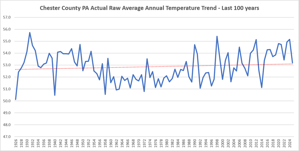
Sure after chilling adjustments made to the past for 90 consecutive years across Chester County......below is the realistic and actual temperature graph covering the last 100 years....no climate crisis here without those consistent post hoc alterations to the actual real data! Still trying to get as warm as the old days back in the 1930's and 1940's!
-
FWIW, MRGL added on 1300z OTLK from SPC for just east of i95 corridor and the Delmarva for tonight... 0/5/5 .Delmarva/coastal Mid-Atlantic... Some strong/locally severe thunderstorms could occur tonight as convection develop near/north of a near-coastal/offshore surface low and northward-advancing warm front. Storms will tend to be elevated inland, but modest buoyancy and strong unidirectional shear through the cloud-bearing layer could yield some hail and/or gusty winds.
-

Central PA Summer 2026 Discussion/Obs Thread
mahantango#1 replied to Voyager's topic in Upstate New York/Pennsylvania
Would love to see a feisty thunderstorm here with rainfall of an inch. It's getting dry here. -
LOT’s AFD goes crazy Wednesday: An unusually powerful shortwave trough is progged to race east-southeastward into the upper Midwest and western Great Lakes Wednesday into Wednesday evening. Model guidance is in good agreement on the synoptic scale with 500 mb heights progged to be 3-4 standard deviations below normal for mid June. At the sfc, an associated low pressure that could threat all- time monthly record for June is expected to develop across Wisconsin and eventually move into lower Michigan. Unsurprisingly, the kinematic fields with such an anomalously strong system are also nearing the upper echelons of what we see this time of year in the Midwest. All of this to say that synoptically, the ingredients are coming together for a potentially dangerous outbreak of severe thunderstorms and potentially long-tracked, intense tornadoes. On the mesoscale, there are naturally greater uncertainties regarding precisely where (and to a lesser extent, if) the overlap of exceptionally strong deep and low level shear and moderately strong instability will take place. SPC`s latest SWODY2 highlights areas south of I-80 in our CWA with a rare day 2 moderate risk (level 4 of 5) for Wednesday. The potential ceiling for bad this severe weather event could get is quite high, but it is also important to note there are obviously still failure modes that could materialize on the mesoscale and prevent the reasonable worst case scenario from unfolding. The general expectation as it looks now is that a strong low level jet (increasing to 60kt+ at 850 mb by 12z Wed) will result in very strong low level theta-e advection and eventually the development of strong to severe thunderstorms late tonight. Initially development is expected over eastern IA, but as the low level jet translates eastward into IL, it should support this convection developing/moving into northern IL near/after sunrise Wednesday morning. While this convection will be elevated, strong effective shear and a reservoir of 1000-2000 J/kg of MUCAPE should allow for elevated supercells. The greatest severe risk Wednesday morning looks to be over our western and eventually southern CWA. In addition to the threat large hail, strong shearing instability near a sharpening frontal inversion would point to at least some threat for the development of gravity wave associated convection. Should this occur, a damaging wind threat could also develop, despite little or no sfc based instability. In fact, there could even be pockets of locally significant severe wind gusts (>75 mph) near or just west/south of our CWA Wednesday morning. This convection will probably evolve into an MCS as it tracks east across northern IL and into northwest Indiana Wednesday morning. The morning convection will likely augment the warm frontal position and at least initially slow the northward progression of the composite warm front/outflow boundary, delaying destabilization north into our CWA. This seems to be the most obvious potential failure mode: morning convection retarding the northward surge of the warm front and subsequently the stronger instability, keeping the extreme wind shear profiles and strong synoptic forcing somewhat divorced from the more favorable instability. While that is one potential obvious failure mode, at this point, it seems unlikely to fully succeed in completely disrupting the otherwise exceptionally favorable synoptic set-up from resulting in a high end severe threat. Though the precise location of the most likely area(s) to see a high end event, could change some on the mesoscale as the event nears. The reason that this morning convection is unlikely to completely stunt the northward surging warm front is the extremely strong mass response expected as a result of the near record deep low pressure system. With a far less intense low last Thursday, an impressively large footprint of a cold pool left behind from an MCS that lingered well into the afternoon was able to be completely overcome in just a matter of a couple of hours late in the day. Something similar seems plausible again tomorrow afternoon where a dissipating outflow boundary from early convection could separate an extremely volatile air mass from a still sufficiently unstable air mass north of the boundary could support severe thunderstorms with damaging winds and isolated tornadoes. There is variance in guidance with just how far north the effective boundary will get, but somewhere generally in the vicinity of I-80 is where a majority of the models show it reaching its peak latitude in our CWA. To the south of this boundary, the environment looks similar to what`s often seen in the cool season major tornado outbreak in the southeastern United States. Forecast hodographs are literally off the chart, with 0-1 environmental SRH >500 m^2/s^2. This sort of extreme low level shear, coupled with low LCLs and resultant strong 0-3km CAPE, fast storm motion, and favorable downstream environment is the classic type of set-up long tracked strong- violent tornadoes. It`s important stress that while the synoptic set-up is classic for a tornado outbreak, we are dealing with convection that often alters the mesoscale environment in ways that cannot be anticipated 12-24+ hours in advance. As noted above, there are certainly scenarios where an alteration of the mesoscale environment could dramatically reduce or shift the area of the greatest tornado risk. For this reason, it is important to monitor later forecasts closely. Finally, in addition to the supercell tornado threat, a fast moving line of severe thunderstorms/possible derecho may also accompany the front producing widespread, potentially significant, wind damage as well as line embedded tornadoes, some possibly strong. Not to be overlooked, precipitable water values are progged to get to near or just above 2", meaning that convection will likely be extremely efficient rain producers. The stronger convection could easily produce 2"+ of rain in just an hour or so. Given the antecedent very moist ground and generally above average streamflow, there is a threat of flash flooding Wednesday. The greatest threat may be with the first round of convection, since it will likely be a bit slower moving and offer a better chance of some training cells than the second round. When the area most at risk can be better refined, we will need a flood watch for portions of the area for Wednesday as well.
-
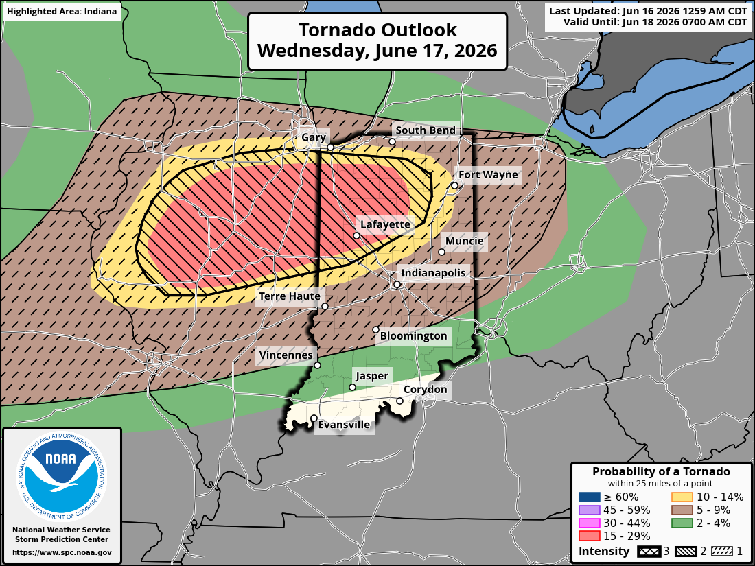
Tomorrow’s tornado probs… for posterity sake. 5% hatched imby, but 15% double hatched is just 30 minutes south.

-

Chester County PA - Analytical Battle of Actual vs. Altered Climate Data
rygar replied to ChescoWx's topic in Climate Change
I asked AI for a realistic and true temperature graph for Chester County PA, covering the last 100 years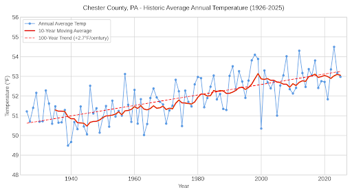
-
I wish Thursday trends north but that’s “pie in the sky”
-
An appetizer, if you will.
-
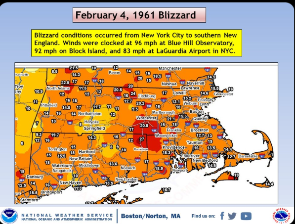
With how measurements are done now, these totals would likely be 1.5x what was reported here: Tblizz would be reporting a 30 burger with that storm track
-
Central PA Summer 2026 Discussion/Obs Thread
Itstrainingtime replied to Voyager's topic in Upstate New York/Pennsylvania
MU gettin' feisty... MU Weather Center The SPC has placed us under a "slight risk" for #severewx on Thurs, but I strongly disagree. The setup is basically a "rinse and repeat" of last Friday. Strong, WSW flow will cause a "downsloping" effect off the Apps, & leftover convection moves through during the morning hours. -
If NJ was getting soaked on models, I feel like the fear would be it stays south and Stein has a grip, ha. There’s no spot on a map for moisture that would illicit a “this looks good right now” .
-

Central PA Summer 2026 Discussion/Obs Thread
NepaJames8602 replied to Voyager's topic in Upstate New York/Pennsylvania
A delightful 43 here this am. -
All true, and the newsies seem always focused on the worst-case scenarios. ("If it bleeds, it leads.")
-
Wait for it - "it always trends north"
- Today
-
Central PA Summer 2026 Discussion/Obs Thread
Itstrainingtime replied to Voyager's topic in Upstate New York/Pennsylvania
That's a superb basketball hoop you have there! -

Invest 90L--60% Two Day, 60% 7 Day Development Odds
WxWatcher007 replied to WxWatcher007's topic in Tropical Headquarters
-
Possible, could also go so far under you it stays dry too. But I get it, you’ll never even give it a chance of happening for the next 5 months regardless of model data.
-
Though it's now #3, that 1947 storm might've been Central Park's biggest, exceeded due to measurement changes. My opinion is based on snow depth. The 12/47 event pushed the pack from 2" to 26" (NYC's tallest on record), while #2 - Feb 2006 - only reached 17" and #1 - Jan 2016 - brought the depth from zero to 22". I think that Central Park records depth at noon, or why the 26th only reported 4" despite nearly all the snow fell before midnight, and that 26" pack was measured about 10 hours after accumulation had stopped. The numbers: 12/25 33 19 0 0 2" 12/26 31 25 2.36" 26.1" 4" 12/27 35 29 0.04" 0.3" 26" We'll never know for sure.