All Activity
- Past hour
-

The “I bring the mojo” Jan 30-Feb 1 potential winter storm
buckeyefan1 replied to lilj4425's topic in Southeastern States
Ya'll, he is talking about this specific model run directly over his backyard just like the rest of us would. You've all seen his maps. That is not what he thinks. Jeez. Just because there is a red/orange tag under someone doesn't mean that they can't get disgruntled and jump off the cliff. Not saying it should be here in this thread either Just saying he's human like the rest of us -
Same for the ticks! Last winter was cold and less snowy and the ticks were brutal!
-

The “I bring the mojo” Jan 30-Feb 1 potential winter storm
Silver Meteor replied to lilj4425's topic in Southeastern States
I'd laugh but being in Pitt County (Greenville) that's too close for comfort at this stage of the game. -

Possible coastal storm centered on Feb 1 2026.
WinterWolf replied to Typhoon Tip's topic in New England
Nice! It’s gonna be awesome. Got home Saturday night…and it couldn’t be any better. Stellar. You’re gonna have a fabulous trip. Going back up in two weeks…planning to do the Gaspe’. -

February 2026 Medium/ Long Range Discussion: Buckle Up!
Paleocene replied to Weather Will's topic in Mid Atlantic
18z op euro has the wave too, it's weak and disorganized but we get some pow pow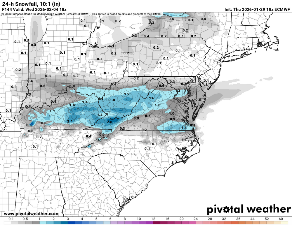
-
I think we all have been watching this rodeo for quite a while and we all know the things that can go right anf wrong and there is just so much you can say.
-

Possible coastal storm centered on Feb 1 2026.
Torch Tiger replied to Typhoon Tip's topic in New England
-

Arctic Hounds Unleashed: Long Duration Late January Cold Snap
Brewbeer replied to WxWatcher007's topic in New England
That already happened, check previous page, the usual suspect -

The “I bring the mojo” Jan 30-Feb 1 potential winter storm
eyewall replied to lilj4425's topic in Southeastern States
not really no. -

Central PA Winter 25/26 Discussion and Obs
canderson replied to MAG5035's topic in Upstate New York/Pennsylvania
@Mount Joy Snowman said it best the other day - the river and shore and indistinguishable. -

Possible coastal storm centered on Feb 1 2026.
ineedsnow replied to Typhoon Tip's topic in New England
ill give it to 0z -
After seeing all those big numbers towards the triad before, if I end up in the bull’s-eye, I’m gonna laugh my ass off.
-
Well… wasn’t expecting this…still going conservative until tomorrow morning i guess .
-

The “I bring the mojo” Jan 30-Feb 1 potential winter storm
PeeDeeWx replied to lilj4425's topic in Southeastern States
Ok. Latching on to a tiny spot. But even at 3, dumpster fire? That’s pretty close to your annual snowfall, no? -

The “I bring the mojo” Jan 30-Feb 1 potential winter storm
Upstate Turfie replied to lilj4425's topic in Southeastern States
How do I hit print? -
Same. NWS Gsp has me at 8, RAH has me at 8, but Brad P has me at 2-5. Im going 3-4 and dont expect more. I think latest Euro had me at 10 too lol
-

Winter 2025-26 Medium/Long Range Discussion
Chicago916 replied to michsnowfreak's topic in Lakes/Ohio Valley
Ironically I was in Whistler the end of December and they actually had snow the week I was there and enough of it with high winds to cause problems. Still better off than having no snow. -

Possible coastal storm centered on Feb 1 2026.
dryslot replied to Typhoon Tip's topic in New England
Heading up to the county next week. -

The “I bring the mojo” Jan 30-Feb 1 potential winter storm
Regan replied to lilj4425's topic in Southeastern States
And you put weight on that tiny bubble? Lol -
Richmond Metro/Hampton Roads Area Discussion
Berlin1926 replied to RIC Airport's topic in Mid Atlantic
Ive seen 18" in ENC and nothing in Raleigh in the past. I pray this isn't the same. -
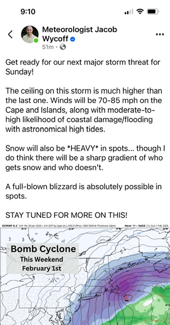
I can’t imagine over a foot of this powder plus those winds coming. Monday night could be some crazy conditions we haven’t seen in a long time. Plus the cold and crazy wind chills.
-

2025-2026 Fall/Winter Mountain Thread
Tyler Penland replied to Buckethead's topic in Southeastern States
So... Saturday and Sunday. Got it. LOL The Warning alone has that criteria in it- 4-7" of snow plus sustained 35, gusts to 60. From the AFD That said, conditions will remain hazardous due to the amount of wind that is being forecast. As the storm deepens along the coast expected winds to increase areawide Saturday night into Sunday with wind gusts ranging from 40 mph in the piedmont to as much as 60 mph across the mountain ridges. This will result in considerable blowing and drifting snow. All of the snow that falls will be falling on a layer of ice (the compacted snow and sleet of the previous storm). Due to the lack of friction, all of the new snow will become available to blow with the wind... which means there will be a lot of drifting and roads being inundated from wind swept snow. -

The “I bring the mojo” Jan 30-Feb 1 potential winter storm
AGardiner87 replied to lilj4425's topic in Southeastern States
Upstate special! -

Possible coastal storm centered on Feb 1 2026.
Ginx snewx replied to Typhoon Tip's topic in New England
I have liked that one for a while. Tips NJ subsume potential -
The “I bring the mojo” Jan 30-Feb 1 potential winter storm
Regan replied to lilj4425's topic in Southeastern States
Taking that 3in spot literally is like deciding where the tiger’s stripes will be before it’s even conceived. That spot likely won’t exist come time.