All Activity
- Past hour
-
Looks like Euro and GFS give everyone a 2"-4" event with localized 5" spots.
-
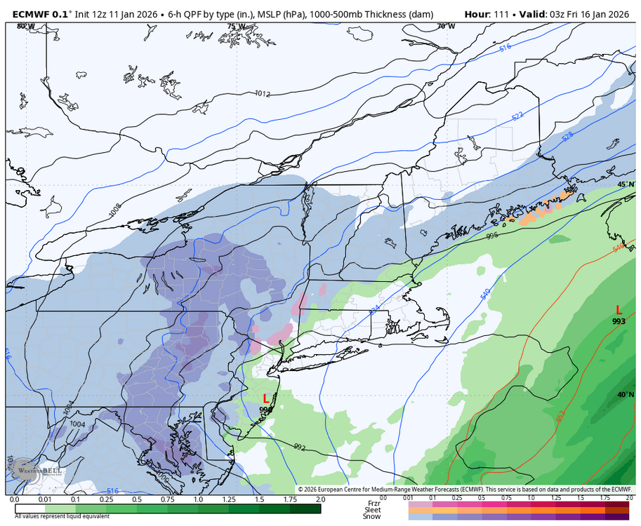
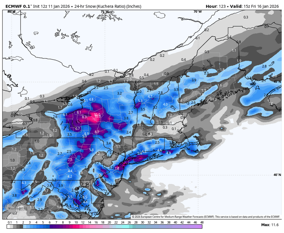
Barring some big changes in the guidance, it continues to appear that the Thursday-Friday period will see some precipitation, but probably < 0.50". A series of waves should move along a slow-moving front, but the consolidated low will likely develop too far offshore for a more significant impact. Larger impacts remain more likely across southeastern and eastern New England. Currently, fewer than 20% of EPS ensemble members show 0.50" or more QPF for the New York City area. The 1/11 0z EPS ensemble mean QPF was pretty close to the 16z NBM output. Overall, there remains little evidence that a pattern conducive to large snowstorms coupled with the ingredients necessary will be in place by the January 15-16 timeframe. Nevertheless, rain showers could transition to snow showers or even some periods snow around the New York City area and its immediate suburbs. A light accumulation of snow is plausible. More immediately, a line of rain and/or snow showers accompanying a frontal passage appears likely to cross the region late this afternoon or early this evening coupled with gusty winds. No accumulation is likely in and around NYC, but temperatures should fall from the middle 40s into the upper 30s or lower 40s during the frontal passage.
-
Shure looks like it should be with that look. Question is, does something cave here for better.. or worse
-
Huge huge improvement on the Euro hopefully that 5H trend holds. Very snowy 12 Z Run
-
4" here so far and the radar keeps filling in over the lake, nice surprise. I think the RGEM was the only model to show anything more than a few inches.
-
It is in fantasy land, but the end of that 12z Euro run is gonna get a lot of press if it can reproduce that tonight. The 12z GEM was flirting with it. With it being January, an EPO ridge in place, and blocking over the top....there is definitely a risk of very cold air getting trapped under that block and sent south. I don't see a clear signal yet, but deterministic runs are flirting with it. Not sure I want any part of that.
-
That actually makes me feel better, now maybe I should pay attention
-
They still need quite a bit to get to 24
-
Ahhh winter is back.
-

Central PA Winter 25/26 Discussion and Obs
Blizzard of 93 replied to MAG5035's topic in Upstate New York/Pennsylvania
-
Strongly agree. The model has been a consistent outlier with its fantasy snowstorms and blizzards. What’s worse is that people are misappropriating it to social media to drum up hits on their pages and sites.
-
We’re on life support for system 1 imo, east of the mountains. Gotta hope for some better trends for late week the next few days.
-

E PA/NJ/DE Winter 2025-26 Obs/Discussion
penndotguy replied to LVblizzard's topic in Philadelphia Region
41F/Dp28 winds Nw @15 gust 27 1-3,2-4,4-8 etc. I’ll take whatever the pattern gives us, we had pretty Decent December so let’s keep it up in January. Don’t get me wrong a SECS or MECS would be great but something is always better than nothing. -
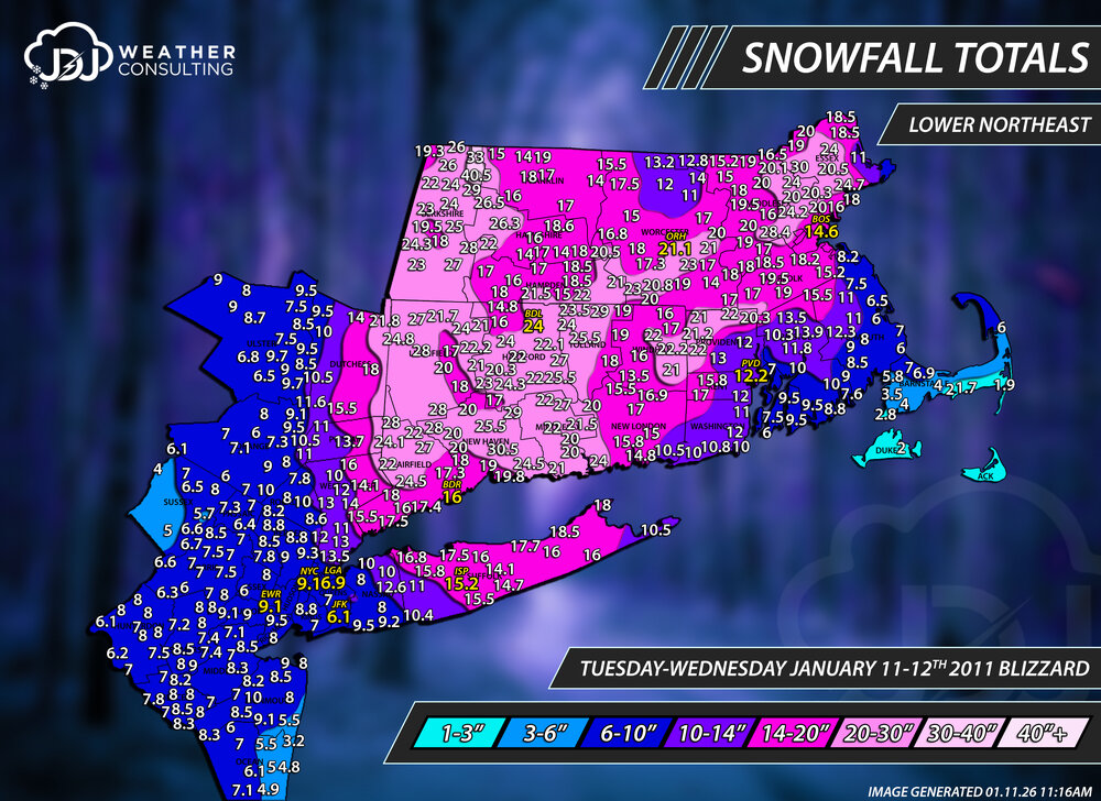
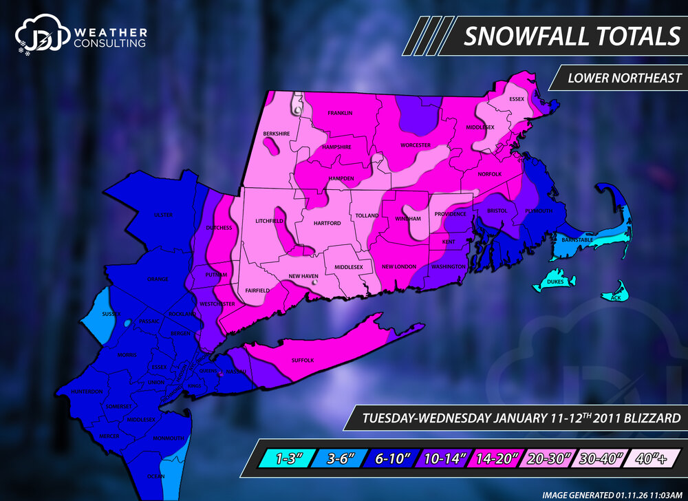
Today is the 15 year anniversary of one of CTs biggest snowstorms on record. BDL #1 all time with 24". And overall probably the 2nd biggest (for CT in general) in the past 30 years. Just finished redoing all these maps for accuracy and to include Lower Northeast view with climo sites. One of the most perfect radar evolutions for SNE and especially CT. This storm is actually the only storm i've done that has a 40"+ contour other than 1888. Savoy, MA 40.5", Florida 33", North Haven 30.5" https://www.jdjweatherconsulting.com/post/15-years-ago-january-2011-blizzard Contours only
-
The GFS “blizzard” yesterday was a real leg slapper lol Go with the EPS :-)
-
Central PA Winter 25/26 Discussion and Obs
Blizzard of 93 replied to MAG5035's topic in Upstate New York/Pennsylvania
Best Euro run yet for the Thursday chance for the Susquehanna Valley. -
Euro AI is a non event
-
Nice snow hole over Winchester. It has to be correct.
-
Didn't know you went to UVA! What did you study and any tips for myself?
-
Agree. We would be much better off having pass just a touch south of the VA/NC border.
-
Sorry pal. We had a great December. We’ll probably sneak in a nice event late January and then face a more hostile pattern the rest of winter. i think the park ends with around 24” of snow. I don’t see it going much more than that
-
Would we even know where the banding would setup or is it almost fully a nowcast situation and praying it goes over your house?
-
You should know all about that. Also explain the Euro more or less siding with it for the late week storm.
-
12z Euro does a little sumthin’ sumthin’
-
I know that street. Lived in that neighborhood for a semester and walked to class through there.


.thumb.JPG.418e8a9a2902ae687ec35ff4bc0e038e.JPG)


