
dsnowman
-
Posts
74 -
Joined
-
Last visited
About dsnowman

Recent Profile Visitors
1,415 profile views


-
Feb 22nd/23rd "There's no way..." Storm Thread
dsnowman replied to Maestrobjwa's topic in Mid Atlantic
I don’t think there is a middle ground here with temps. We either get the earlier phasing / coastal development where rates overcome temps (GFS / NAM) and we get pummeled, or we get a few inches of wet snow (EURO, UKMET). Where have I seen this movie before. . -
Feb 22nd/23rd "There's no way..." Storm Thread
dsnowman replied to Maestrobjwa's topic in Mid Atlantic
The last panel of the NAM has it turning back west (994 to 990), what’s that about? . -
Mother Nature has been throwing us a bunch of sliders down and away. And so we’ve been getting a little anxious, crowding the zone, and so she throws us a few cutters (6z GEFS). Surprised to see that. Hopefully 12z gives us some meat right in our zone.
-
FWIW, 6z ICON is a bump north from 0z with snow into the MA.
-
Forecast high for western Fairfax County today = 30. Actual high temperature = 26. A great battle between the surface and atmosphere is about to ensue.
-
Though not the big snowstorm we all wanted, it’s still possibly a HIGH impact event. It looks like we are in for the snow to ice solution noted yesterday for those of us west of I-95. Though there is raging warm air aloft, the CAD signal is very strong. So not the wash out many have feared. Not surprisingly, the NWS has updated the forecast this morning (I’m western Fairfax County) calling for up to .30 of ice on top of several inches of snow. It’s gonna be a great battle between the surface and upper levels!
-
The globals have locked into the evolution and path of the storm, now it’s time for the meso’s and the finer details. The 6z NAM in particular, but also the ICON and GFS, are recognizing that the cold air isn’t going to be scoured out very fast particularly in the western burbs, so it looks like we may be dealing with more of a snow to ice regime than snow to rain. Could make this storm impact worse than last Mon.
-
Coastal hugger. Much better than 12z!
-
Feb Long Range Discussion (Day 3 and beyond) - MERGED
dsnowman replied to WinterWxLuvr's topic in Mid Atlantic
The 6z GFS is interesting, there is more dig to the trough which creates more spacing between the Sun and Mon waves and allows the Mon wave to hug the coast a little more as it heads our way. Is this the start of something. EDIT: meant 18z. Port causing slurring of my fingers. -
Feb Long Range Discussion (Day 3 and beyond) - MERGED
dsnowman replied to WinterWxLuvr's topic in Mid Atlantic
6z GFS is getting a little closer for Sunday, it just doesn’t phase in time (Maine). As depicted, it’s a little hard to believe, two pieces of energy running in parallel for hundreds of miles without phasing. -
Jan 31st - 33rd Storm Obs and Disco like it's 1979
dsnowman replied to Bob Chill's topic in Mid Atlantic
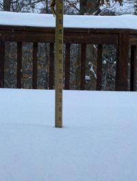
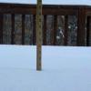
29 and just over an inch in Centreville. Western edge of radar past I-81 looks to be filling in. GFS won the battle of the models from earlier in the week. A EURO suppressed scenario was just plain wrong. That said, 6z GFS has actually brought some of the CCB back towards the DC area. -
I’m with you on that one. A fun story ...it was my 2nd year living in the DC area, and my sister and her friend drove down from CT the day before, as we all planned to drive to Daytona Beach for Spring Break. As the storm approached, we debated on waiting a few days until it passed. But we would have missed part of Spring Break, so late that night we decided to roll. The four of us (my roommate included) piled in my tiny 1985 Nissan Sentra and drove straight through the Superstorm to Daytona Beach. Absolutely crazy. Driving through snow to rain and wind, and arriving to a ruined Spring Break with temps in the 40’s and 50’s most of the week in Daytona Beach. The craziest part was in Georgia where highways were stopped because it was raining so hard, like driving under a continuous waterfall! Never seen anything like it before or since.
