All Activity
- Past hour
-
Thanks!
-
Bitchin Nachos!! Nice write up and map. I toast you a cold frosty Sprite!
-

Possible Record Breaking Cold + Snow Sunday 1/25 - Tuesday 1/27
wthrmn654 replied to TriPol's topic in New York City Metro
I'll ask them and look at they're storm briefing on slack in a mintue. Total QPF for the event should be roughly between 1.0-1.5 inches. Watch mentions a boilerplate 6-12 inches likely with localized accumulations over 12 inches, but the above QPF with higher snow ratios could yield widespread potential accumulations of over a foot -
 I'm not sure why. 10 to 14 inches of snow with a layer of sleet and freezing rain on top of it sticks around a hell of a lot longer than 6 inches of plain snow.
 -

Pittsburgh/Western PA WINTER ‘25/‘26
Mailman replied to Burghblizz's topic in Upstate New York/Pennsylvania
The northward trend has continued to some degree in the latest guidance suite. We still foresee northern Plains and southern Rockies mid-level shortwaves to phase as they cross into the Middle Ohio Valley. As they do so, a surface low develops near the Gulf coast and tracks northeastward. There is still some variance with the track of this low. The northern trend is starting to increase the chance of some mixed precipitation to the southeast of Pittsburgh, and a slight chance of freezing rain has been introduced to the gridded forecast. The chances of this are not high enough to meaningfully change the overall snow totals or the messaging to a significant degree, but it is a trend that we will need to monitor as the event approaches. In any event, support for overall lift remains quite good given a coupled 250mb jet structure, layered frontogenesis, and an inverted surface trough. A moisture surge including precipitable water totals of around 0.7 inch (90th percentile for late January) and a deep, saturated dendritic growth zone will also support significant snowfall totals. -

1/24-1/25 Major Winter Storm - S. IL, IN, MI and OH
WestMichigan replied to A-L-E-K's topic in Lakes/Ohio Valley
As a former Ohioan this is what you hope for and rarely get. Enjoy it! -
 Ha! I'm in Rockaway borough.. I have no idea whether to expect 18 inches or 8. It's facinating.
 -
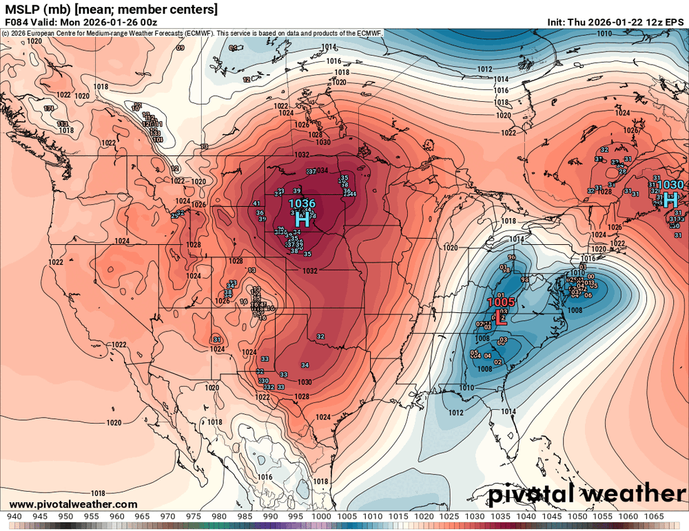
I have no super intelligent commentary to offer on the differences between the EPS and GEFS, but i thought I would make this gif which shows the differences in SLP. Valid Sunday evening/Monday 00z. Easy way to visualize why the GFS 12z was more "friendly" to those of us along/east of 95. We want that low and transfer to the coast to be more south. I assume at this range its probably time to stop looking at ensembles too
-

Possible Record Breaking Cold + Snow Sunday 1/25 - Tuesday 1/27
Wxbear25 replied to TriPol's topic in New York City Metro
The NWS going hog-wild at this point is surprising. Think they get burned going so high, personally, but we’re not THAT far off from a colder, all-snow scenario I suppose -

January 24-26: Miracle or Mirage JV/Banter Thread!
dallen7908 replied to SnowenOutThere's topic in Mid Atlantic
According to AI, table salt is too fine, dissolves too fast, and contains additives that create a sharp, unpleasant flavor. So perhaps they would work better than table salt - but kosher salt recommended. -

Southern MD / Lower Eastern Shore weather discussion
csnavywx replied to PrinceFrederickWx's topic in Mid Atlantic
Fret not. Even if we only get a partial here, the pattern remains very favorable into Feb. Need some true vodka cold to start freezing the Bay up in preparation, if you ask me. -

Pittsburgh/Western PA WINTER ‘25/‘26
TimB replied to Burghblizz's topic in Upstate New York/Pennsylvania
There is an important consideration regarding these totals. With the northward trend in guidance/warm air intrusion, a slight lowering of snow-to-liquid ratio is noted. Ratios may drop to between 10:1 and 15:1 from Pittsburgh on north, and potentially to the 8:1 range or so towards the Mason-Dixon Line. So, a wetter, heavier snow may be possible as compared to previous messaging. These lower ratios may ultimately cut down snow totals as well. We will continue to monitor these trends and adjust accordingly. However, there is fairly high confidence in Winter Storm Warning-level impacts across the forecast area, and an eventual upgrade is nearly certain. It still appears that the heaviest snow should be during the day Sunday, and then tapering off that night. Cold northwesterly flow and the crossing parent upper trough could result in lingering snow into Monday. If they’re putting this in the discussion already, I’m more than a little concerned. -
Thanks! I’m trying over here lol That was a solid map a good representation of what I feel will happen in terms of the ranges and cutoffs. I also don’t think people here are understanding the ratios well start off with around here. Even DC will be like 13-15:1 in the first 3-4 hrs of the storm before things slowly tail off as the warm nose approaches. Further north around the M/D back to WV, 18-20:1 will be common early on and as @WxUSAF mentioned earlier, the localized banding structures will improve ratios locally for times and things can pile up fast. My current thinking for the North and West crew is 12-18” with local to 22” as a max. Subject to change and not my official forecast, but that’s my thought on this. I like your spot and areas west along the M/D a lot. Should be a great storm.
-

1/24-1/25 Major Winter Storm - S. IL, IN, MI and OH
sbnwx85 replied to A-L-E-K's topic in Lakes/Ohio Valley
Some of the icing in the Deep South is going to be devastating. Easily 1" of ice in spots from Texas to Tennessee. -
-

1/24-1/25 Major Winter Storm - S. IL, IN, MI and OH
Jackstraw replied to A-L-E-K's topic in Lakes/Ohio Valley
The pretty high SLR's are gonna play big on totals obviously. Averaging .6 QPF across all the models here which would normally be in the 6in range (yes I know y'all can do math). The farther N the drier but the higher the SLR and possibly a brutal cutoff. Kuchera ratio's 20-1 all the way up into MI on all the models. Its definitely gonna take a little more time to juice up the DGZ (outside of leeside lake enhanced) up here with the growth zone pretty dry to start. Thats killed us in this area a few times this winter and is usually an issue trying to overcome a dry NE flow. To me, thats the biggest wrench that could happen here. It's too bad that as of now there's not much wind on the back end although it doesn't take much out where I live to get good drifting going. If we could get just 20 to 30 with higher gusts it would be bangers. Hate to waste Driftomatic powder. Hoping this thing does a last minute MJ side step fade NW. Make a lot of people more comfy and happy around here -
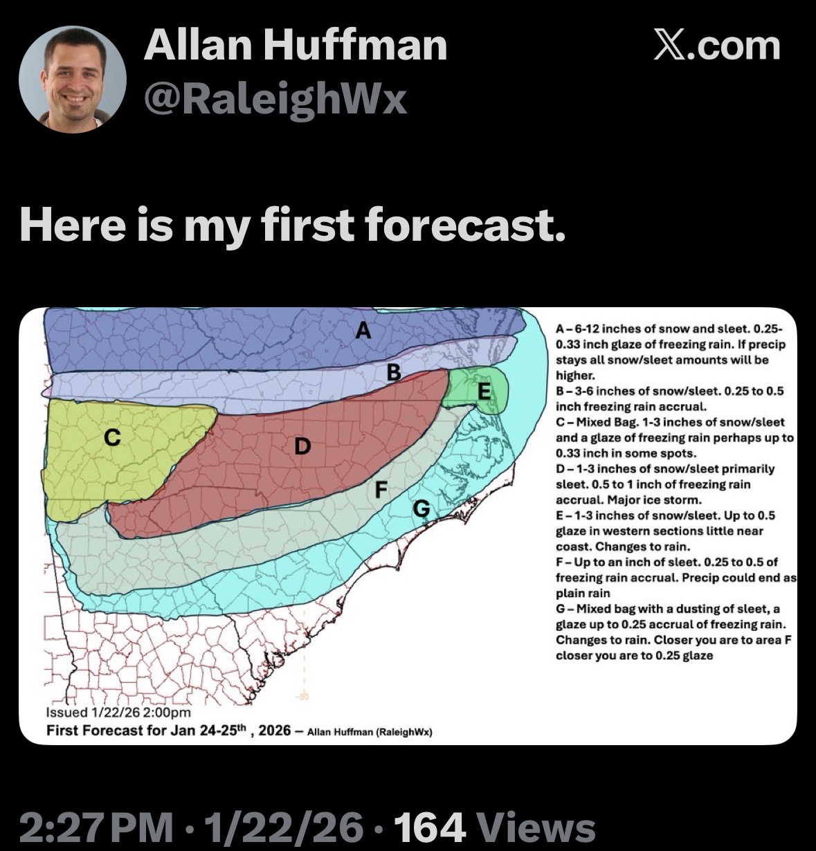
GSP just posted their first call map on social media.
-
Possible Record Breaking Cold + Snow Sunday 1/25 - Tuesday 1/27
Wxbear25 replied to TriPol's topic in New York City Metro
Right, I was originally responding to someone but I did it on Tapatalk instead of the browser by mistake so my response blew up, so I edited it down and cut out some stuff by mistake -

January 24-26: Miracle or Mirage JV/Banter Thread!
H2O replied to SnowenOutThere's topic in Mid Atlantic
None of those salts can be used for margs, can they? Asking for a friend -
Man oh man the cold just keeps unloading out of Canada over the next 10 days or so and MAYBE into early February. The actual temperatures and departure from normal maps are pretty astounding honestly.
-

Possible Record Breaking Cold + Snow Sunday 1/25 - Tuesday 1/27
Metasequoia replied to TriPol's topic in New York City Metro
If this storm underperforms regarding snow, I feel like the March 11ish 2017 storm ( Miller B also ) might be a decent analog. 12 to 20 inches of snow was initially forecasted for NYC, but the City received about a half foot of sleet because the upper low tucked in just east of the Jersey Shore and south of Long Island. Obviously this weekend's storm impacts a much larger portion of the US... -
Seven inches would be Baltimore and north's best storm since 2016. Easily. We are in an epic big snow drought up here.
-
 I definitely would prefer all snow, or just all rain, than sleet, or even worse, freezing rain. Give me 6" of all snow instead of 10"-14" of snow, then sleet or freezing rain on top of it.
 -
1/25-26 First Call Snowfall Forecast From the JV Team Hopefully the map is pretty self-explanatory. That thick blue line is the dividing line between all snow and mixing. Tonight this forecast will be refined. This will likely be the most impactful winter storm in the DMV region since 2016, even though mixing with sleet and freezing rain will occur. Temperatures will be cold throughout the storm and will struggle to reach 25. Snowfall ratios at the beginning of the storm will likely be around 16:1 and will slowly decrease to around 9:1, before mixing, where freezing rain and sleet will make conditions all the more dangerous. Snowfall rates during the heaviest returns will be upwards of 1-2" per hour, occasionally reaching 3" in isolated areas (which are currently unknown as we are too far out for CAMs to realistically hone in on those areas) where h7 FGEN goes crazy (credit to @MillvilleWx). After the storm, temperatures will remain frigid, and it's unlikely that high temperatures reach above freezing until February. Your snow/sleet/ice will turn into glacier. Prepare now. Make sure to get all your essential needs, like food, water, and a source of heat if your power goes out due to the ice.
-

1/23/26-1/25/26 Winter Storm Thread
Holston_River_Rambler replied to AMZ8990's topic in Tennessee Valley
Yeah I was just at the Home Depot and they had a bunch of cheapo plastic shovels marked up to around $30.00