All Activity
- Past hour
-

Junorch obs and discussion 2026
Damage In Tolland replied to Damage In Tolland's topic in New England
Steined is the way of the walk . -
dry and semi warm this summer?
-
I’m feeling outshined
-

2026-2027 Super El Nino
roardog replied to Stormchaserchuck1's topic in Weather Forecasting and Discussion
Now that we’re heading through June we can see the big divergence with 1997 is going to be Nino 4. This shouldn’t really be a surprise to anyone but it’s still a big deal IMO. -

2026-2027 Super El Nino
bluewave replied to Stormchaserchuck1's topic in Weather Forecasting and Discussion
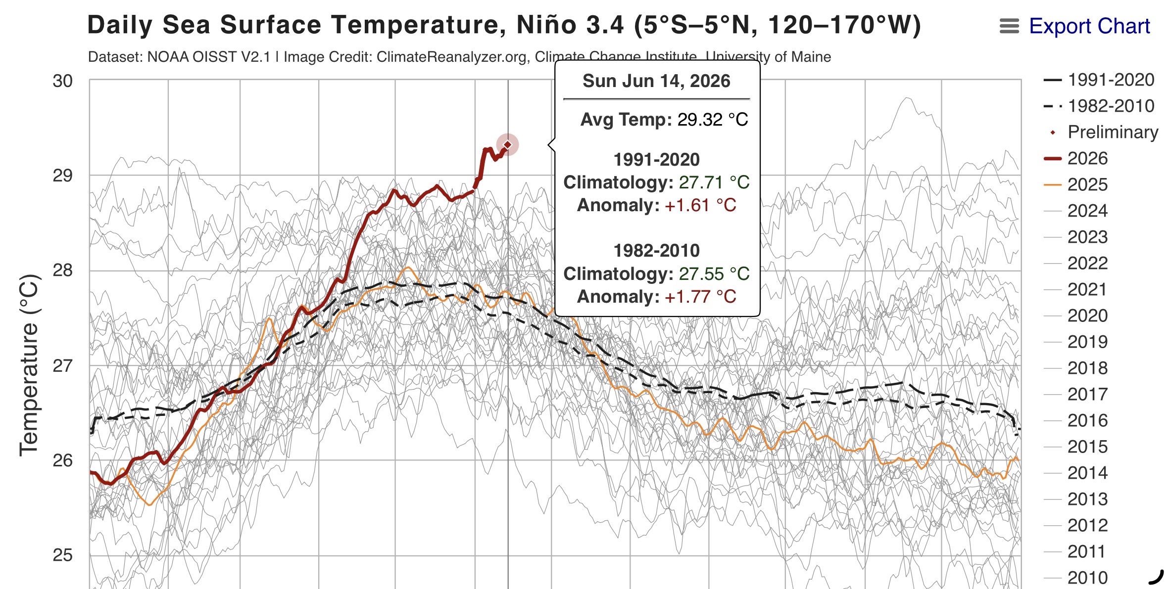
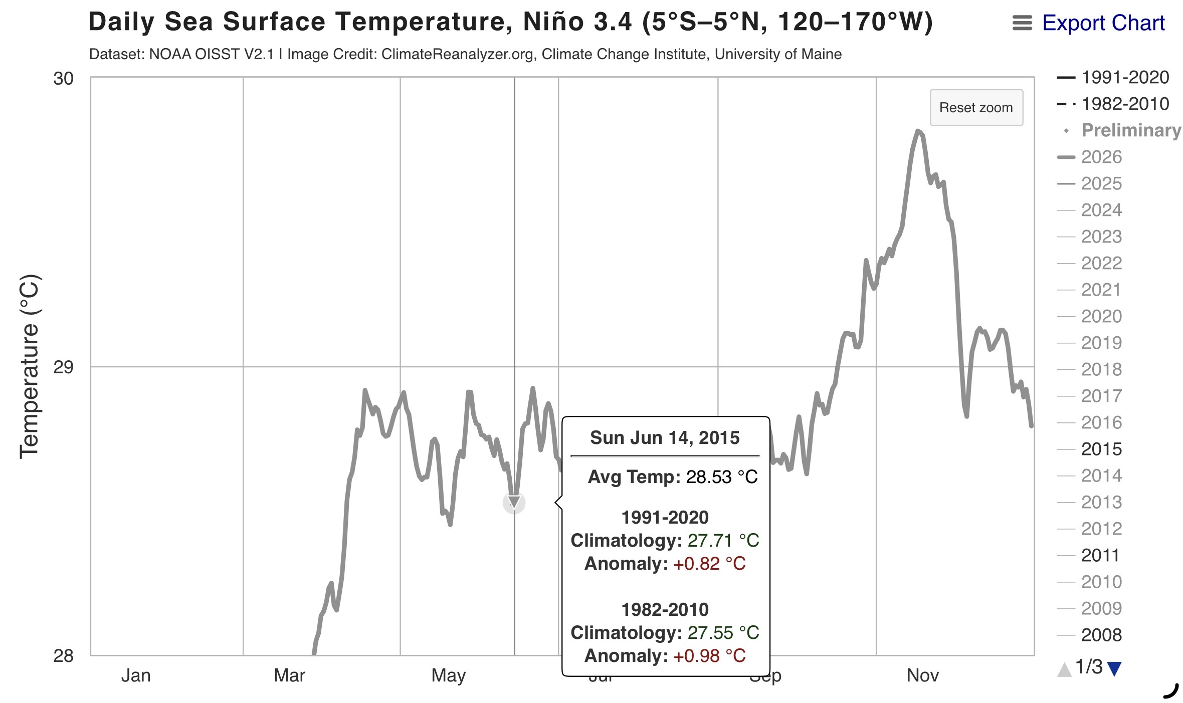
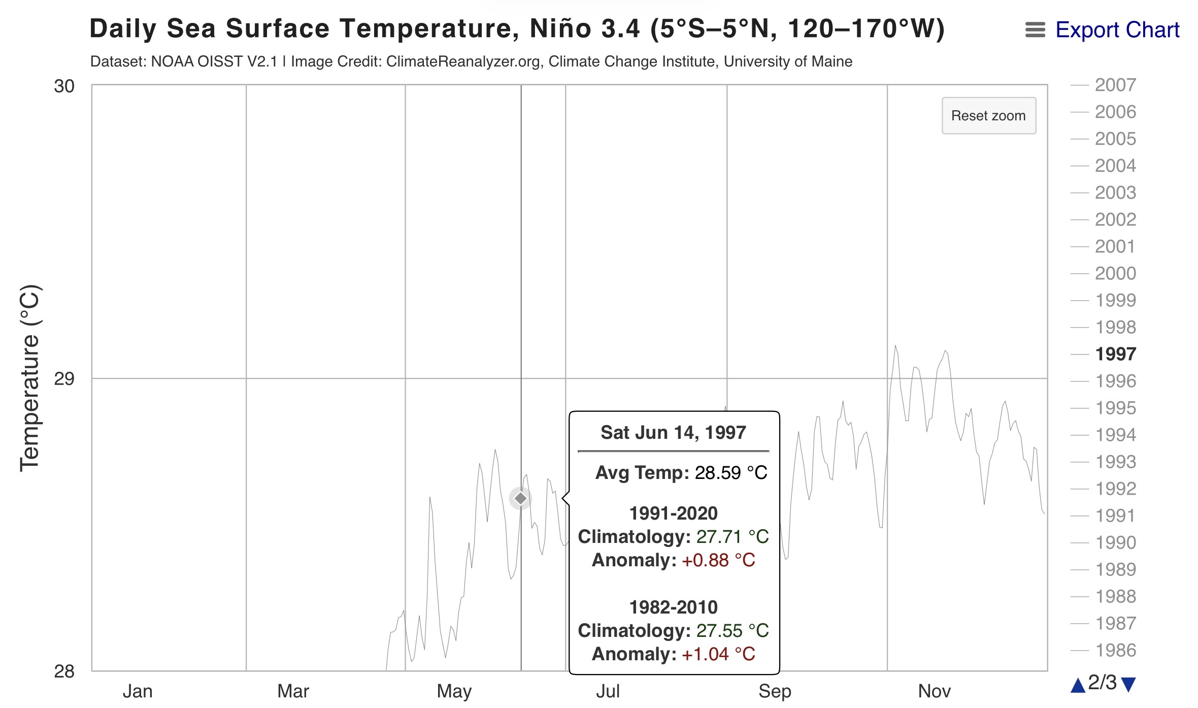
Impressive and record breaking Nino 3.4 lead over 2016 and 1997 for June 14th at 29.32C or +1.61 C.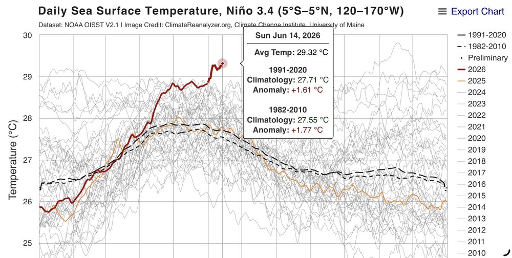


-

2026-2027 Super El Nino
GaWx replied to Stormchaserchuck1's topic in Weather Forecasting and Discussion
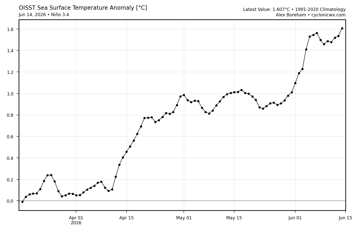
The latest OISST 3.4 1991-2020 anom of +1.607, which is for June 14th, is the warmest for this Nino to date and is ~0.075C warmer than that for June 13th making it the largest warming for any day since June 5th:
-
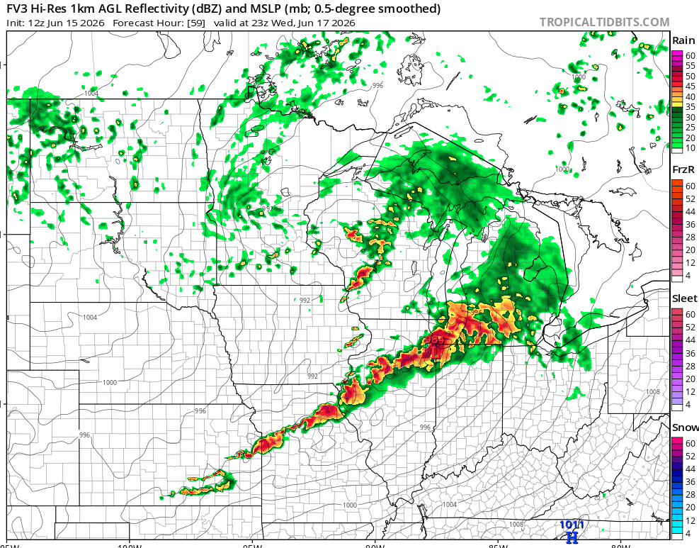
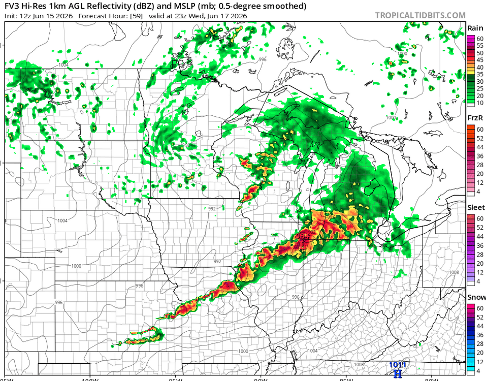
Looks like a classic Illinois day on Wednesday. Parameters are high, and that could all go into a windstorm, but I have to favor supercells initially. So far looks like morning rain will scoot out and leave a lovely outflow boundary with which to work. Factors that should get a big ol' bow echo going are WAA at 850 / 700 mb, 500 mb orientation / height falls, deepening sfc low, high instability, and an east-west boundary (outflow). That said, barring a quick mess, I'm thinking Illinois will book another tornado day. Models line up with the morning rain pattern recognition. In this case looks like it gets away in plenty of time to reheat. Outflow boundary OFB will locally enhance low-level shear. Some of the soundings are little skinny, but that may be a result of temperature forecast uncertainty. Should be skinny north of the OFB, probably fatter south of it. Both sides the LI is robust. Should get supercells along both the synoptic boundary and outflow. As usual we favor the boundary intersection. Also as usual, exact strategy will be a game time decision. Right on the intersection, or 1-2 cells east of it. Back on Thursday I believe the cyclical beast of the day was east of the main triple point, but on another differential heating boundary. Time will tell how Wednesday goes. From pattern recognition I infer initial tornadoes, perhaps 1-3 cyclical supercells. Then it will congeal into quite the bow echo.
-
According to this database (still seemingly updated), it would be record-breaking or nearly so for June once it gets into the lower GL region. Per the map below, record low pressure in June from Chicagoland into the central portion of the lower peninsula of michigan is ~992-993mb https://www.wpc.ncep.noaa.gov/research/roth/SLPrecords.html
-
2026-2027 Super El Nino
GaWx replied to Stormchaserchuck1's topic in Weather Forecasting and Discussion
I see only 1979+ in the table. Based on it, the 2026 rise from MA to AM of 0.9C (-0.6 to +0.3) is the biggest rise for MA to AM since at least 1979. The previous biggest was the 0.7C of 2015: https://psl.noaa.gov/enso/mei/ -
Perfect day out there-AC off and windows open. 74 here
-
-
Could be some great radiational cooling tonight into the upper 40s at usual radiational cooling spots.
-

E PA/NJ/DE Summer 2026 Obs/Discussion
Birds~69 replied to PhiEaglesfan712's topic in Philadelphia Region
72F/DP 55F < 100 days...
-
Feels great with the dewpoints down in the high 40s. We'll have the brief humidity spike on Thursday with the chance of a t-storm, but then right back to very low humidity next weekend. The negative is very little chance of rain with so much low humidity, so the drought will continue to get worse. But a lot of beautiful weather ahead.
-

Central PA Summer 2026 Discussion/Obs Thread
mahantango#1 replied to Voyager's topic in Upstate New York/Pennsylvania
Hopefully we will get some meaningful rain with this event. -
Thats called a Magic Funnel. It was always there until the smokestack made it "appear". Amaze your friends, only 19.99. But wait there's more.... lmao Pretty cool though
- Today
-
What a beautiful day. I'm going to use my "I'm the boss card" and take the afternoon off. I'm meeting a friend for an afternoon hike. It will probably involve a moderate strength edible. Hopefully Thursday is active. I might use my card again and find a good view.
-
yeah we're dialed in good
-

2026-2027 Super El Nino
snowman19 replied to Stormchaserchuck1's topic in Weather Forecasting and Discussion
@GaWx Is the current MEI rise from March through May actually the biggest rise on record for that index like I’m reading on twitter? I only have the data through 1979 right now -
2.4 earthquake in the Bel Air area around 11am. Didn’t feel anything at my house but places to my east in Balt Co did per Facebook
-
Yeah, 49 when the dog took me for an unexpected walk around 6am. I already packed away my sweatshirts. Grabbed a Carhardt out of the closet and ended up sweating lol. Top tier next 7 days except for the frequent rain chances. Rubber band weather.
-
Keeping the early 90s grunge theme? Black hole sun??
-

super el nino banter thread
A-L-E-K replied to forkyfork's topic in Weather Forecasting and Discussion
this super will be beginning of the end for the ole easternuswx weenie set -
I think it's one of those days where satellite is lying everywhere. There's more black than white on vis looping yet I'm getting something like 1/4th sun per hour
-
0.35” here, only 0.45” for the month. Beautiful outside.