All Activity
- Past hour
-

Nov 28-30th Post Turkey Day Wintry Potential
HillsdaleMIWeather replied to Chicago Storm's topic in Lakes/Ohio Valley
DTX is gonna have to go from no headlines to warnings at this point -
Active right out to hr360.
-

December 2025 Short/Medium Range Forecast Thread
Carvers Gap replied to John1122's topic in Tennessee Valley
Glad to have you back, man!!! -

Nov 28-30th Post Turkey Day Wintry Potential
sbnwx85 replied to Chicago Storm's topic in Lakes/Ohio Valley
WSW up. I never dreamed November would produce another big dog this year after the 10" lake-effect event three weeks ago, but here it is. Some areas to my immediate northeast will have 18" on the ground thanks to last night's lake event. -
Call it what you want but let's not pretend this was a big storm

-

December 2025 regional war/obs/disco thread
HoarfrostHubb replied to Torch Tiger's topic in New England
Yeah... I like that second system -
Low of 16 this AM. Coldest of the season. Snow depth 3”
-

Nov 28-30th Post Turkey Day Wintry Potential
Stebo replied to Chicago Storm's topic in Lakes/Ohio Valley
I don't think the negative lake influence will be as prevalence as some models show. -
Yes, there’s research out there that the Indo-pacific warm pool can contribute to western ridging/eastern trough, sometimes even independent of ENSO. Lots of research out on this topic: https://journals.ametsoc.org/downloadpdf/view/journals/clim/29/22/jcli-d-16-0145.1.pdf https://repository.library.noaa.gov/view/noaa/48389/noaa_48389_DS1.pdf
-
What a weenie 12z Euro run.
-

December 2025 regional war/obs/disco thread
weathafella replied to Torch Tiger's topic in New England
Look fellas. I’m old man winter and feeling strong. Gas up the blowers. -
If the WB 12Z Euro comes anywhere near verifying, the metro area can have the next two storms;
-
December 2025 regional war/obs/disco thread
HoarfrostHubb replied to Torch Tiger's topic in New England
He is busy deleting 10s of thousands of not so family friendly posts -
https://tenor.com/bcqd4.gif
-
I may need to change your dad’s name to Messwx
-
 12z/28 ECAI OPPPPP took a big step north in concert with its prior cycle ensembles. EC op has tiny touch of snow acc Tuesday night in the storms departure on w and n LI... garbage but maybe it will be something? Plan for less and enjoy mPing if its provides hope Tue AM and Tue night. Four days away so still model adjustments will occur. n/c to threadline attm.
 -
We can reel this down to us. Plenty of time to manifest it.
-
Now you will know why dad burned the Christmas tree on the 2nd of December.
-

E PA/NJ/DE Autumn 2025 Obs/Discussion
RedSky replied to PhiEaglesfan712's topic in Philadelphia Region
Ai euro sounds similar to the op -

December 2025 regional war/obs/disco thread
40/70 Benchmark replied to Torch Tiger's topic in New England
What a first post. -
That December 2018 storm was amazing. We got 17" up here out of that.
-
Scooter goes G rated...
-

Central PA Fall Discussions and Obs
canderson replied to ChescoWx's topic in Upstate New York/Pennsylvania
Look like some intense squalls NW of State College -
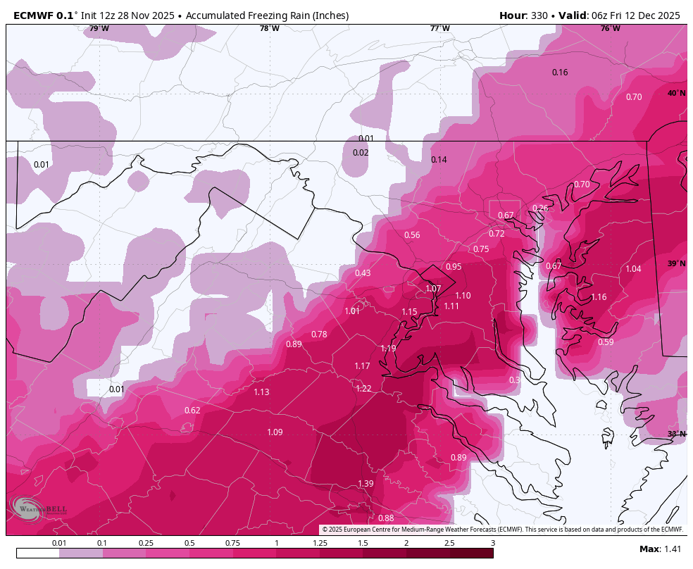
It’s soooo close for DC. Still wicked - 28 and ice. 10” if you don’t go too far NW. All I care about for now is more to track for the next 10 days.

-
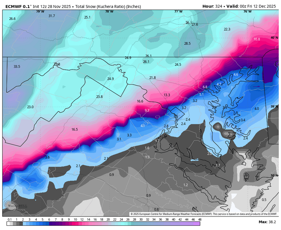
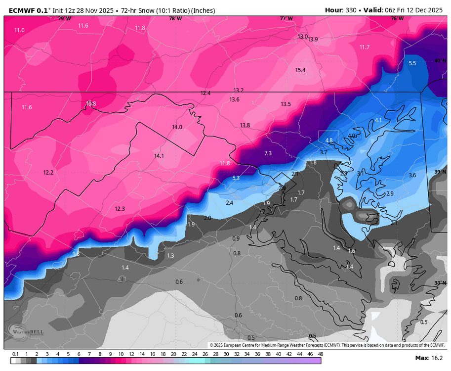
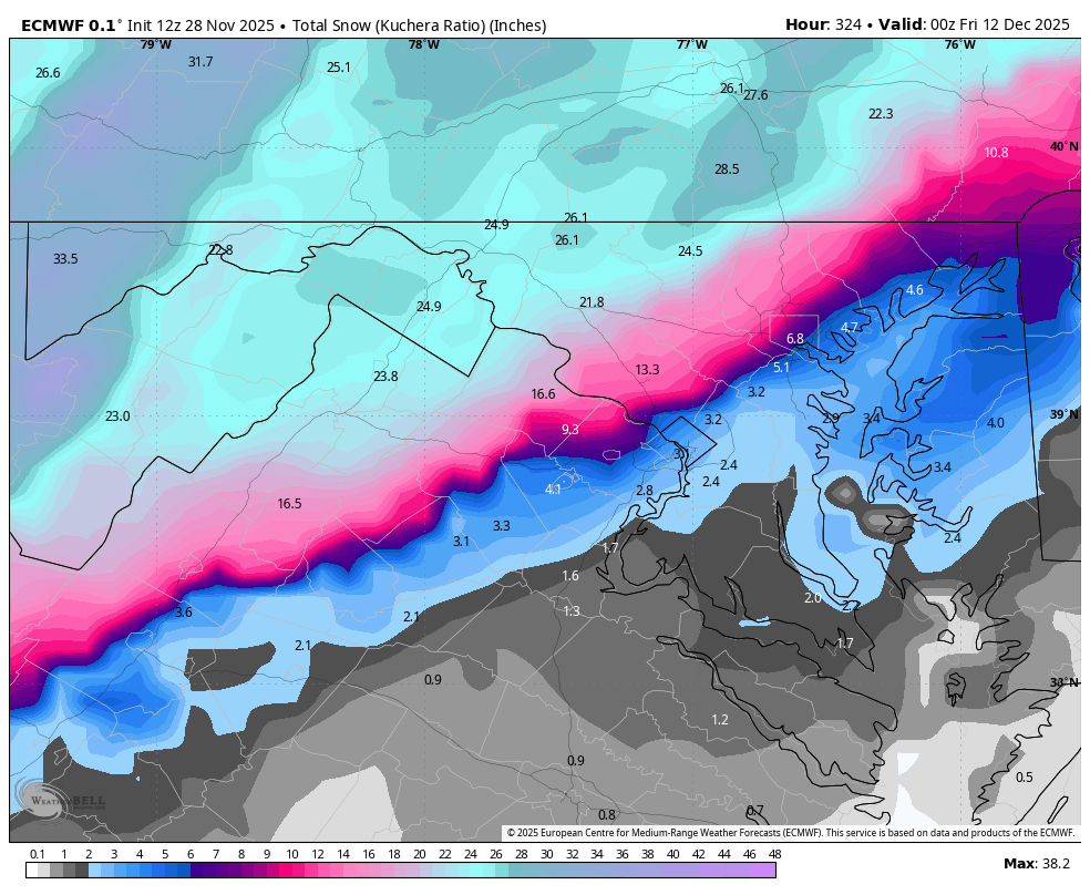
Kuchera for better or worse.
.thumb.png.302dd78135f87ec165a2931c1211b48f.png)


.png.c8e7b9f9fe413229d50a84b3601f56dc.png)