All Activity
- Past hour
-
Juneau is stealing your snow https://archive.ph/Ajhsr
-
January was a nice reminder we still can get sustained winter conditions around here but overall boring weather year IMO. As other have said late summer was a nice treat. Not quite 2014 level but close. The last 90+ degree day at CHO this year was Aug 17!
-

January 2026 regional war/obs/disco thread
Brian5671 replied to Baroclinic Zone's topic in New England
topped out at 47 here-alot of it melted today still about 60% coverage -
Pretty good look pattern coming up. I think some in the forum score...even if just a light event. I mean there are kind of two camps: a big dog or just bunches of small, northern events.
-
It's too bright out there. Bring back the clouds!
-
I legit am kicking around trying to find my way to the Sierra Nevadas (sooner than later) for an atmospheric river event. Vegas flights are cheap, but the drive....Reno is the best, but the connectors can be a problem.
-
Good to have you back in here, man!!! Hopefully you are feeling better. It looks like we are gonna be needing u very soon w/ the pattern shaping up. The real story right now(in addition to the Jan 11-21 window), is the sharp cooking across ensembles d10+. It wasn't there this morning. But -10 to-15 departures at this range is interesting. I gotta think some type of blocking is showing up...maybe a slower moving retrograding high, less prominent SER, OR as I suspect, the air mass in central Canada is gonna be legit and run the show.
-

January 2026 regional war/obs/disco thread
Ginx snewx replied to Baroclinic Zone's topic in New England
Credit card. Hard to believe any adult person not having an ice scraper in New England though -
 Hey Don - you might find this interesting ... https://phys.org/news/2026-01-north-pacific-winter-storm-tracks.html ...statements in there that speak pretty specifically relating to the increasing temperature tendencies/'why' amid the Southwestern regions of the conus.
 -

Central PA Winter 25/26 Discussion and Obs
Itstrainingtime replied to MAG5035's topic in Upstate New York/Pennsylvania
Happy birthday Jon! -
January 2026 regional war/obs/disco thread
Typhoon Tip replied to Baroclinic Zone's topic in New England
https://phys.org/news/2026-01-north-pacific-winter-storm-tracks.html "The findings add to a series of Chemke's previous studies pointing to a troubling pattern: Earth's storm tracks are changing rapidly, and climate models don't always account for that." No shit ... i missed my calling. -

Central PA Winter 25/26 Discussion and Obs
paweather replied to MAG5035's topic in Upstate New York/Pennsylvania
Happy Birthday @sauss06 -

2025-2026 ENSO
donsutherland1 replied to 40/70 Benchmark's topic in Weather Forecasting and Discussion
It will be interesting to see how this plays out. During the 2016-2017 weak La Niña event, which collapsed in January, there was also a powerful WWB. Indeed, the SOI plunged to -33.54 on January 19th. It remains to be seen if that WWB will actually be rivaled, much less surpassed. The 2016-17 La Niña had two days in January where the SOI was -30 or below. No other La Niña event had even one. However, daily SOI values only go back to 1991. February 2017 was truly a "torch" in much of the eastern half of the U.S. I'm not expecting anything along those lines. But the idea that a cold or very cold outcome for February is a "slam dunk" following a powerful January WWB should it occur as modeled, is probably too simplistic. As noted above, 2016-17 saw the opposite outcome. A rapidly weakening La Niña would become less of a factor in influencing patterns. As that happens, other variables, many of which cannot be forecast at current lead times, will gain importance. This competition among variables could lead to large variability on a week-to-week basis. The changeable outcome on the extended range of the ECMWF weeklies may be offering an early hint of that variability. For now, at least based on past late-stage weak La Niña events, the best chances for monthly cold anomalies likely are the Plains States, Great Lakes Region, and eastward into the Northeast. Cold anomalies from the Southwest eastward through the Southeast would be far less likely. -
Might get my wish in about a week.
-
I mentioned a few days ago we do a really good job of kicking the can. The other thing we seem to do well in the mid-south is whiff when the pieces of the puzzle on a large scale line up. We've at least gotten past kicking the can for the ridge of doom in the Aleutians. Now to see if we can buck the second thing we are good at between Jan 15 and 25th. I'm cautiously optimistic.
-

January 2026 regional war/obs/disco thread
WinterWolf replied to Baroclinic Zone's topic in New England
How’d the EPS/Ensembles look after mid month today? -

January 2026 regional war/obs/disco thread
Brewbeer replied to Baroclinic Zone's topic in New England
37/34 here, snow and ice is mostly gone from paved surfaces -
It would be our luck.
-

Winter 2025-26 Medium/Long Range Discussion
sbnwx85 replied to michsnowfreak's topic in Lakes/Ohio Valley
Yea i think it might be at least setting the table for a threat. Baby steps. -

January 2026 regional war/obs/disco thread
metagraphica replied to Baroclinic Zone's topic in New England
Lots of mid 40's temps in the SW part of CT. Still stuck at 37 here. Melting but was hoping for more. -
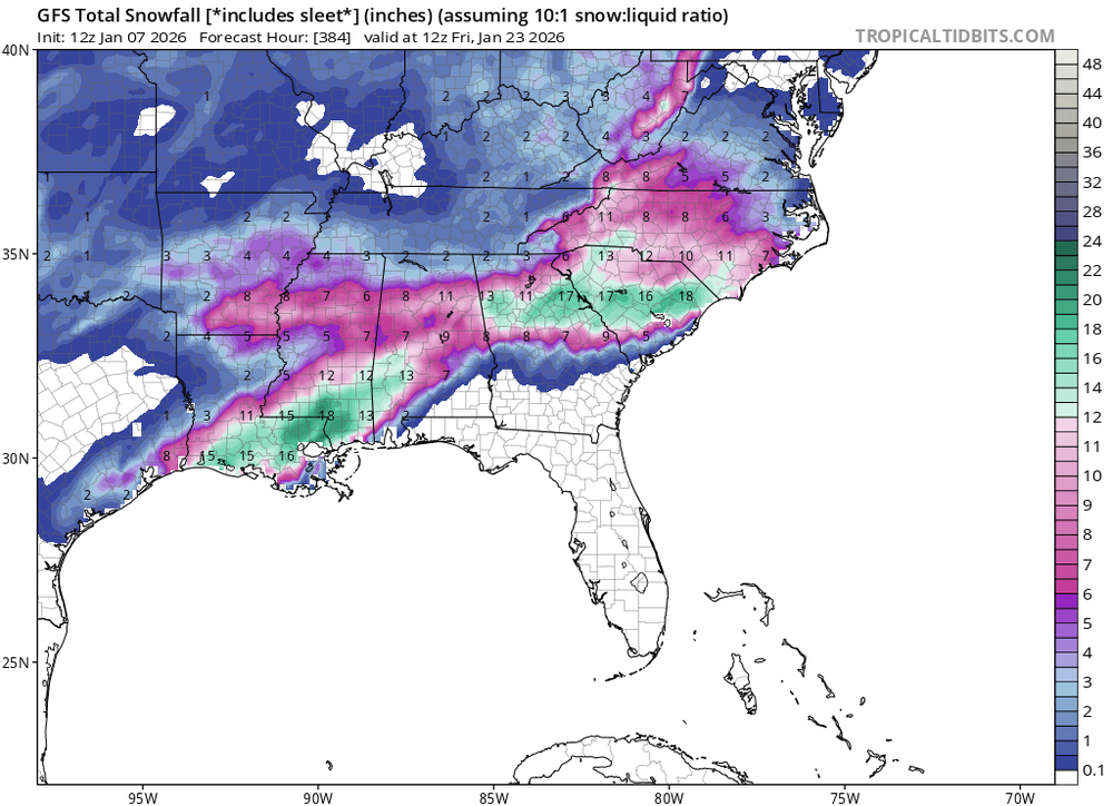
GREAT MOMENTS IN "includes sleet"
-
Looking at 4Season’s data, maybe 9” was the most I had in 1 storm last season
-
61 at home, 75 in Dallas (work travel)
-

January 2026 Medium/Long Range Discussion
SomeguyfromTakomaPark replied to snowfan's topic in Mid Atlantic
It's still early but I feel like it's probably time to punt the Jan 15 window. I guess if a storm perfectly bombed out at our latitude we could maybe get a paste bomb but its like 40 degrees in Montreal during the window. Not a good sign when the freezing line is north of the Adirondacks. -
He's not yet. He just, in another tweet, basically was hinging that Greenland Blocking was why, lol. Of course, as we know, strong Greenland Blocking can mitigate even strong warm MJO effects. However, from Larry's research that is not what the reason was but, something to do with La nina and the location of it, if I remember correctly.


