All Activity
- Past hour
-

Jan 30th-February 1st 2026 Arctic Blast/ULL Snow OBS Thread.
Silas Lang replied to John1122's topic in Tennessee Valley
Lots of small flakes falling here in Inskip neighborhood in Knoxville. -

Jan 30th-February 1st 2026 Arctic Blast/ULL Snow OBS Thread.
Daniel Boone replied to John1122's topic in Tennessee Valley
3/4" here now with with lt to moderate Snow. Temp. 26. -

Jan 30th-February 1st 2026 Arctic Blast/ULL Snow OBS Thread.
fountainguy97 replied to John1122's topic in Tennessee Valley
Wow. Just like that. Not a flake to big nickels pouring out of the sky. 30.5 -

Richmond Metro/Hampton Roads Area Discussion
jlewis1111 replied to RIC Airport's topic in Mid Atlantic
18z Goofus running lets see -

Arctic Hounds Unleashed: Long Duration Late January Cold Snap
dendrite replied to WxWatcher007's topic in New England
MAV mins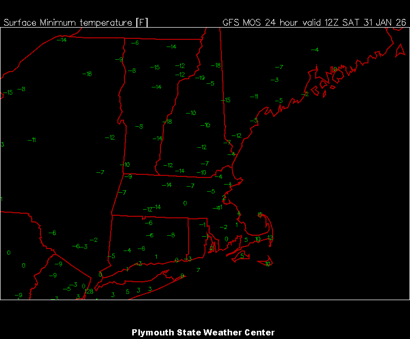
-

Richmond Metro/Hampton Roads Area Discussion
Deep Creek replied to RIC Airport's topic in Mid Atlantic
The extra 4 hours are devoted to making all the incomprehensible intersecting lines on his forecast maps. -
Geez, need to get out to mid February before there’s any real break from the cold. That would be torture if we couldn’t pop a storm or two.
-

The “I bring the mojo” Jan 30-Feb 1 potential winter storm
NEGA_Dawg replied to lilj4425's topic in Southeastern States
Looks good. -
Richmond Metro/Hampton Roads Area Discussion
jlewis1111 replied to RIC Airport's topic in Mid Atlantic
That means 11pm lol ha -

The “I bring the mojo” Jan 30-Feb 1 potential winter storm
franklin NCwx replied to lilj4425's topic in Southeastern States
Lol..I assume you're at the tip of the screw? -

Jan 30th-February 1st 2026 Arctic Blast/ULL Snow OBS Thread.
IndTenn replied to John1122's topic in Tennessee Valley
There is about 3/4 inch on grassy and elevated surfaces imby, but until a few minutes ago nothing on concrete. Now the flake size has increased and it's sticking everywhere. Temp 28 dp 22. -

January 30th- Feb 1st ULL and coastal storm obs
WinstonSalemArlington replied to JoshM's topic in Southeastern States
Flurries have begun in Boone -

The “I bring the mojo” Jan 30-Feb 1 potential winter storm
eyewall replied to lilj4425's topic in Southeastern States
-

West Central Florida Jan 31 - Feb 1 Winter Event
Newman replied to TPAwx's topic in Southeastern States
Looking forward to this cold here in Tallahassee. Might take a nice long walk Sunday morning in the single digit wind chills ha. The 3k NAM continues to show a Gulf effect snow band setting up across Pasco and northern Hillsborough counties around 10-11pm tomorrow. I'm excited to see the potential MCAO cloud streets across the Gulf on satellite imagery. That's something you don't see everyday! -

1/30-1/31 Lake Effect Snow Threat - SE WI, NE IL, and NW IN
DocATL replied to A-L-E-K's topic in Lakes/Ohio Valley
I was a disbeliever but have seen the light. These are the best quality flakes since the famous storm of Early December 2025. -

The “I bring the mojo” Jan 30-Feb 1 potential winter storm
Grayman replied to lilj4425's topic in Southeastern States
Like I said, I’m an amateur and I’m not sure how to look at that based on that link he posted. Feel like putting me through school real quick. I assume that’s bad news. -

Jan 30th-February 1st 2026 Arctic Blast/ULL Snow OBS Thread.
Windspeed replied to John1122's topic in Tennessee Valley
Cranking heavy snow here just south of Bristol. Big fatties. Ground is white. Starting to cover driveway and road. -
The “I bring the mojo” Jan 30-Feb 1 potential winter storm
NEGA_Dawg replied to lilj4425's topic in Southeastern States
Elbert County. -

The “I bring the mojo” Jan 30-Feb 1 potential winter storm
kanc2001 replied to lilj4425's topic in Southeastern States
Analog for Columbia SC is Feb 2010? -
-

The “I bring the mojo” Jan 30-Feb 1 potential winter storm
AGardiner87 replied to lilj4425's topic in Southeastern States
Chris Justus’s updated map!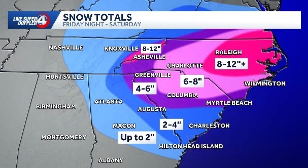
-
 A couple of thoughts about the most recent 3km NAM: I don't think the NAM is seeing the Bays mt band we've seen in the past from NW flow, but that is an interesting enhancement streak in accums. with regard to the Bays Mt. band's typical location.
 -

February 2026 Medium/ Long Range Discussion: Buckle Up!
Heisy replied to Weather Will's topic in Mid Atlantic
It’s the icon so it doesn’t mean a whole lot, but this run would have been pretty nice for mid Atlantic. Confluence relaxed. Let’s start happy hours off right -
Ha, over here in the deepest part of the Buncombe snow hole, lol
-
The “I bring the mojo” Jan 30-Feb 1 potential winter storm
franklin NCwx replied to lilj4425's topic in Southeastern States
You're in rabun county?

.thumb.png.4150b06c63a21f61052e47a612bf1818.png)