All Activity
- Past hour
-
Holy crap…… Thursday Sunny and hot, with a high near 103. West wind 5 to 8 mph. Thursday Night Mostly clear, with a low around 76. West wind 3 to 5 mph. Friday Sunny and hot, with a high near 101. Northwest wind 3 to 8 mph.
-
Some great Miami style nights coming up. Forecast low temperatures in the lower 80s across NE NJ and NYC Thu night and Fri night. Heat index values not expected to drop below the lower 80s in NYC and immediate surrounding areas Wed night through Fri night, making for little to no recovery from heat stress Wed through the day Sat.
-

Central PA Summer 2026 Discussion/Obs Thread
pawatch replied to Voyager's topic in Upstate New York/Pennsylvania
63 degrees this morning with yesterday’s high of 75 degrees. We picked up .20” of rain yesterday. It’s been kind of hit and miss. Sometimes just getting skirted by the bulk of the storm. But at lest picking up some rain. Looks like Tuesday we see our start of the heat. Then 3 days of close to 100. Looks like the AC will be getting a good workout. Probably just stay inside them 3 days. -

E PA/NJ/DE Summer 2026 Obs/Discussion
Hurricane Agnes replied to PhiEaglesfan712's topic in Philadelphia Region
I know this won't be welcome in this group - Picked up 0.09" of rain yesterday for 6.25" for the month so far, and had a high of 76 after a 68 low. Currently 69 with dp 67. - Today
-
Forget all your typical heatwave songs. Time for us to enjoy the summer like the manly men we are. Anyone got an extra scooter? We’re in this for a while better make the best of it lol
-
It's showing 105 degrees for Friday. That would be... something.
-

Late May/June 2026 Medium/Long Range
Stormchaserchuck1 replied to JenkinsJinkies's topic in Mid Atlantic
Baltimore city forecast Thursday Sunny and hot, with a high near 106. Thursday Night Mostly clear, with a low around 81. Friday A slight chance of showers and thunderstorms. Sunny and hot, with a high near 106. Chance of precipitation is 20%. -
2026-2027 Super El Nino
Stormchaserchuck1 replied to Stormchaserchuck1's topic in Weather Forecasting and Discussion
Good chance for an -AO this Winter in my opinion! The correlation to reverse conditions there between the warm and cold seasons has been strong since 2012! I think the period looked at is through September though. -
2026-2027 Super El Nino
Stormchaserchuck1 replied to Stormchaserchuck1's topic in Weather Forecasting and Discussion
That's the NAO. I think the folder code is always pna. Here's PNA: cpc.ncep.noaa.gov/products/precip/CWlink/pna/norm.pna.monthly.b5001.current.ascii.table -
Need this here. Nearly 30k bolts detected in 30 minutes lol
-
My response to calls to bring back Showalter specifically: Hypothetically speaking...Bring Showalter back and then what...still not win a WS that we all want? Lol Sure the regular season may go better...but we would still not have a ring as Showalter fell short in the playoffs his entire career. So that would be a no for me!
-
Tell me can you feel it?
-
Just checked myself and had to do a double-take. Would be the hottest weather in 14 years.
-
The 12Z UKMET had nothing of note, even less than yesterday’s 0Z’s very weak low hitting near Daytona Beach. But the new 0Z is the 1st of its runs with a TD transitioning from an extratropical low that forms on a front. It then moves WSW but remains weak and then gradually weakens followed by dissipation on Thu well off the SE coast: MET OFFICE TROPICAL CYCLONE GUIDANCE FOR NORTH-EAST PACIFIC AND ATLANTIC GLOBAL MODEL DATA TIME 0000UTC 28.06.2026 NEW TROPICAL CYCLONE FORECAST TO DEVELOP AFTER 54 HOURS FORECAST POSITION AT T+ 54 : 32.1N 71.8W LEAD CENTRAL MAXIMUM WIND VERIFYING TIME TIME POSITION PRESSURE (MB) SPEED (KNOTS) -------------- ---- -------- ------------- ------------- 1200UTC 30.06.2026 60 32.1N 70.7W 1011 26 0000UTC 01.07.2026 72 31.2N 71.3W 1012 25 1200UTC 01.07.2026 84 30.4N 71.5W 1013 25 0000UTC 02.07.2026 96 30.5N 72.7W 1015 22 1200UTC 02.07.2026 108 30.6N 74.3W 1016 16 0000UTC 03.07.2026 120 CEASED TRACKING
-

2026-2027 Super El Nino
GaWx replied to Stormchaserchuck1's topic in Weather Forecasting and Discussion
Those are the NAO values, not PNAs. -

2026-2027 Super El Nino
PhiEaglesfan712 replied to Stormchaserchuck1's topic in Weather Forecasting and Discussion
The values show -PNA for 09-10, unless this whole thing is wrong: https://www.cpc.ncep.noaa.gov/products/precip/CWlink/pna/norm.nao.monthly.b5001.current.ascii.table -
70/70
-
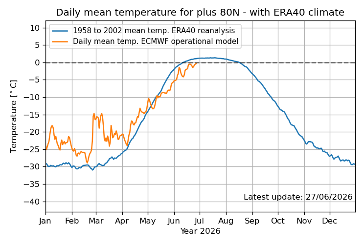
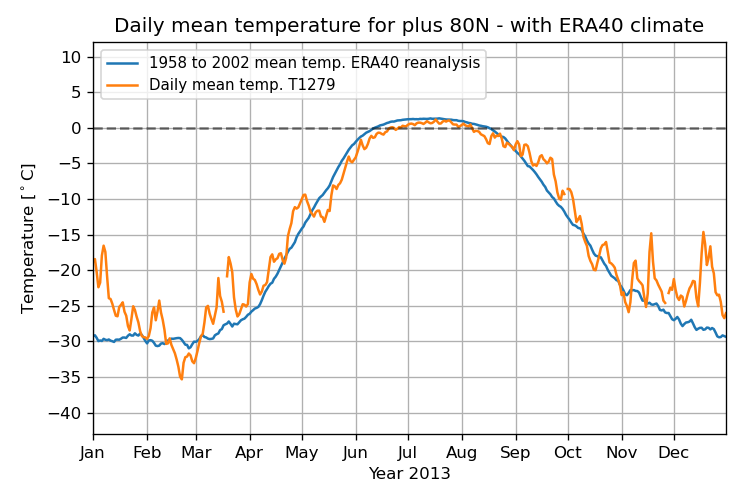
Per DMI, the daily mean temp in the Arctic N of 80N has still not reached 0C! As of today (6/27), it’s still barely <0C at -0.35C: Going all of the way back to 1958, the previous latest to first exceed 0C was a full week earlier, June 20th, and that was in 2013: So, even if it finally exceeds 0C tomorrow, that would still be a whopping 8 days later than the previous latest on record of June 20th! I checked every year. https://ocean.dmi.dk/arctic/meant80n.uk.php
-
2026-2027 Super El Nino
GaWx replied to Stormchaserchuck1's topic in Weather Forecasting and Discussion
Per DMI, the daily mean temp in the Arctic N of 80N has still not reached 0C! As of today (6/27), it’s still barely <0C at -0.35C: Going all of the way back to 1958, the previous latest to first exceed 0C was a full week earlier, June 20th, and that was in 2013: So, even if it finally exceeds 0C tomorrow, that would still be a whopping 8 days later than the previous latest on record of June 20th! I checked every year. https://ocean.dmi.dk/arctic/meant80n.uk.php

-
Just before a June full moon is jumbo season. Last year’s mudders
-

E PA/NJ/DE Summer 2026 Obs/Discussion
Birds~69 replied to PhiEaglesfan712's topic in Philadelphia Region
Was thinking the same and almost guarantee Philly will stay above 80F for overnight lows for at least 1 and probably more nights... -
Are you petrified?
-
Yes...I am from there...during floyd rescued the neighbors labradors from flooding. Lake Wilson rd...across the street
-

E PA/NJ/DE Summer 2026 Obs/Discussion
JTA66 replied to PhiEaglesfan712's topic in Philadelphia Region
Wouldn’t be surprised to see those overnight “lows” bump up. I imagine PHL records an overnight low of 80F or more next week. Only a T in the bucket today. Driest super El Niño ever. -
Had a few storms pop up here today, not much in the rain gauge. .13 fell here. And again now that I moved out of my old hood, they got nearly a third of an inch, go figure.


