All Activity
- Past hour
-

“Cory’s in NYC! Let’s HECS!” Feb. 22-24 Disco
ORH_wxman replied to TheSnowman's topic in New England
I think ORH is in as good as a position as anywhere for a great band or two. I’d expect something like 15-25” for a forecast there. 1-2 feet at minimum and you could make a case for Ray’s 18-30”. Being on the east side of the spine there will be an advantage in this storm. It sort of “protects” them a bit more from the dry air intrsution that could try and sneak down the CT valley if you get a situation like Jan 2015 where the real meat of the CCB is a bit east. -
After browbeating anyone who dared suggest a storm for the northern MA.
-
Nice look with the 20" number in NEPA. Offers some credibility on solid amounts getting into NWNJ.
-
Looks pretty similar to the NAM...
-
-

February 22-23 Storm Thread/OBS
PhiEaglesfan712 replied to Mikeymac5306's topic in Philadelphia Region
A cross between 12/26/2010 and 1/28-29/2022 seems the most likely solution. -
Tick deeper h5 and maybe a tick negative or the same. Surface low is pretty much the same.
-

“Cory’s in NYC! Let’s HECS!” Feb. 22-24 Disco
ineedsnow replied to TheSnowman's topic in New England
Ya there's not a mob of people yet! I bet by later today people freak.. btw GFS has another 18 to 24 for some Thursday night and friday -
Ah ok, thanks for the explanation! Sounds like the teleconnection indices mask a lot of smaller-scale features and don't necessarily tell the whole story.
-
Solidly driving very heavy amounts well into the Catskills FWIW.
-
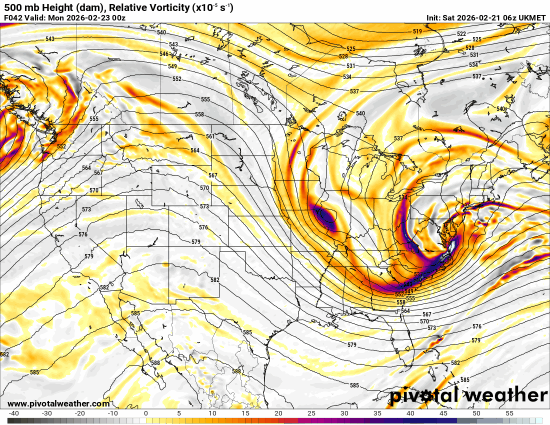
Ukie looks good, coming into alignment here. This would honestly be my "base" snow map as far as spatial coverage of heaviest snows
.thumb.png.cc477cb95c2c4148683497d55a57fef7.png)
-

2/22-23 "There's no way..." Storm Part 2
DDweatherman replied to Maestrobjwa's topic in Mid Atlantic
Just touched on it above, it’s best run thus far. H5 was a nice improvement. -

2/22-23 "There's no way..." Storm Part 2
Stormchaserchuck1 replied to Maestrobjwa's topic in Mid Atlantic
It's not that bad because shorter wavelengths give us a favorable H5 low in the Gulf of Alaska. Our biggest snowstorms historically have that -H5 anomaly -
Updated with UKMET
-
Well he certainly changed his tune!
-

Southern MD / Lower Eastern Shore weather discussion
csnavywx replied to PrinceFrederickWx's topic in Mid Atlantic
Looks like the real McCoy to me for you folks on the Eastern Shore: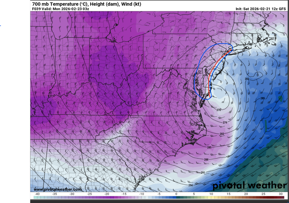
-
Solid event backend. Even OES at the end on the S Shore.
-
Nobody mentioned ggem? Notable west jump vs 0z. Very nice for most of our sub.
-
43.8 we’ve had some big storms after a warm day
-
Feels like people still have no idea this is coming. Last storm the grocery stores in Boston were overrun the day before. Today they were no busier than usual.
-
It’s a +pna and a decaying -nao into Hudson Bay. Pretty standard storm setup. It’s just the loading pattern before could not get a fresh airmass
-

E PA/NJ/DE Winter 2025-26 Obs/Discussion
Physicsteve replied to LVblizzard's topic in Philadelphia Region
Let’s hope it’s on a hot streak. Period has shown potential along with early March. -
I just think the “differences” we’re talking about are because of land vs ocean snow maps more so than the models being all that far apart. If this storm was a cutter we probably wouldn’t even notice it lol.
-

February 22-23 Storm Thread/OBS
coastal front replied to Mikeymac5306's topic in Philadelphia Region
Ukie is tuckeddddd -
Cloudy am with FL. Ice is reforming on Agate bay where the ore docks are located (seen from webcam there). Temps in the sd's inland with 10's along the shore. Those high winds chewed the ice on the Lake pretty good.


.png.6ab0e1e79fb1ad7c7040a9ce50121199.png)


