All Activity
- Past hour
-
To put that into perspective, Cleveland has only seen one May with 4 90+ days (1962); Detroit, 3 times: 1962 (6), 2018 (4), and 1895 (4); and Bristol, Tennessee, twice (1962 & 1941, 6 each). And for those who would blame the latter on elevation, Bristol is actually closer in elevation to International Falls than the other two cities. International Falls looking to shed its title as "icebox of the nation" in a BIG way!
-
Just in time for everyone's outdoor plans for Memorial day. The good thing, is even with below temps it will still be warm for outdoor activities, just not scorching hot, which is nice.
-
The differences between KNYC and Newark are wild in some recent years on those Memorial Day charts. In 2021 for example, Newark was 84 with a low of 66 and Central Park had a high of 70 with a low of 49? That's not possible. And in 2023 Newark was 88/70 and Central Park was 79/59? Something is off.
-
Incredible stuff. Record breaking 4th day at or above 90F yesterday at International Falls. That's the most ever recorded in the month of May, with 17 days remaining in the month.
-
Congrats Bristol RI with 3”
-
Looking at one of the coolest Memorial Day weekends coming up in the last several years. Surf temps near North Wildwood, NJ near 60 F. Hopefully by Father's Day weekend we experience warmer surf zone temps. Meanwhile a large area of High pressure, a heat dome, is building in the very deep South across the Gulf and will cause extreme heat in Texas. No signs of any excessive heat here for several weeks, or more.
-
.49" Duxbury and rising fast.
-
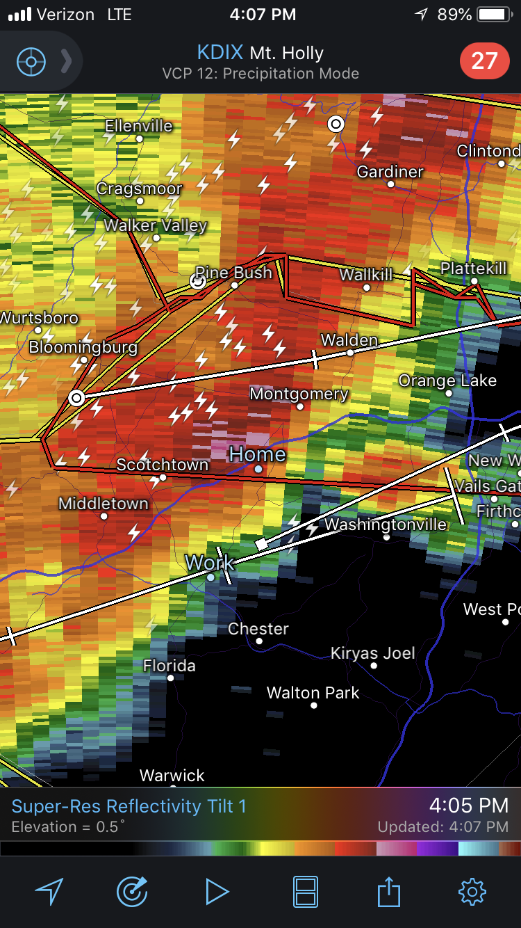
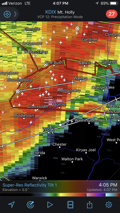
 Enhanced risk expanded slightly south and further east to Detroit, 30% sig wind introduced over Northern Indiana and Southern Michigan. They're expecting mature supercell's ahead of the line so some areas could have a tornado threat and then damaging wind right behind it
 -
Total event for me was 3.35".
-
Yeah, that day. The top of one of my maples got ripped off and clipped the corner of the house causing roof damage and taking out a window. I wasn’t home when it happened but will never forget driving through downed trees and branches and having to walk to get to my house only to find it damaged. Not fun. The cell that went through my area eventually had a confirmed tornado just miles to my east. That day did the opposite for me, I dislike severe weather now. Nor’easters were always the driving force behind my weather interests anyway.
-
 Looks like I'll be heading northwest today and south tomorrow
 -
That better than girls gone wild?
-
Why not


-
 I wouldn’t be shocked if SPC goes moderate risk for the Michiana region. Storms may be more linear by the time they get here but an embedded, strong tornado or two seems like a good bet locally.
 -
Seven years ago today, the derecho that blew through sheared the porch off the house at my old place. Still probably one of the scariest days of my life but the one that re-ignited my weather interests Back to today, 5.30" for the month and more rain incoming the next few days.
-
Weeds went wild yesterday.
-
Thankfully pronouns were abolished several months ago
-
NYC Memorial day Year Memorial Day Date High Temp (°F) Low Temp (°F) Precipitation (in) 2000 May 29 66 52 0.00 2001 May 28 74 59 0.00 2002 May 27 82 65 0.00 2003 May 26 67 53 0.00 2004 May 31 78 60 0.00 2005 May 30 85 66 0.00 2006 May 29 88 70 0.01 2007 May 28 83 67 Trace 2008 May 26 80 58 0.00 2009 May 25 81 63 0.00 2010 May 31 86 69 0.00 2011 May 30 86 70 0.29 2012 May 28 89 71 0.00 2013 May 27 73 51 0.00 2014 May 26 86 66 0.00 2015 May 25 85 64 0.00 2016 May 30 82 68 1.65 2017 May 29 61 56 0.13 2018 May 28 69 56 0.00 2019 May 27 80 64 0.00 2020 May 25 71 55 0.00 2021 May 31 70 49 0.02 2022 May 30 84 63 0.00 2023 May 29 79 59 0.00 2024 May 27 73 66 0.96
-
Memorial Day at EWR Year Memorial Day Date High Temp (°F) Low Temp (°F) Year Memorial Day Date High Temp (°F) Low Temp (°F) Precipitation (in) 2000 May 29 66 52 0.00 2001 May 28 74 59 0.00 2002 May 27 82 65 0.00 2003 May 26 67 53 0.00 2004 May 31 78 60 0.00 2005 May 30 85 66 0.00 2006 May 29 88 70 0.00 2007 May 28 75 58 Trace 2008 May 26 80 62 0.00 2009 May 25 77 60 0.00 2010 May 31 85 65 0.00 2011 May 30 88 68 0.09 2012 May 28 90 70 0.00 2013 May 27 78 60 0.00 2014 May 26 80 62 0.00 2015 May 25 82 64 0.00 2016 May 30 85 66 0.25 2017 May 29 78 60 0.12 2018 May 28 83 65 0.00 2019 May 27 80 62 0.00 2020 May 25 76 58 0.00 2021 May 31 84 66 0.00 2022 May 30 86 68 0.00 2023 May 29 88 70 0.00 2024 May 27 85 67 0.72 2025 May 26 82 65 (TBD)
-

Central PA Spring 2025
Mount Joy Snowman replied to canderson's topic in Upstate New York/Pennsylvania
Low of 61 with .08" of additional rainfall. Three-day total of 1.52" and monthly total of 5.67". Grass is booming, a little bit of sun later today and it's going to explode. -
Its a start....express yourself Rain for he, she, they them and all on MMD weekend.
-
 Ready to get missed twice today.
 -
I suspect the Euro is overzealous ... Mostly for philosophical reasons. Firstly, it's not impossible. In 2002, I saw noodly mangled aggregates mixing in with general cat paw rains with tree swaying NE gusts on May 22nd where I was living at the time, Waltham, Ma. It was carrying on from a storm that looked a lot like what this Euro run was selling on the 00z. So yeah ... it can happen. I just would feel better about that if it were all D4 ...not D8 There's just longer termed ( like years worth actually - ) observation of modeling biases and behavior that would argue the Euro could certainly by over phased at this range - and it is a phased scenario in that run. All models - in fact - are charging the hemisphere with -NAO. The NAO domain overall is not really very well handled by any guidance, particularly out in time. Compounding that aspect is the fact that is still spring, albeit getting into later spring ... but we're still passing through a higher error time of the year. So the short version of this paragraph is that the NAO has to be first very accurately outlooked at a range whence it seldom is, and doing so at a time of the year when it almost never is... Good luck Euro. Plus, it's not different than in January, when the model has a D8 bomb then ... You're better off with hinting of a storm in that range, and then having it emerge into those indicators passing thru D5s ... Having said all that... the trade off is not a balmy glorious time of it. The westerlies are torpedoing later in the year than normal, with lots of vigorous waves propagating coming across the country, while the uncertainties with the NAO ...that does not mean "no" NAO. It just means that how it relates/influences is unlikely to be precisely how the Euro ends up with all that from this range. The 00z/06z GFS blend is probably a better solution with more progressivity and a just keeping things moving along, but the westerlies overall are suppressed S of normal so...it's not sending any warm vibes.
-
Yea, 3-6 panic attacks for Scooter with a 50% chance of MDD.
-
3 day event total 3.58 here. Fog currently and 56.6/55.9.