All Activity
- Past hour
-

“Cory’s in LA! Let’s MECS!” Jan. 24-26 Disco
WinterWolf replied to TheSnowman's topic in New England
We tried to tell him…he wouldn’t listen. He will be cleansed by brimstone and SNOW. -

January 24-26: Miracle or Mirage Thread 2
NorthArlington101 replied to mappy's topic in Mid Atlantic
Thump is wetter thru 6am -
My weather radio just spat out the first alert, game time
-
Consistent with thermals and a touch wetter so far
-
Onset tomorrow from 12z gfs. Sent from my SM-G998U using Tapatalk

-

Possible Record Breaking Cold + Snow Sunday 1/25 - Tuesday 1/27
eduggs replied to TriPol's topic in New York City Metro
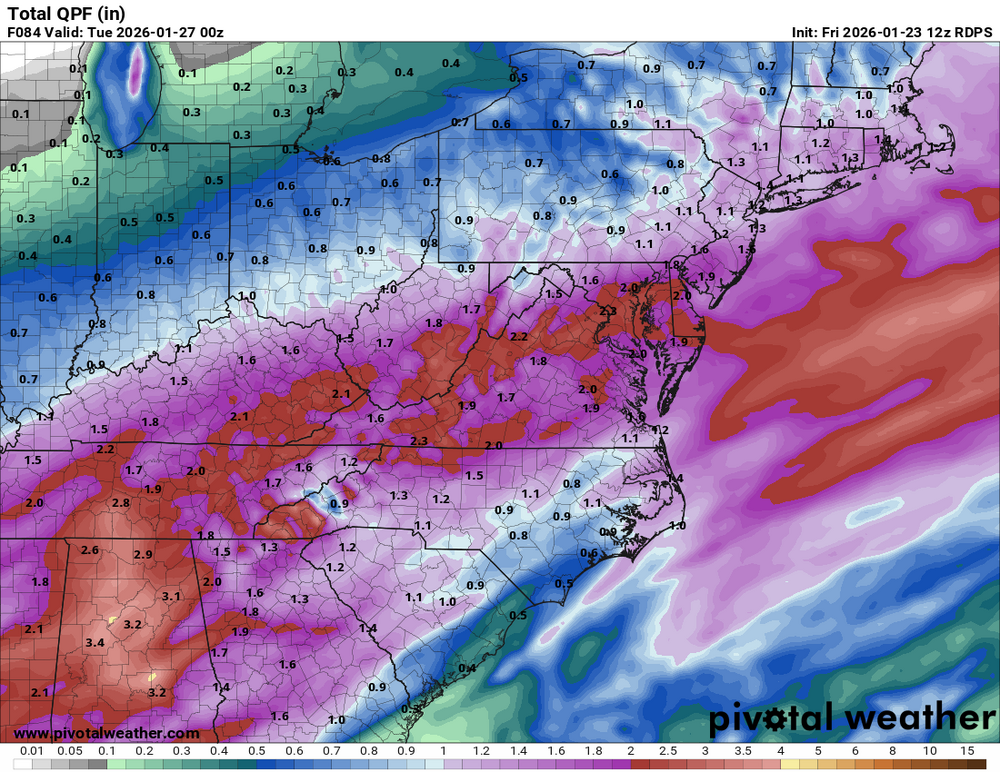
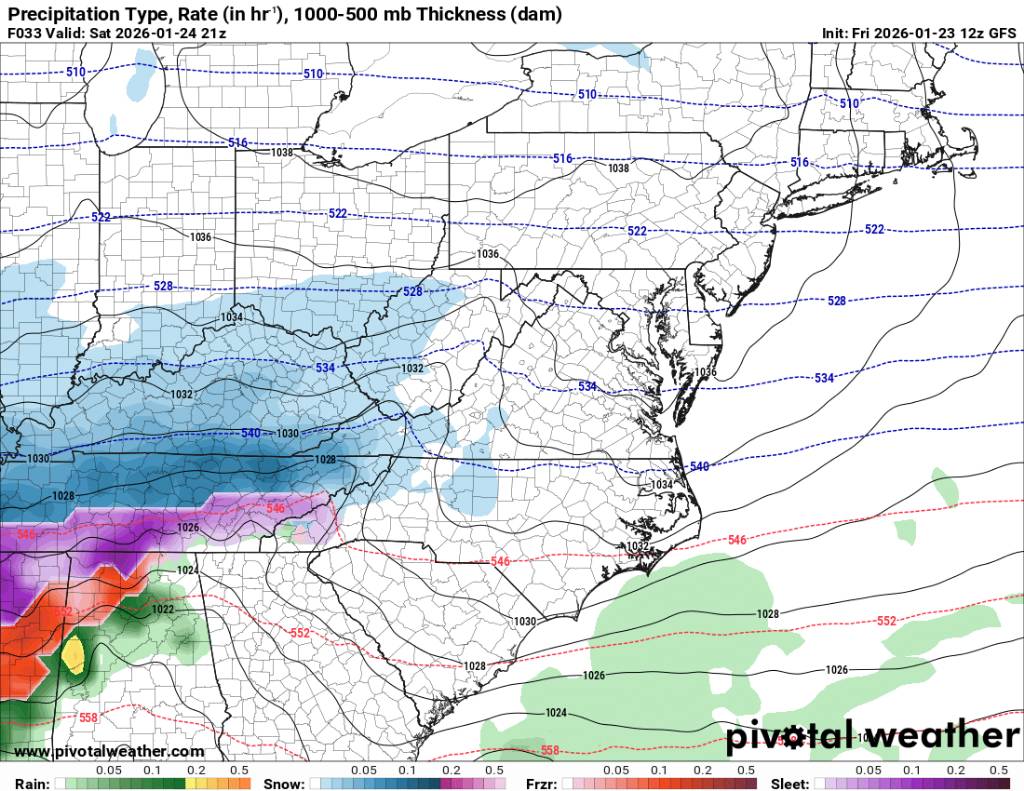
Agreed about the primary - that's key. A weaker, further south primary won't push the dryslot as far north. That could lead to a continuation of light precipitation after the thump into the overnight as opposed to a quick end. The RGEM has been steadily flatting the longwave trof, which would be associated with a weaker primary... but models historically weaken this feature too quickly. -
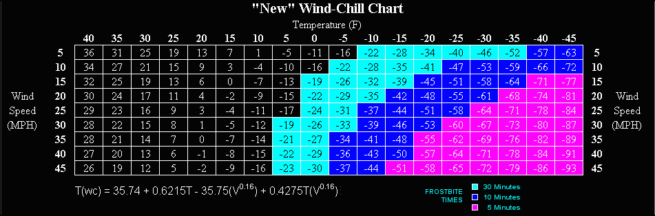
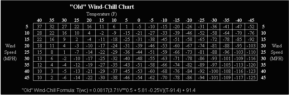
Windchill hit -52 this morning at the TH arpt. Here are the charts for the new n old windchill values. For us older folks, need both for reference
-
looks to be a little more amped on the H5 map
-
 I agree overall it's looked improved.
 -
Today marks a full 10 years since the last 6" storm in Stephens City. An entire decade has passed without a significant snow storm. Truly unbelievable. And awful.
-
Tell me I'm not tweaking... I noticed on this mornings dawg walk that climbing planes from O'Hare sounded comparatively hifi. Even from definitely a few thousand feet up you could hear tarmac-style turbine whine, yk that more shrill sound, echoing loudly off of adjacent apartment buildings quite literally the way it sounds in a terminal. I actually had a hard time finding them because the higher frequency sounds making it farther down are ofc coming when the plane is directly above you, which my monkey brain was not computing properly with how loud the sound was. Even with a clear sky, I just wasn't looking for hoes that far up and was therefore surprised when I realized. Ig I'm just shocked that if it's as simple as cold air = denser = transmits delicate high frequency sound waves better, that it makes such a massive difference between say 20° and -9° compared to 20° and 80°.
-
CPcantmeasuresnow is in a good spot for jackpotting I would guess
-

1/24-1/25 Major Winter Storm - S. IL, IN, MI and OH
mimillman replied to A-L-E-K's topic in Lakes/Ohio Valley
Or you could have this
-
Remarkably consistent, almost carbon copy so far
-
Baja low a little quicker to eject
-

“Cory’s in LA! Let’s MECS!” Jan. 24-26 Disco
40/70 Benchmark replied to TheSnowman's topic in New England
Weenie meso enhancement for you Yea, here we go....subby city. -
Front is blowing thru. Temp is at 34 and it’s windy!
-
SWFE storms are always uniform.
-
This seems plausible with the possibility of that cutoff shifting north or south
-

Possible Record Breaking Cold + Snow Sunday 1/25 - Tuesday 1/27
NEG NAO replied to TriPol's topic in New York City Metro
where is your area ? -
There is a connection; i spent a large part of growing up in Plano- i had mentioned this in a earlier post about N Texas being a good place to monitor with regards to what happens during the initial part of the storm... so keep em' coming
-

Possible Record Breaking Cold + Snow Sunday 1/25 - Tuesday 1/27
psv88 replied to TriPol's topic in New York City Metro
NAM, which the naysayers cling to for mid level warming, popped the secondary earlier and further SE. this ticked the mixing south. Great run of the NAM. the RGEM was less snowy due to a weird QPF min around the city. The ICON has been wildly inconsistent. so far I like the 12z suite -
Icon Icon drops another 3-4" this week too!
.thumb.png.dcc1c9a09eded2937ba66a81cef3c5c3.png)
-
.thumb.png.4150b06c63a21f61052e47a612bf1818.png)
“Cory’s in LA! Let’s MECS!” Jan. 24-26 Disco
HIPPYVALLEY replied to TheSnowman's topic in New England
MPM's stress level heading North as QPF trends South? -

Possible Record Breaking Cold + Snow Sunday 1/25 - Tuesday 1/27
Stormlover74 replied to TriPol's topic in New York City Metro
Yeah it didn't change much other than got drier so looks like less snow. Nam got wetter.


.png.0fbeb7a98d31effe742b881e96de6cda.png)