All Activity
- Past hour
-
“When one has been angry for a very long time, one gets used to it. And it becomes comfortable, like old leather. And finally... becomes so familiar that one can't ever remember feeling any other way.” .
-
some signs of life on the weekend wave with a handful of models now ditching the dampening duster and maintaining a decent wave east into N. IL hope we see more good trends today to keep the streak going
-

December 2025 regional war/obs/disco thread
Kitz Craver replied to Torch Tiger's topic in New England
Nice to see the mid month warm up really muted, hopefully it’s not just waiting for the perfect time… -
Isn’t that a little melodramatic? Not saying you’re wrong, but I think a lot of people would have lost their minds here if they were around for a lot of the 1990s outside of two fun winters. History doesn’t repeat itself, but it often rhymes. .
-
December 2025 regional war/obs/disco thread
Kitz Craver replied to Torch Tiger's topic in New England
Seemed to me like models kinda lost it -

Central PA Fall Discussions and Obs
mahantango#1 replied to ChescoWx's topic in Upstate New York/Pennsylvania
-
Classic north of I-40 storm. Car topper for most. At least it's something!
-

December 2025 regional war/obs/disco thread
Damage In Tolland replied to Torch Tiger's topic in New England
Norlun -
Unfortunately, this map from the WPC says it all.
-
From your post to their ears. If you are ever betting on dates for early snow, 12/5 is always the sweet spot on the roulette wheel.
-
Models have trended warmer overnight.
-

2025-2026 ENSO
PhiEaglesfan712 replied to 40/70 Benchmark's topic in Weather Forecasting and Discussion
After that, do you think the winter returns, or are we going to torch in January and February, like in 2016-17 and 2022-23? -
Cold morning here. 22 degrees.
-
So far since November, we’ve seen -WPO (Aleutian ridge regime) driven cold. This is in contrast to the -EPO (Alaskan ridge regime) driven cold we saw last winter….. @SnowGoose69 @donsutherland1 @bluewave
-
December 2025 regional war/obs/disco thread
Kitz Craver replied to Torch Tiger's topic in New England
Not a horrible GFS run -

December 2025 regional war/obs/disco thread
WxWatcher007 replied to Torch Tiger's topic in New England
Snowing nicely under an Ontario LES band. Arctic front is shaping up behind it. I still think we see some flakes in SNE later, though the signal looks meh verbatim on the guidance. Arctic hounds to arrive later today with falling temps and gusts to 20-30. Radiators mount up later tonight. We’ll see how low we can go…might even get single digits back in CT tonight. -

Pittsburgh/Western PA WINTER ‘25/‘26
TimB replied to Burghblizz's topic in Upstate New York/Pennsylvania
No one, including myself is complaining about a solid advisory level event on the second day of meteorological winter to kick off the season. We’ll still have our chances this season to break the streak, hopefully. -
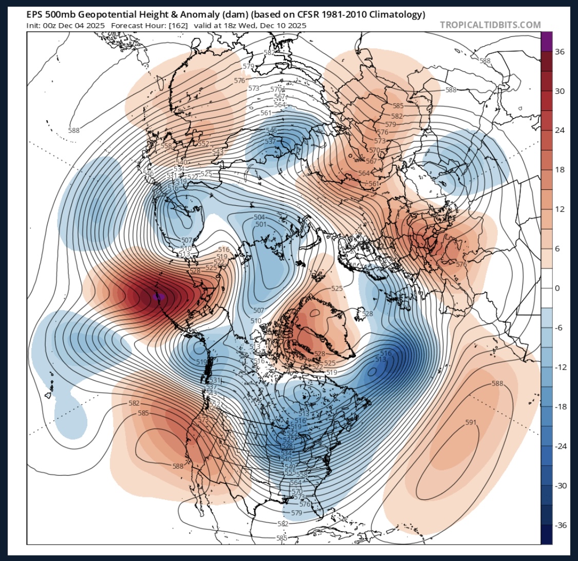
Looking ahead because I’m pissed I’m getting screwed tomorrow. Late next week definitely has some things going for it with a -NAO and 50/50 combo. Also a flat ish +PNA. If we can get that PNA to spike and get the shortwave coming out of the northern stream to dive below us, we could get something going. 0z euro and 6z gfs both develop a weak coastal storm in this window but move it away from us really quick.

-
Still need to watch the 11th-ish.
-
Gfs is drunk Sunday night. Nothing really shows that.
-

2025-2026 Fall/Winter Mountain Thread
Buckethead replied to Buckethead's topic in Southeastern States
Starting the day at 36 in Wolf. Sent from my Pixel 10 Pro using Tapatalk -
6z GFS trying for something Monday and Thursday
-
At least you have a chance, think this one will miss me
-
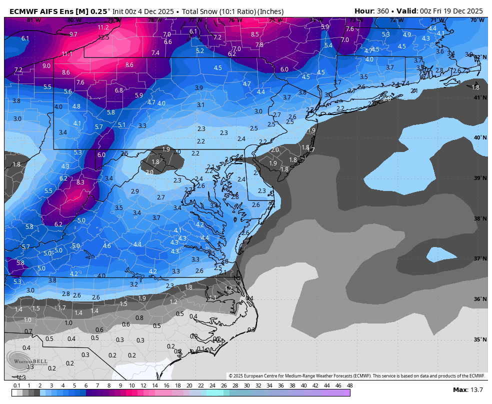
WB 0Z AI EPS.... the NW screw zone remains even on the snowiest model.

-

E PA/NJ/DE Winter 2025-26 Obs/Discussion
Ralph Wiggum replied to LVblizzard's topic in Philadelphia Region
Thats why Ninas blow 95% of the time. You get early cold and chances with shortwaves racing thru the flow, but getting something to produce is a real challenge. Usually dry, suppressed, or sheared out. Then we end up losing the cold (usually) toward the holidays when the storm chances actually increase. Patience won't help us.