All Activity
- Past hour
-
The “dynamic duo” of TS Jerry and the surprise, STS Karen, has added only 1.44 ACE the last 24 hours. Needless to say, they’ll both be back in 2031. The season to date has climbed to only 95.24 with no large amount of ACE yet in site. I’m thinking just under 100 once these 2 storms are history.
-
[[email protected]~]#kill -9 10102025 [[email protected]~]#Cancel Thatsalotofdamage.exe
-
Records: Highs: EWR: 92(1949) NYC: 91 (1939) LGA: 89 (1949) JFK: 86 (1997) Lows: EWR: 35 (1979) NYC: 35 (1888) LGA: 36 (1979) JFK: 35 (1979) Historical: 1780: The Hurricane Season of 1780 was one of the worst in recorded history. The storm which destroyed the Windward Islands from this date through the 12th is the deadliest ever in recorded Atlantic history. It became known simply as the "Great Hurricane of 1780." It is believed that 22,000 people perished in the week long rampage. 9,000 died on the island of Martinique, 5,000 in Eustatius and 4,000 in Barbados. Thousands more died at sea. It was just one of three deadly hurricanes that month. The first week of the month saw a hurricane strike Jamaica, killing 1,000 people. The eastern Gulf of Mexico was hit later that month, and 2,000 were killed. The October storms hampered much of the British and Spanish Navies and aided the colonies in the American Revolution. (Ref. AccWeather Weather History) 1804 - A famous snow hurricane occurred. The unusual coastal storm caused northerly gales from Maine to New Jersey. Heavy snow fell across New England, with three feet reported at the crest of the Green Mountains. A foot of snow was reported in the Berkshires of southern New England, at Goshen CT. (David Ludlum) 1846: The Great Hurricane of 1846 struck Cuba. The pressure over the island dropped to 916 millibars or 27.06 inches of mercury. 92 vessels in the Havana Harbor was sunk, wrecked, dismasted or severely damaged. The storm went on to wreak great havoc at Key West, FL. Fort Taylor, FL was reportedly reduced to ruins. (Ref. AccWeather Weather History) 1894: A hurricane in the Gulf of Mexico came ashore in the Florida panhandle then moved up the east coast over the coastal land regions, passing only about 20 miles southeast of Atlantic City, NJ, where it weakened to a tropical storm. Atlantic City and New York City measured wind gusts to 60 mph. Although a tropical storm as it entered Rhode Island, Block Island measured a wind gust to 100 mph. (Ref. Wilson Wx. History) 1925: Weekend football games were played in deep snow across New England as up to two feet fell in northern Vermont and New Hampshire. (Ref. AccWeather Weather History) 1928 - The temperature at Minneapolis, MN, reached 90 degrees, their latest such reading of record. (The Weather Channel) 1949 A rapidly deepening area of low pressure produced gale to hurricane force winds across much of Minnesota, Iowa, Wisconsin, Nebraska, Michigan, and the Dakotas. Sustained 1-minute winds reached 85 mph at Rochester, MN and 79 mph at La Crosse, WI during the early afternoon. Winds gusts were as high as 100 mph. This produced extensive damage to buildings and power lines. In addition, many corn crops were flattened. Bizzare storm brings Hurricane force winds across Minnesota. This was possibly the strongest non-thunderstorm winds seen in Minnesota. Top winds were clocked at 100 mph at Rochester, with a gust of 89 mph at the Twin Cities International Airport. 4 deaths and 81 injuries were reported. Numerous store windows were broken, and large chimneys toppled. The top 10 floors of the Foshay building were evacuated with the tenants feeling seasick from the swaying building. (Ref. AccWeather Weather History) 1954: Heavy rains continued for a second day across parts of northern Illinois. Up to 5 inches of rain created havoc as traffic was cut off by flooded underpasses and communication and power were seriously affected. Many people had to be evacuated. A small tornado was also reported. Flood damage from the two day event was estimated at $25 million dollars in the Chicago area and at least $10 million dollars in Chicago. (Ref. Wilson Wx. History) 1962: Severe thunderstorms brought very destructive hail to Bryan County, in southeast Oklahoma. Hail up to the size of golf balls broke more than half the windows of the businesses in downtown Durant, shattered many car windshields, broke out 1,400 panes of glass in seven greenhouses, and broke electrical insulators, resulting in widespread power outages. (Ref. Wilson Wx. History) 1972: Chicago, Illinois from the 9th to the 11th: A 48-hour deluge of 6.72 inches (170.7 mm) floods the Chicago River, causing ten million dollars damage in the Chicago area. (Ref. WxDoctor) 1973 - Fifteen to 20 inch rains deluged north central Oklahoma in thirteen hours producing record flooding. Enid was drenched with 15.68 inches of rain from the nearly stationary thunderstorms, which established a state 24 hour rainfall record. Dover OK reported 125 of 150 homes damaged by flooding. (David Ludlum) (The Weather Channel) 1979 - A storm blanketed Worcester, MA, with 7.5 inches of snow, a record snowfall total for so early in the season for that location. (The Weather Channel) 1979: This was the earliest snow ever recorded in Richmond, Virginia. KRIC had but a trace of snow on this date. (Ref. Richmond Weather Records - KRIC) This is also the earliest snow ever recorded at the Annandale-Barcroft Hills station 0.5 inches. KDCA had 0.3 inches on this date and the greatest snowfall in October was 2.2 inches on October 30, 1925. (Ref. Annandale-Barcroft Hills records) (Ref. Washington Weather Records - KDCA)Dale Enterprise west of Harrisonburg had 8.0 the heaviest early snow in more than 143 years records there back to 1868 (The Weather Channel) 1982: Beginning on the 8th through this date, record amounts of snow piled up in the northern Black Hills in South Dakota. Not only was the storm a record breaker because it came so early in the season, it was a record snowfall producer for anytime of year. Amounts of 3 to 6 feet were common across the northern hills. On the 9th, 32 inches of snow buried the town of Lead. The 32 inches that day is the most on record for a 24 hour period in South Dakota. Lead's three day storm total of 55.3 inches is the largest single storm total on record in South Dakota. (Ref. Wilson Wx. History) 1987 - Eleven cities in the north central U.S. reported record low temperatures for the date, including Colorado Springs CO with a reading of 23 degrees, and Havre MT with a low of 11 degrees above zero. Light snow was reported as far south as Kansas. Omaha NE reported their third earliest snow of record. (The National Weather Summary) 1988 - Sunny and mild weather prevailed across the nation for Columbus Day. The afternoon high of 77 degrees at Kalispell MT was the warmest reading of record for so late in the autumn season. Thunderstorms developing along a cold front produced wind gusts to 56 mph at Lorain OH. Snowflakes were observed at Milwaukee WI around Noon, but quickly changed to rain as temperature readings were in the lower 60s. (The National Weather Summary) (Storm Data) 1989 - Thunderstorms produced torrential rains along the northeast coast of Florida. Augustine was deluged with 16.08 inches of rain. The heavy rain caused extensive flooding of homes and businesses, and left some roads under three feet of water. Ten cities from South Carolina to New England reported record low temperatures for the date, including Concord NH with a reading of 23 degrees. Temperatures dipped into the 30s in the Carolinas. (Storm Data) (The National Weather Summary) 2000: In Charlotte, NC, the low Oct. 10, 2000 was 30 degrees. This set a record for the earliest date that the temperature has dropped below freezing in Charlotte. St. Joseph, Missouri set a new record low 4 mornings in a row. (Ref. Additional Temperatures Listed On This Link) 2009: Nome, Alaska: Nome experiences its first ever October (Autumn) thunderstorm with five lightning strikes between 8 and 9 PM ADT.(Ref. WxDoctor) (Ref. Weather Guide Calendar with Phenomenal Weather Events 2012 Accord Pub. 2011, USA) 2011: Eight straight days of 100 percent sunshine in Chicago, IL is simply extraordinary - the longest previous streak in October was 7 days back in 1934. It was the longest streak for any month, except the one-time 10-day record established July 21-30, 1916 when a record 95 percent sunshine was received for that month. (Ref. WGN Chicago Weather Clear -- Very Long Period of Clear Weather)
-

Spooky Season (October Disco Thread)
Typhoon Tip replied to Prismshine Productions's topic in New England
Meh... this is how the hemisphere seasonally sheds its therms, though. I.e, longer nights, ideal radiative transfer into free space. Then, with ensuing diurnal insolation being insufficient to add as much energy as the energy that is lost, there is a net cooling in the ambient space. This principle makes me less objectively willing to call anything fake. I get what that means ... I guess I just don't agree in belittling it. My druthers aside, these "fake cold" nights take their toll. More of them as the sun slopes deeper by day, and the nights get yet longer and longer; the cold battery of the winter hemisphere is gaining charge. More proficiently N than S, of course, until the build up becomes significant. -
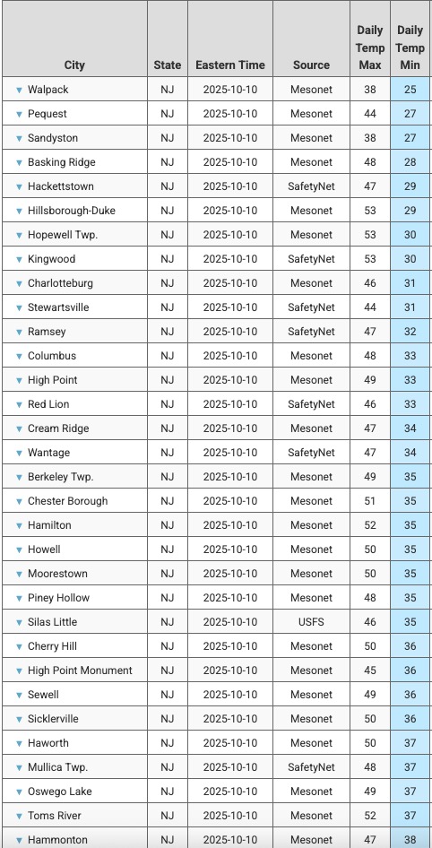
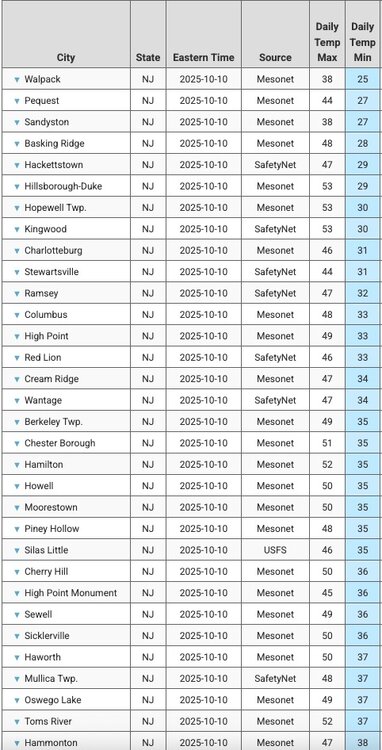
Low here was 37. Just scattered light front at sunrise. Some NJ coldest mins attached:
-
Well, TODAY is the anniversary day! 10/10/79 started my obsession with weather when a 10" snow fell with 80% of the leaves still on the trees. Sounded like people were outside shooting shotguns continuously from all the trees breaking and snapping.
-
(002).thumb.png.6e3d9d46bca5fe41aab7a74871dd8af8.png)
Central PA Fall Discussions and Obs
ChescoWx replied to ChescoWx's topic in Upstate New York/Pennsylvania
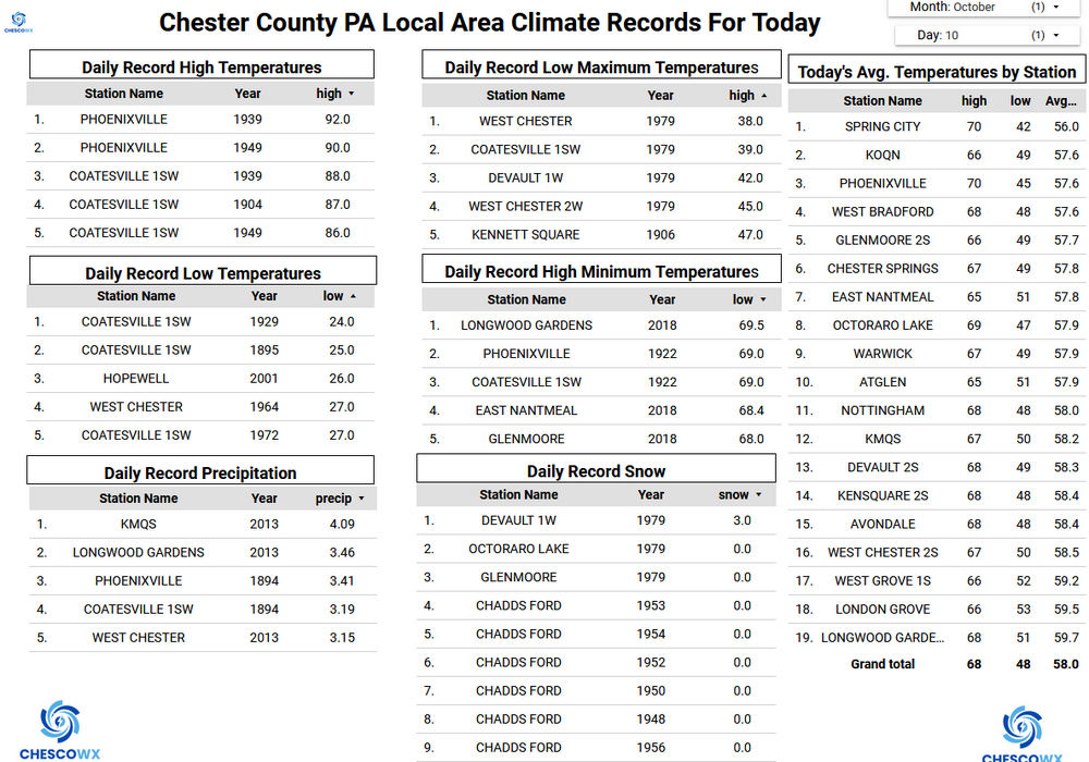
Many spots below 400 feet ASL saw freezing temperatures this morning across Chester and Berks counties. Freezing temperatures were recorded at West Chester, Chester Springs, West Bradford Twp. Devault, Warwick Township and Nottingham. The coldest reading was the 28.9 degrees at Warwick. Here in East Nantmeal at 685 feet ASL we recorded a low of 37.5. This is a record low for this date for this location with records since 2004. Regarding the weekend coastal storm some models have backed off a bit on the westward extent of the heaviest rain across Chester and Berks counties. Rain chances start to increase by tomorrow evening, and showers could continue into Monday.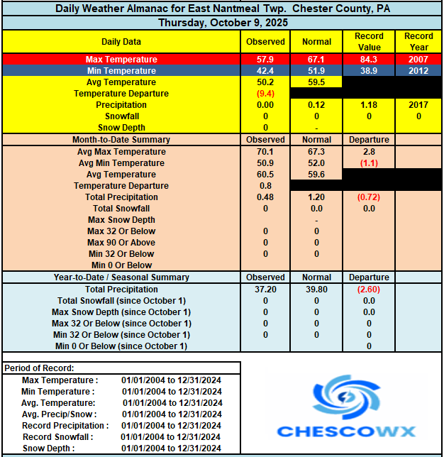
-
 I don't know, think about winter. We most of the time with a coastel we don't know if we are getting 1-3, 3-6 or 4-8 within a few hours before a storm hits. Most of the time it is because of the track Look over all these threads. With rain it is no different, but most the general public won't know the difference between .50" and 1.5" since the forecast said rain and it did rain.
- 105 replies
-
- 1
-

-
- heavy rain
- damaging wind
- (and 2 more)
-

The return of the elusive Nor'easter. Drought buster or bust?
Eskimo Joe replied to dailylurker's topic in Mid Atlantic
tl;dr Congrats New England -
True, but what else do you expect? Even those that you think are good do the same thing if they are trying to make a living. They are a business, just like all the ads you see on TV. It is up to the subscriber to decide whether they think Bam is good or not to hand over their $, just like with everything else we pay for. Eventually if they keep putting out crap, no one will subscribe. It is pretty easy to block them or scroll by. Imagine wasting your time doing what Don did with a post here dissecting their one post (that eventually they did amend). They are laughing at you too for doing that.
-
E PA/NJ/DE Autumn 2025 Obs/Discussion
ChescoWx replied to PhiEaglesfan712's topic in Philadelphia Region
Many spots below 400 feet ASL saw freezing temperatures this morning across Chester and Berks counties. Freezing temperatures were recorded at West Chester, Chester Springs, West Bradford Twp. Devault, Warwick Township and Nottingham. The coldest reading was the 28.9 degrees at Warwick. Here in East Nantmeal at 685 feet ASL we recorded a low of 37.5. This is a record low for this date for this location with records since 2004. Regarding the weekend coastal storm some models have backed off a bit on the westward extent of the heaviest rain across Chester and Berks counties. Rain chances start to increase by tomorrow evening, and showers could continue into Monday.
-

Pittsburgh PA Fall 2025 Thread
TheClimateChanger replied to TheClimateChanger's topic in Upstate New York/Pennsylvania
Definitely had some solid frost each of the last two mornings in my area, especially heavy on the rooftops. Did not drop below freezing though on my thermometer. -

"Potentially" powerful Nor'easter Sun-Mon 10/12-13/25 with needed rain-especially south of I84, and fairly high impact sct coastal gusts 50+ MPH and possibly moderate or greater coastal flooding at the midday Sun and Monday high tide cycles.
Stormlover74 replied to wdrag's topic in New York City Metro
Lately yes but usually 2 days out we have some consensus -
54 / 37 from 36. Fall is in the air. Clouds moving in from the ocean but partly cloudy overall. Clouds look to build in Sat - Tue as he cutoff and coastal meander offshore. Complex storm much discussed in the other thread 1 - 3 inches Between Sunday - Tue nigh, Euro lingers the longest and drops most rain Tue / Wed AM. Clear out and dries out Wed and through the end of the week and next weekend. Ridging comes northeast but overall near normal beyond.
-
It was early here based on 21 seasons of records. The average dates are 10/12 for first frost, 10/22 for first freeze and 10/28 for first hard freeze.
-
I wonder how cold it got in November 1950? I know there were a lot of single digit and subzero readings in Ohio during the great blizzard which dropped a widespread 20-30+ inches of snow in the Ohio Valley and Appalachians.
-
imo the -QBO is slightly worse for us since we'll get more southeast ridging in general(since convection will be more centered around the equator, more poleward convection would also push the pattern more poleward), however, it also means more active/stronger MJO, as well as a weaker PV earlier on, so that could help overwhelm any other subseasonal factor in providing good patterns even if brief if MJO propagates to favorable phases(which, so far, it looks decently good to do so) probably a decent amount better for new england/interior northeast since they are a lot less sensitive to SER, and a lot was very suppressed for them for a good chunk of the winter
-
I canceled that whole thought process after the overnight runs . More boredom ahead as far as eye can see.
-

Spooky Season (October Disco Thread)
dendrite replied to Prismshine Productions's topic in New England
Mins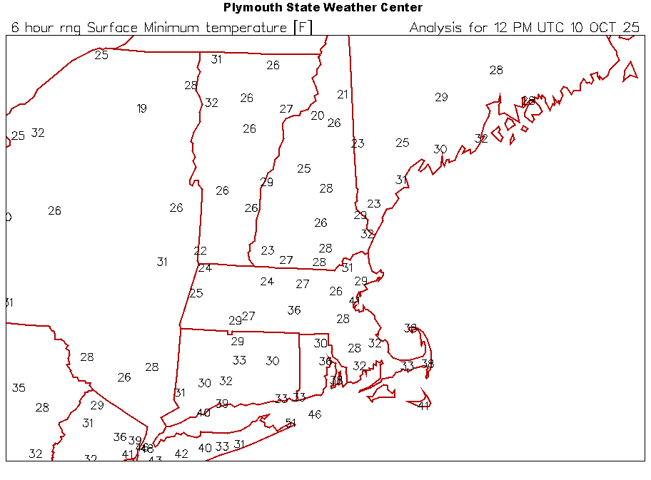
-
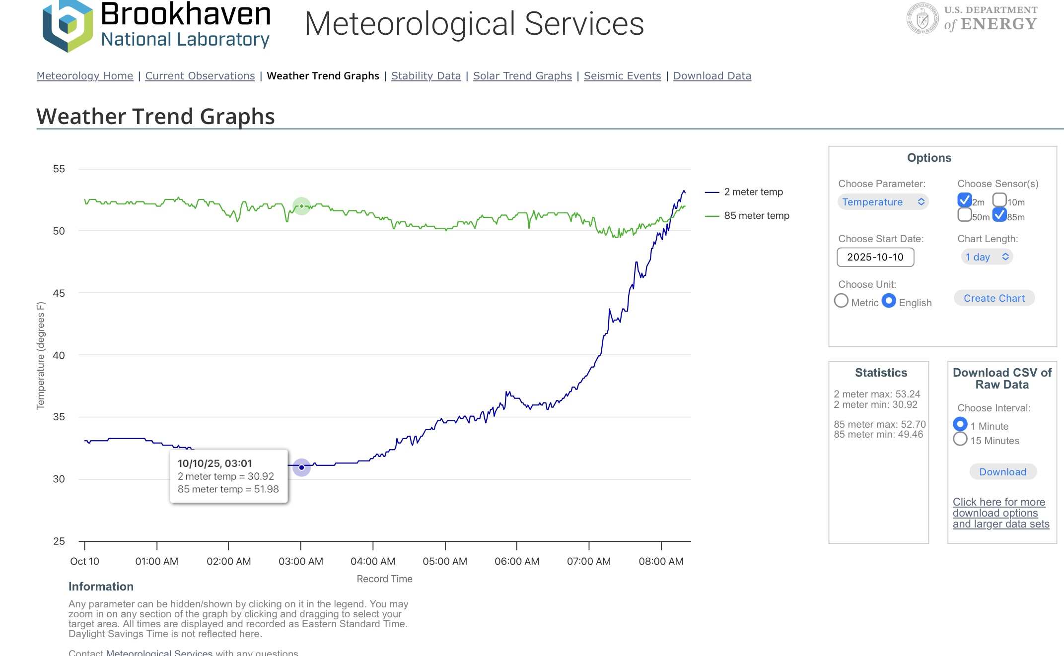
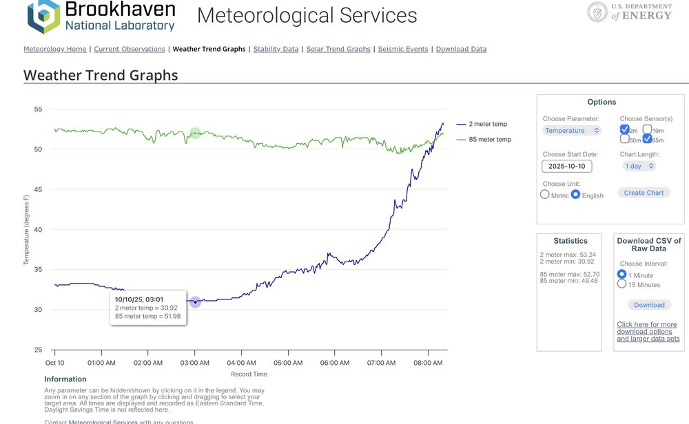
Close to a 20° difference between 2m and 85m further to your east this morning.
-
43 this morning
-

The return of the elusive Nor'easter. Drought buster or bust?
MillvilleWx replied to dailylurker's topic in Mid Atlantic
Yup. We were discussing this overnight as well about the handling of 5H. My hunch is we’ll be sneaking closer to the ECMWF solutions where it’ll rain but could very well support a minima from northeast NC up to the Lower Shore before picking back up closer to 40N. Sounds familiar, right? -
Union won the supporters’ shield at least. I was at the game Saturday night when they clinched it and the place was electric.
-
I really don't remember many coastal storms the past decade+ that held a track for days, balloons or not. The models do this song and dance pretty much every single time. It is not a new thing.
-
Something else that’s often lost on these hybrids is that the magnitude of impacts are often dictated by the strength of the surface high; not the min SLP. The surface high has been very gradually strengthening with time on guidance.