All Activity
- Past hour
-
Record breaking heat in a super Nino... we're so cooked
-
 jpnd81 joined the community
 -
Radar looks clear. Seabreeze front very prominent on radar and is splitting Long Island almost exactly in half running east to west.
-
Actually .. not disputing this at all but I did notice the EPS sending signals for back when it was over 300 hours. I post about it around June 11th or so... I'll try to find it
-

2026-2027 Super El Nino
Dillsburg Keith replied to Stormchaserchuck1's topic in Weather Forecasting and Discussion
There was a blizzard in Jan 2016..historic for many, so they were partly right -
 Weather Badger joined the community
 -
 Uncle Gust joined the community
 -
Stop with the political stuff. Please and thank you.
-
 jim.ione27 joined the community
 -
Pulled into work and winds are blowing. Kinda makes the heat slightly tolerable. But I am watching what looks like a storm try to build to my southeast, probably south of Brooklyn and moving west/southwestish. How are we supposed to attach/add pics if the allowable size of 10kb it's reached 30 years ago? Lol jc
-
90/75 My sweat glands have activated. Quite a bit more cloud cover than I expected today.
-
90/80 imby is tough, air is just so thick. station might be running a bit warm/moist, but another PWS a couple blocks away is showing 93/81.
-
(002).thumb.png.6e3d9d46bca5fe41aab7a74871dd8af8.png) With a chance that some locations could see a 100-degree day later this week I went back and analyzed 30 temperature stations across the area to see just how rare such a day has become. A 100-degree day is a rare occurrence across most spots across the County. With the potential being even more rare across the relatively higher ridge stations above 595 ft. In fact the last time any ridge location station saw a 100-degree reading was 15 years ago back on July 22, 2011. Of the 18 current stations across the area that report temperatures 9 of these have never recorded such a day. Our lowest elevation stations at Phoenixville and nearby Spring City both recorded a 100+ day last June. To illustrate how different the temperature elevation impact can be on June 26, 2025 while Spring City (256 ft ASL) was hitting the century mark....not too far away at Glenmoore DEOS (620 FT ASL) but 400 feet higher the high was 10 degrees cooler at "only" 90.6
With a chance that some locations could see a 100-degree day later this week I went back and analyzed 30 temperature stations across the area to see just how rare such a day has become. A 100-degree day is a rare occurrence across most spots across the County. With the potential being even more rare across the relatively higher ridge stations above 595 ft. In fact the last time any ridge location station saw a 100-degree reading was 15 years ago back on July 22, 2011. Of the 18 current stations across the area that report temperatures 9 of these have never recorded such a day. Our lowest elevation stations at Phoenixville and nearby Spring City both recorded a 100+ day last June. To illustrate how different the temperature elevation impact can be on June 26, 2025 while Spring City (256 ft ASL) was hitting the century mark....not too far away at Glenmoore DEOS (620 FT ASL) but 400 feet higher the high was 10 degrees cooler at "only" 90.6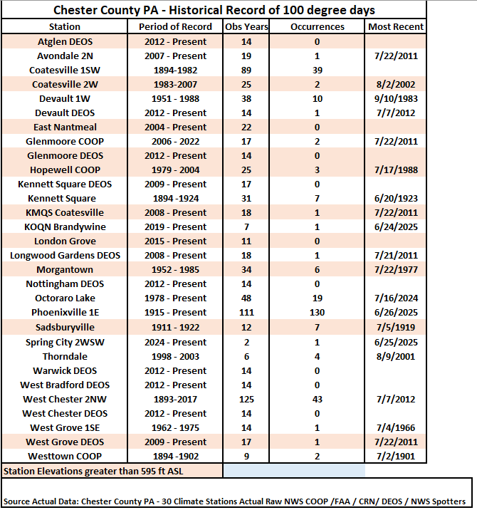
-

E PA/NJ/DE Summer 2026 Obs/Discussion
Mikeymac5306 replied to PhiEaglesfan712's topic in Philadelphia Region
Got an email from the guys doing the 250th parade Friday in Philly. They are cutting the route down to one mile rather than the 2.4 miles it was planned for. They are adding extra water stations and have SEPTA buses on standby for cooling areas. -
LOL, I was building a case! AI makes it easy in today's world. I should tell you sometime about all the acrobatics I went thru during the late 60's to construct a temperature measuring shelter to NWS standards!!
-
 geographermom joined the community
 -
Maybe. My older brother was in the Corps of Engineers and during the monsoon season of his Vietnam year (1967 into 68) there would be thunder and torrential rain 3-5 PM, so regular that one could almost set one's watch by the storm times.
-
 Deborahe347 joined the community
 -
The new (12Z) UKMET has nothing from the lemon designated as a weak TD, unlike the prior 3 full runs. However, Pivotal’s UK maps still have just about the same as a weak TD (a closed weak sfc low) along a similar track. It approaches SC late on 7/2 and comes into SC with hardly any circ. but with strong and persistent convection for S SC on 7/3-4 with a max of a whopping 9” 35 miles W of CHS before the convection heads NE up the Carolinas’ coast 7/5-6. That very heavy precip though is a major outlier vs other models and thus is highly unlikely as of now.
-
Also not sure if it was talked about but the GFS was all over this mid to late week heat wave while the EURO had no interest in it. Another impressive mid to long range win for the GFS.
-
 James White joined the community
 -
I more have a problem with this paragraph. “The US will endure one of its most expansive heatwaves in history this week. Then another long lasting record breaking heat dome will plague #Europe again, back to back on its worst #heatwave in its history!” Every anomalous outbreak doesn’t have to be dubbed “worst in history” . As you stated earlier there have been higher temperatures recorded much more humid air masses and more dangerous/long lasting heat waves. Let’s see where this one ranks when all is said and done. Now if we actually hit 100-104 over a large number of climo sites plus humidity that’s a different ball game. However it seems like we do 95-99 for a week stretch every year.
-
Outside after a scattered t-storm is brutal. Sure the temperature is lower, but with all the evaporation from that storm and the lower temp, the air is much closer to saturation. It is the worst sticky soupy feeling. Much prefer the low RH with the triple digit heat that comes before.
-
 rsigns joined the community
 -

Junorch obs and discussion 2026
CT Valley Snowman replied to Damage In Tolland's topic in New England
Deep, deep summer week. Big heat, big dews, hopefully big storms. -
The new (12Z) UKMET has nothing designated as a weak TD, unlike the prior 3 full runs. However, Pivotal’s UK maps still have just about the same as a weak TD (a closed weak sfc low) along a similar track. It approaches SC late on 7/2 and comes into SC with hardly any circ. but with strong and persistent convection for S SC on 7/3-4 with a max of a whopping 9” 35 miles W of CHS before the convection heads NE up the Carolinas’ coast 7/5-6. That very heavy precip though is a major outlier vs other models and thus is highly unlikely as of now.
-
81/48 Gah it’s so nice outside. Drinking in these dews before the swamp arrives.
-
i was being facetious lol. I do remember somewhat frequent brownouts due to heat in the mid-late 1990s.
-
My west facing analog therm has hit 100+ several times already this year :-)
- Today
-
I'm going by the Staunton official records. A thermometer exposed to the rays of the sun or other artificial heating can register significantly higher than actual air temperature. Even reflective heat can artificially inflate the temperature.
-
Fireworks Heat Contest W 7/1 - S 7/4 for Five MA Airports
Roger Ramjet replied to nw baltimore wx's topic in Mid Atlantic
DCA: 96, 101, 102, 100 BWI: 97, 102, 101, 99 IAD: 96, 102, 101, 100 SBY: 95, 100, 100, 99 RIC: 98, 103, 102, 101 Total Rain: 0.00 -
Damn! If that’s true, that’s kinda bananas. Was going to Gilgo and wanted to see about any possible rip currents during the morning and the site was down. And then when I saw the heat models being posted in this thread for this week, when we got back, went to NWS and saw it was still down.
-
Models are always bad in mesoscale season, as you know. At least this website is back to normal speed. Saturday had Crossville special written all over it. I gave up mid-afternoon after cells near Pikeville looked like crap. Then at sunset while I'm back home enjoying the World Cup, tornado warning Cumberland Co. What a hobby!


.thumb.jpg.ad3a2e31d30aff035044689b311a0540.jpg)


