All Activity
- Today
-
 snoopn4pnuts joined the community
 -
The issue gets worse and worse. Wait until the first heatwave and it’s 92+ at every station but 89 at the Park and the media reports 89. It’s a big pet peeve of mine because it’s not the reality of the experience of the everyday person.
-
Man I love it so much when pro forecasters talk dirty like this: https://forecast.weather.gov/product.php?site=LWX&issuedby=LWX&product=AFD&format=CI&version=1&glossary=1&highlight=off .LONG TERM /WEDNESDAY THROUGH SUNDAY/... The upper low that will impact the region over the next few days will start to shear out into an open wave as it lifts northeastward from the Mid-Atlantic on Wednesday toward the Northeastern states by Thursday. As this occurs, we should start to see a few more breaks in the cloud cover, and as a result, should heat a little better during the day. High temperatures are expected to reach into the 70s on Wednesday, and then upper 70s to lower 80s on Thursday. Showers and thunderstorms appear possible either afternoon, with the highest coverage expected Wednesday afternoon beneath the upper low. Model soundings show mostly saturated profiles, along with some limited instability (around 500-1500 J/kg) and relatively weak flow through the depth of the troposphere. As a result, slow moving, heavy rain producing thunderstorms appear possible. While there likely won`t be any synoptic scale boundaries to focus regeneration of storms in any one given location, the slow storm motions and heavy rainfall rates may be enough to cause localized instances of flooding on the heels of heavy rains on Monday and Tuesday. Areal coverage of storms should be a bit lower, and storm motions should be a bit faster on Thursday. When coupled with slightly drier vertical profiles, this should lead to a lesser threat for flooding on Thursday. As we move toward the end of the week, a deep upper low and attendant strong surface low will slowly track eastward into the Upper Great Lakes. As this occurs, rich low-level moisture will be drawn north and east from the Gulf into the Ohio Valley and Mid- Atlantic. Simultaneously, a strong belt of mid-level flow (35-50 knots in the 700-500 hPa layer) will spread overtop that rich low- level moisture, advecting a remnant elevated mixed layer plume eastward as it does so. Rich low-level moisture, steeper than climatology mid-level lapse rates, and strong mid-level flow will result in an environment on Friday, and potentially even Saturday as well, characterized by both strong instability and strong deep layer shear. The EPS and GEPS ensemble means have 2000-3000 J/kg CAPE along with 35-50 knots of 0-6 km bulk shear. The GEFS show lesser instability and similar shear values, but have a well-know low bias when it comes to instability. This type of parameter space raises concerns for severe thunderstorms. While the parameter space being advertised at the moment by models is toward the higher end of what we typically see in this part of the country, we`re still at day 6 and 7, and there is plenty of time for things to change, especially when an upper level low is involved (which models notoriously struggle with in the long range). With an elevated mixed layer involved, there are also signs of stronger capping than we typically see, so that could complicate things as well. For now, the end of the week is a period to monitor for potential severe thunderstorms, with the expectation that forecast can and will change this far out.
-
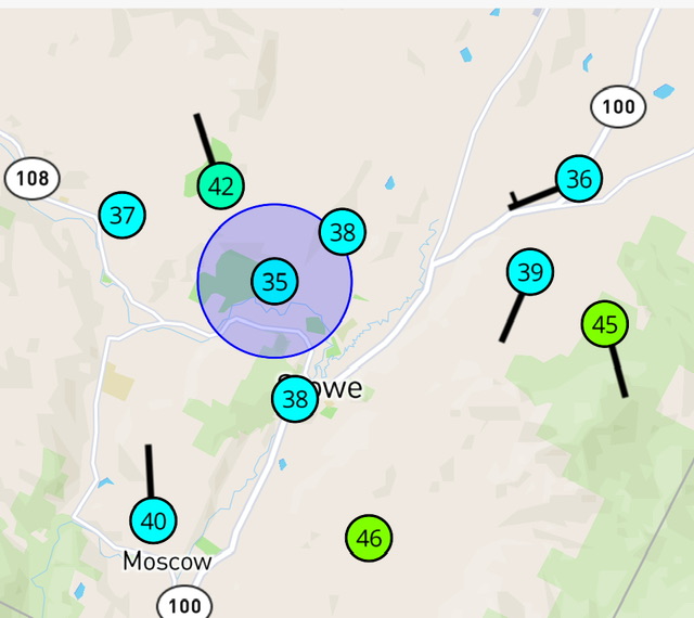
37.4°/32.1° here at 1250’. We’ll see if we frost out.
-
Look guys I know this has nothing to do with this discussion, and I really hope you all over there get a lot of beneficial rain while staying safe, especially in the orographic portion of the sub. I need to know what kind of ENSO state we had in 2011, especially if it was negative-neutral, like we are having now. Thanks. Enjoy all the cool rain!!!
-
Yeah, the CAMs this evening look more like the earlier globals with decent rains from the Bay to all points west. Still not as good of a consistent signal for the Eastern Shore, but it does seem like even those areas should eventually do at least ok (later Tuesday into Wednesday??).
-
Fri/Sat is definitely worth watching, but there is a lot of disagreement on whether we get decent height falls or if they're focused more north of here. Any modest height falls would probably bring a severe threat, given the good moisture in place and good wind fields.
- 487 replies
-
- 1
-

-
- severe
- thunderstorms
- (and 2 more)
-
36F at MVL. 35F at the station on the edge of the Stowe Country Club. That's the closest to me. River bottom and open field topography. As soon as you go a 100-200ft up it warms real fast. Very fake but refreshing. No match for SLK’s 30/27 right now.
-
43.7/36 Probably safe here, but the high crests over us before sunrise…still a 2-3mph wind for now.
-
Pretty decent start by Eflin in his return. Maybe the Os can get a little something good going for a change. They are due.
-
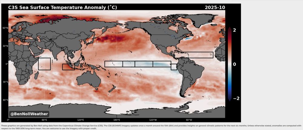
Be interesting how the ENSO plays out into severe fall.I know some of the NMME'S has been showing a resurgent Nina.But by BN's maps and some of the NMME'S i'd think the GOM could get rather active from June -Aug,thats JMHO. https://www.bennollweather.com/climate-graphics
-
Temp has already dropped 21 degrees off the high today. 58 to 37. And dropping...
-
-
Crazy to see 96° at International Falls, MN today. The icebox of the nation. Detroit has never officially hit 96° in May! Very pleasant Mother's Day here. Lows in the mid 40s, highs mid 60s and going back to the 40s tonight.
-
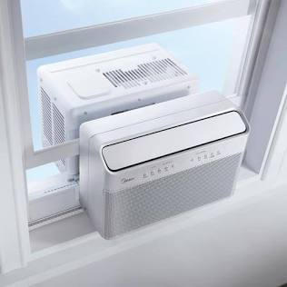
I can’t recommend the Midea u-shaped AC high enough. Quiet and efficient. I’ve had one for 2 years and I love it.
-
Even excluding today's 99F, the mean high temperature at Grand Forks was running as 8th warmest on record for the first 10 days of the month. This is an interesting set of analog years. Not sure it means much, but 1934, 1936 & 1988. Even 1980 & 1977 had some big heat. The two most recent years on the list don't follow, however - especially 2023.
-
Saw tons of them latching on to muddy puddles and shallow pools during my walk in the woods earlier. I think in less than a week it’s gonna get pretty rough with new waves of the little vampires fanning out in every possible direction.
-

Spring 2025 Medium/Long Range Discussion
Chicago Storm replied to Chicago Storm's topic in Lakes/Ohio Valley
might get 49’d on the 22nd. -
Felt like a late summer day with the high sun angle and of course, the increasingly long daylight. The breeze did make it feel a little nippy at times but after the recent deluge, I can’t complain at all. Can’t believe how dry the air is too, almost desert like with this airmass over us. We take and bake!
-
Stalled out after the 12:53 pm CDT observation, which is really before local solar noon during daylight saving time. Thought they would climb to at least 101 or 102, after rising 39F already by that point of the day. There were monthly record highs at several locations, including International Falls, which reached 96F, beating out the record of 95F from May 21, 1964. Minot, ND reached 99, matching the value reached on May 22, 1980 at the airport. While not a ThreadEx location, it does look like the NWS does an unofficial thread supplying records prior to 1948 from the Experimental Station where there were a couple of higher values (100 on May 23, 1928 & 105 on May 31, 1934). Could see some monthly record high minimums tomorrow at several locations as forecast lows for tonight are close to the highest observed in the month of May, including International Falls where the forecast low of 66F would tie the monthly record high.
-
Bust on high temps today? I thought we were supposed to be around 75 as of last night's forecast? On another note, it seems Central Park is going to be totally irrelevant for the foreseeable future.
-

Spring 2025 Medium/Long Range Discussion
Spartman replied to Chicago Storm's topic in Lakes/Ohio Valley
Not fine according to 18z GFS. Thursday May 22 (some spots stuck in the mid to upper 40s): The day before Memorial Day (stuck in the low to mid 50s): -
I need to pick up some window air conditioners this season. Unhappy with a GE unit I purchased last year. What brands/models are folks having success with that last more than two or three seasons? As much as I like to do things to help the environment, these high efficiency window units don't last like the units from the "good ole days". And before you ask - can't afford mini-splits... yet...
-
It's May! Can't stand to post warm season related questions in the winter banter thread!
-
Low of 61, cloudy high of 74. Picked up .17" in the bucket this morning.
-
Highs: ACY: 85 PHL: 82 BLM: 81 EWR: 81 New Brnswck: 80 JFK: 80* (no intra hour highs registered) TTN: 79 TEB: 79 LGA: 79 ISP: 78 NYC: 77