All Activity
- Past hour
-
My guess is no, as their lowest is 21.4" in 1954-55. However, 1997-98 is missing and might've been a candidate for lowest.
-

Augdewst 2026: Summer's Last Stand
jlauderdal replied to Prismshine Productions's topic in New England
Raining and 72 at my location -

2026 Mid-Atlantic Severe Storm General Discussion
George BM replied to Kmlwx's topic in Mid Atlantic
https://schumacher.atmos.colostate.edu/hilla/csu_mlp/csu_severe.php -
glad we don’t live there, nor do we live in the NYC forum
-
This has about a 1% verification probability, especially southwestern portions
-

Spring/Summer 2026 Pattern Discussion Thread
jaxjagman replied to Carvers Gap's topic in Tennessee Valley
Freaking hot. I went back and looked at August in the strong NINOS at thermals in the MID state,mainly 82-97,i still discount 2015,it just wasn't the same type NINO IN 1982 we averaged between 88-90f,we only had 3 consective days reaching 90F+ IN 1997 we hit 93F on 4th,16=17th.But the avg tempa in whole was 86.6 for the month I blame this on the PDO myself ot it should be a good starting point at least.Its what makes this NINO unique,but it better change the next several weeks,its rare to see such a negative PDO than positive this time of year in a stromg NINO Id be kinda concerned about the PDO right now into winter,it better start going to negative real soon,you got to remember in NINOS your indices go south into fall and winter,they dont go north -

Spring/Summer 2026 Pattern Discussion Thread
nrgjeff replied to Carvers Gap's topic in Tennessee Valley
Frankly I'd rather talk eclipses instead of hot weather, lol! Yeah the lunar eclipse Aug. 27-28 is happening Time and Date dot com also has good info. Perhaps unpopular take, but I believe lunar eclipses are very under-rated. I'm not gonna sit here and say they compete with total solar or bright Aurora; they don't. But I'm gonna say a deep / total lunar eclipse competes with comets and other astro-treats. I prefer a lunar eclipse over structure only storm chase, perhaps even over brief tornado. Then while with solar, it's 100% total or nothing! ..Lunar is different. Deep partial with long diamond ring phase is really gorgeous. With solar the diamond can't compete with Totality. Lunar is different.. I love a 95-98% partial. Had that back in 2022 and it was stunning. Finally, clouds are more forgiving. We got about an hour vs 2-4 precious minutes. From @KakashiHatake2000 above originally Met Eric Snitil.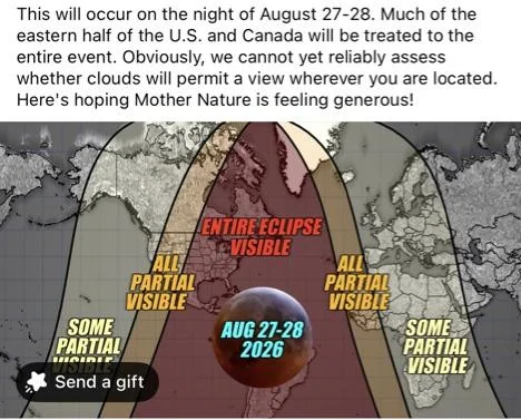
-
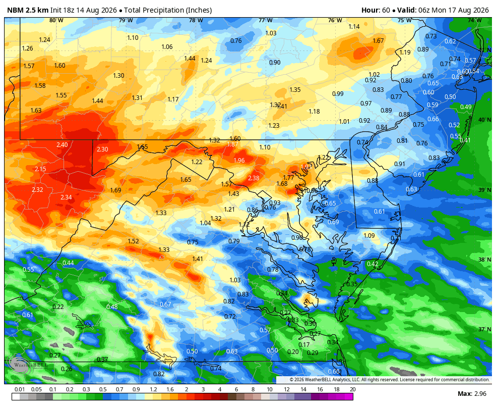
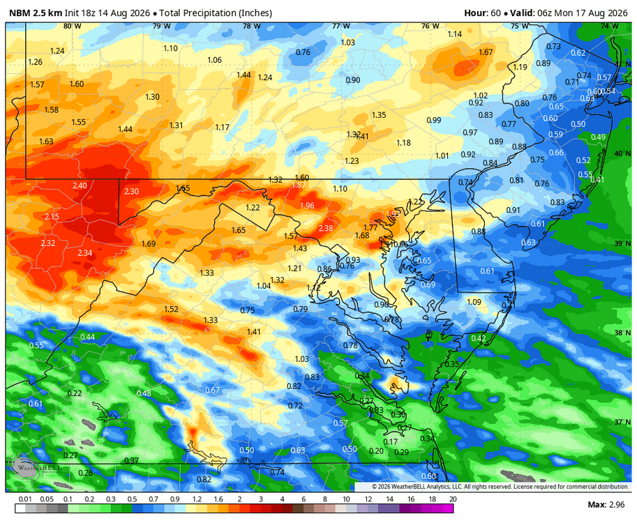
WB 18Z NBM thru Sunday.
-
Man it’s sweltering. Right now it’s 102 at 49% humidity for a feels like temp of 120
-
Tuesday was insane here around cmh. Definitely most severe I've seen since the 2012 derecho. Also, there had to have been some imbedded weak tornados in the midst of everything because I find it hard to believe that straight line winds can flip cars on a highway, (it's not like they were high profile or trucks). I've also seen a lot of tree damage around the burbs where there were grouping of large trees that were completely snapped at the trunk and the bark looked like it was twisted off. Either way, what a day. Finally got business back on line. Tomorrow we might have another round but hopefully by me posting this I just jinxed it away.
-
Can you provide a link to the CSU MLP?
-

Spring/Summer 2026 Pattern Discussion Thread
John1122 replied to Carvers Gap's topic in Tennessee Valley
It's something to see, how heavy the rain is when it hits. Absolutely torrential. The sheer amount of thunder this summer is crazy. -
 buy Viagra online: MenCare - Cheap Viagra 100mg
 - Today
-
The bottom has dropped out here in Waynesville. Lot's of street flooding.
-
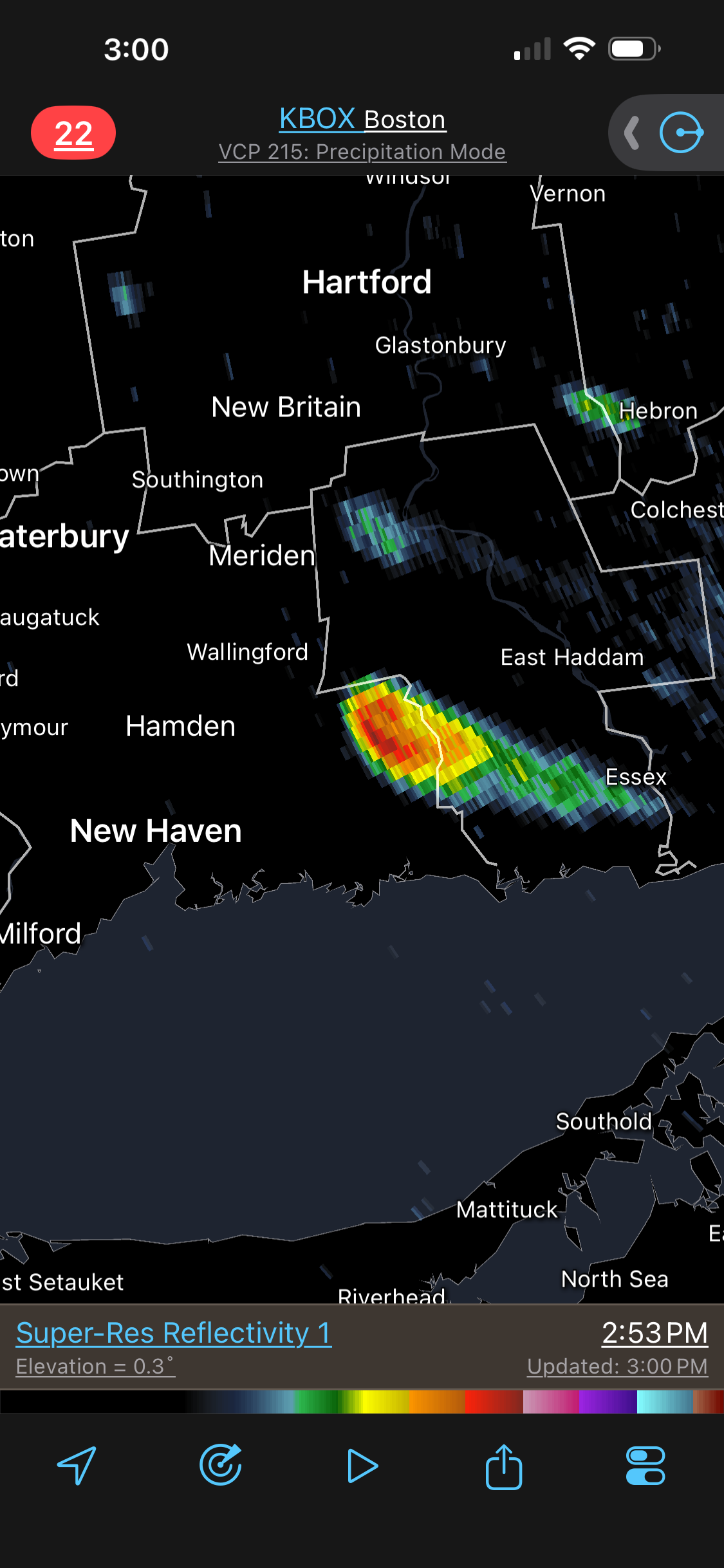
DIT with some hail to his north again.
-

Augdewst 2026: Summer's Last Stand
vortex95 replied to Prismshine Productions's topic in New England
The HVN area just can't be left alone!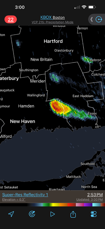
-

Central PA Summer 2026 Discussion/Obs Thread
Voyager replied to Voyager's topic in Upstate New York/Pennsylvania
Oh, good luck my friend. I had that done back in 2020, and I hope I never have to do it again. I was out of work for six months after that surgery for recovery and physical therapy, but that was because of the physical nature of my work. You may be able to return to work faster. One thing to be prepared for is pain. It was the most painful therapy I've ever gone through. One word of advice my surgeon gave me was to stay ahead of the pain. Don't try to man up. If he/she doesn't give you a time estimate of when the nerve block will wear off, ask. That nerve block is awesome, but when it wears off, you'll know it. When I came home after surgery, I was like "that wasn't so bad". Yeah right...lol You'll want to take your first Vicodin, Percocet, or whatever they give you an hour before, because if you try to play catch up, you won't. -
I mean, the longer we go without one, the more due we become. Unless we’re considering the possibility that it’ll never happen again, which would be pretty absurd. Also, this period without a SECS isn’t just long for our lifetimes. It’s one for history. BWI has blown past the longest streak of below average snowfall winters since data started being collected. With that being the case, I’d venture to assume this is the longest the Baltimore area has went without a SECS in history, probably by a good margin. That’s why I say, this is not just some bummer of a stretch. This is historically lousy.
-
Guidance is pretty juicy for Sunday.
-
Oppressive out there. Currently 96/82 for a feels like of 121.
-

Central PA Summer 2026 Discussion/Obs Thread
WmsptWx replied to Voyager's topic in Upstate New York/Pennsylvania
Sir, this is the American Weather Forum... -
https://mencarevirtual.com/# Viagra generic over the counter
-
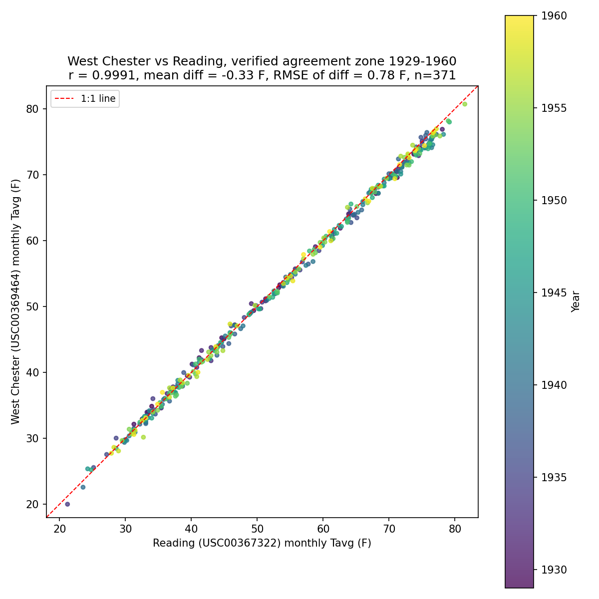
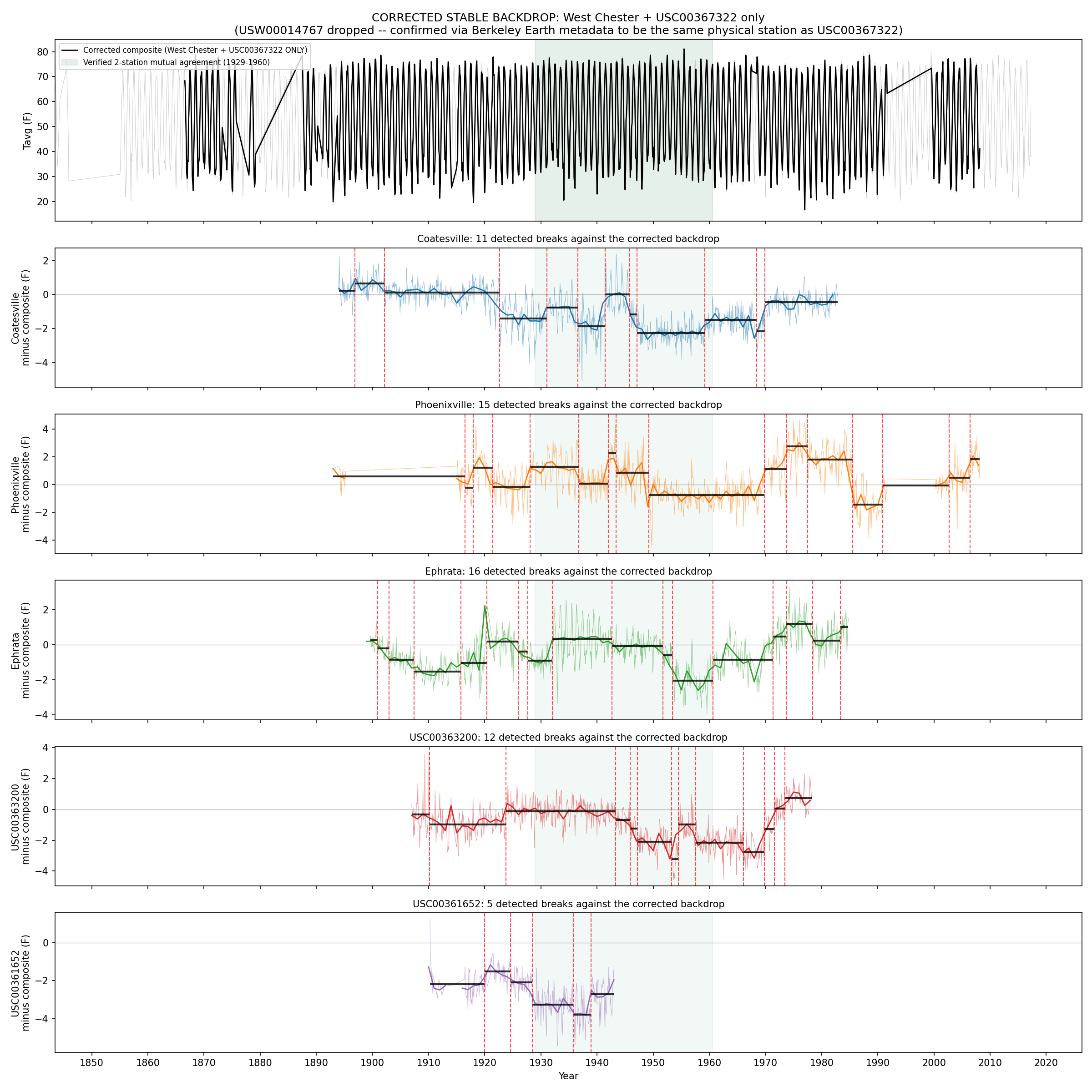
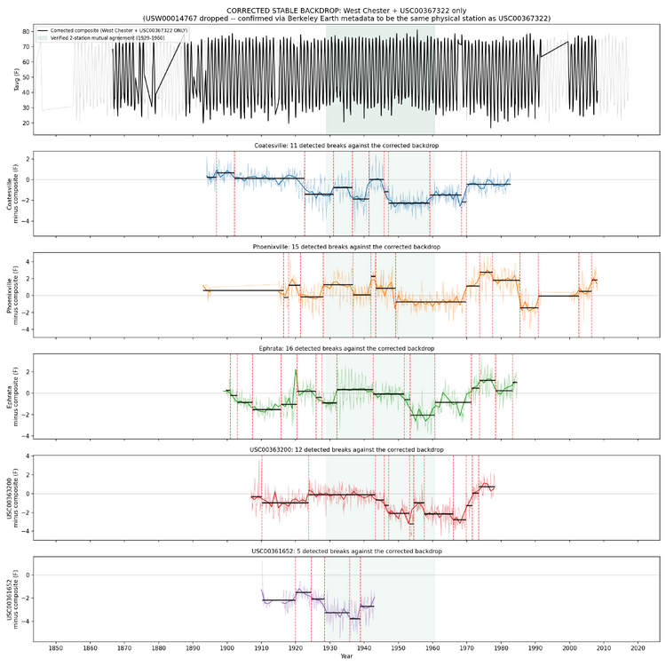
 Chubbs, I did try to expand your manual breakpoint detection process by asking AI to look at surrounding stations and identify "islands" where multiple stations are moving together. I explored various settings, such as the minimum amount of synchronized temperatures before declaring an island, minimum stations to make an island, rules for stations leaving an island and new stations joining, and new islands forming. The geographical area grew too large, pulling in Allentown etc. It will work, but its not a clear demonstration of using semi-local stations to identify breaks. However, Reading and West Chester do synchronize from 1929 to 1960 and make what looks like a solid reference against which breaks can be detected. I have not looked at the individual breaks, but these breaks should be those that would be found by your approach. Edit: this does not rule out the case where Reading and West Chester have overlapping breaks.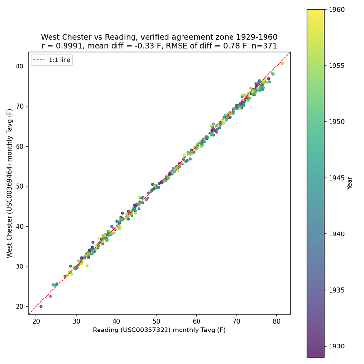
-
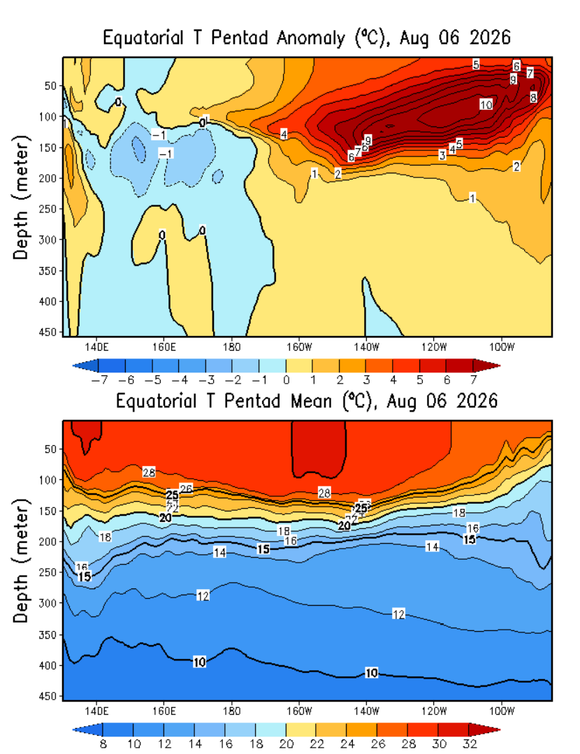
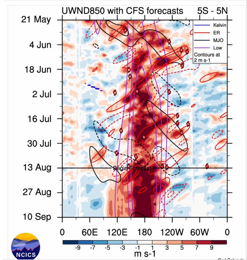
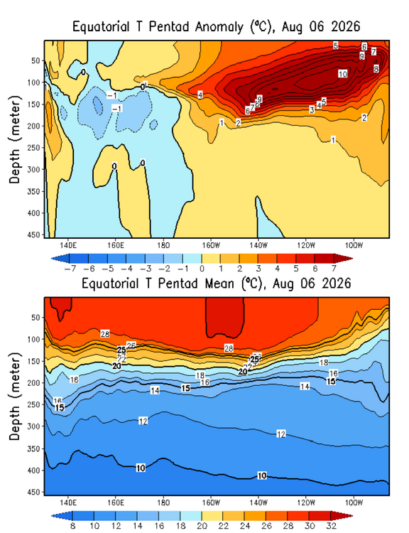
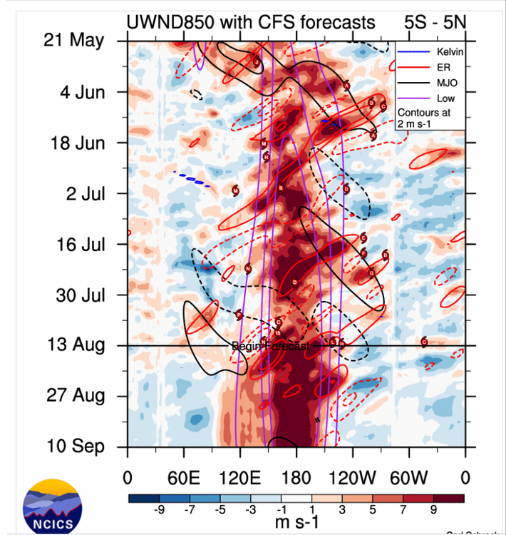
Fairly decent WWB is kicking off,could possible last into Sept.Subsurface has been expanding where the +10C is at,hard to believe this wont hit +11C from DWKW.
-
The 2 historically closest analogs for 26-27 are 97 - 98 and 15 - 16 at approx +2.2. They were both wet but snowfall was wild!! 97 - 98 was a western highlands snow delight with nearly 40 inches at Staunton/Blacksburg. Huge disappointment at Winchester and D.C. with less than 1 inch. 15 - 16 found 26 inches at my place, Winchester 32 and D.C. 22. More than +2.0 is highly favored to be wet but correct AO and NAO blocking is important to get cold air into the mix. We just can't know at this time. We should know by March 15.