All Activity
- Past hour
-

“Cory’s in LA! Let’s MECS!” Jan. 24-26 Disco
powderfreak replied to TheSnowman's topic in New England
I'd lower that by 30% to be honest. Even a widespread 8-12" would be a noteworthy event. -

January 2026 regional war/obs/disco thread
Torch Tiger replied to Baroclinic Zone's topic in New England
she gone -

“Cory’s in LA! Let’s MECS!” Jan. 24-26 Disco
weathafella replied to TheSnowman's topic in New England
18+ for many. And it seems that in general Monday is back in business on most guidance. -

Jan 24-26 Weekend Snow and Sleetfest Model Thread Part Tres
wxdude64 replied to H2O's topic in Mid Atlantic
Coalin' -

January 25-26 Winter Storm Potential
zenmsav6810 replied to Ralph Wiggum's topic in Philadelphia Region
thats never going to verify. -

Jan 24-26 Weekend Snow and Sleetfest Model Thread Part Tres
jayyy replied to H2O's topic in Mid Atlantic
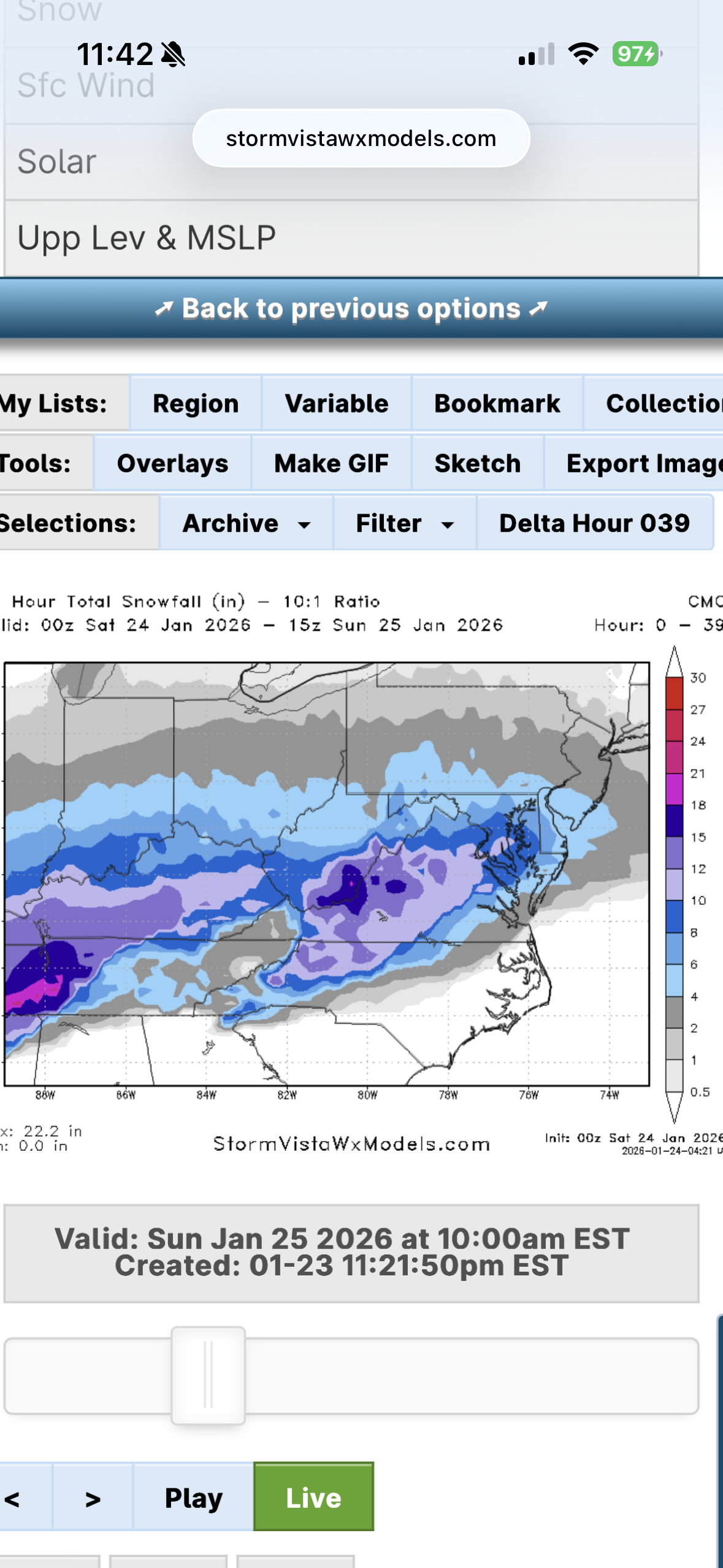
Not up on pivotal just 10:1 -

January 2026 regional war/obs/disco thread
DavisStraight replied to Baroclinic Zone's topic in New England
If he had 16.5 inches he'd be pissed. -
At this point, we should just close the other thread and have this be the main thread.
-
“Cory’s in LA! Let’s MECS!” Jan. 24-26 Disco
weathafella replied to TheSnowman's topic in New England
UGW!! -
Shit... if JEBMAN HIMSELF created the observation thread, I think we're going observe some busted forecasts (we'll get more than expected)!
-

Possible Record Breaking Cold + Snow Sunday 1/25 - Tuesday 1/27
Nibor replied to TriPol's topic in New York City Metro
-

January 24-26: Miracle or Mirage JV/Banter Thread!
nj2va replied to SnowenOutThere's topic in Mid Atlantic
Heyyooo! Ovi ENG and a Caps win! -

January 24-26: Miracle or Mirage JV/Banter Thread!
caviman2201 replied to SnowenOutThere's topic in Mid Atlantic
There we go! Caps sealed it! DAMN they needed that -

January 24-26: Miracle or Mirage JV/Banter Thread!
pazzo83 replied to SnowenOutThere's topic in Mid Atlantic
well well well -

Jan 24-26 Weekend Snow and Sleetfest Model Thread Part Tres
balltermen replied to H2O's topic in Mid Atlantic
This is 10:1 Canadian through 15z sunday
-

January 25-26 Winter Storm Potential
Albedoman replied to Ralph Wiggum's topic in Philadelphia Region
It follows S Mtn folks. Everything Southeast of hereford on rt 29 into east greenville will be the sleet line. Seen this so many many fricking times -

Pittsburgh/Western PA WINTER ‘25/‘26
MikeB_01 replied to Burghblizz's topic in Upstate New York/Pennsylvania
. -

Central PA Winter 25/26 Discussion and Obs
canderson replied to MAG5035's topic in Upstate New York/Pennsylvania
This is the opposite of the Office Pam “these are the same images” meme -
It is cold! And WINDY!
-

Pittsburgh/Western PA WINTER ‘25/‘26
Rd9108 replied to Burghblizz's topic in Upstate New York/Pennsylvania
Gets really warm but the qpf is insane. -
Jan 24-26 Weekend Snow and Sleetfest Model Thread Part Tres
nj2va replied to H2O's topic in Mid Atlantic
Unless the NAMs stay stubborn tomorrow, I’m feeling good for a 6” floor for DC based on tonight’s globals. -

Southern MD / Lower Eastern Shore weather discussion
SnowtoRain replied to PrinceFrederickWx's topic in Mid Atlantic
Looks like we will all see rain at some point with this storm. Soil temps should be at or below freezing so I am not sure if that provides some buffer to the snow when there is rain. -

Possible Record Breaking Cold + Snow Sunday 1/25 - Tuesday 1/27
Stormlover74 replied to TriPol's topic in New York City Metro
Its so slow on pivotal -
Jan 24-26 Weekend Snow and Sleetfest Model Thread Part Tres
jayyy replied to H2O's topic in Mid Atlantic
It’s gotta be missing some of that mid layer warmth. Or is it a big thump pre flip? -

Winter 2025/26 Banter Thread
HillsdaleMIWeather replied to Chicago Storm's topic in Lakes/Ohio Valley