All Activity
- Past hour
-

January 2026 regional war/obs/disco thread
Typhoon Tip replied to Baroclinic Zone's topic in New England
Not speaking with confidence to any snow this that or the other ... but the event itself, Jan 6-7-8, has legs. -
I like that signal at this range. A storm and a 1036 hp in almost a perfect spot. Nudge that track a hair to the east and we’re going to see a hell of a clown map. At least the players are on the field.
-

Wounded Duck Strikes Back: Dec 26 & 27th Winter Storm Obs
sankaty replied to WxWatcher007's topic in New England
7.5" in Middletown -
If a GL is mentioned it is never anything good, hahaha
-

Wounded Duck Strikes Back: Dec 26 & 27th Winter Storm Obs
RUNNAWAYICEBERG replied to WxWatcher007's topic in New England
8.25” southbury ct @ 550’. -
Like in Pittsburgh, Monday afternoon may be in the upper 20s but the high is likely to be near 60 degrees!
-
The progged temps aren’t factoring in the incredibly warm midnight highs that are likely in this regime, so probably way too low.
-
Thx,you dont piss anyone off here,glad you post here
-
Again! Crazy. Since my last measurment of 2.1" I had some errands to run and then I went to Oak Ridge Park and shoveled all the disc golf tee pads (29!), as I'm part of the club there and I enjoy being out in the snow shoveling and walking around. It was snowing the whole time and they went from 2.5" to 2.7" when I was done around 1:00 pm. So I got home and measured again and we got about 0.3" more snow as everything was covered again - bonus! Wife said it was snowing the whole time I was gone and the radar showed the snow - guessing that IVT some were talking about materialized. Anyway I think the final number is now 2.4" which brings my season total up to 10.1". It's just beautiful out there and despite the bust for our area and most in NJ, I'm pretty happy with the result as it feels like deep winter out there - 28F at midday with snow falling - sweet!
-

January 2026 Medium/Long Range Discussion
Stormchaserchuck1 replied to snowfan's topic in Mid Atlantic
Oh, I thought you were talking about a potential phase lol -
It's that pesky GL low pumping the ridge as they always do. Too far away to worry, but several people seemed to not understand why the surface High to the north was ineffective.
-

Pittsburgh/Western PA WINTER ‘25/‘26
colonel717 replied to Burghblizz's topic in Upstate New York/Pennsylvania
Looks like we could have a trackable clipper for New Year's then looks to be potential for a bigger storm from around 5th through 12th.
-
I vote for Jan ‘16 pattern
-
January 2026 Medium/Long Range Discussion
Stormchaserchuck1 replied to snowfan's topic in Mid Atlantic
564dm over DC and Baltimore? -
EPS is tastier than leftover Xmas cookies for D10-11
-
January 2026 Medium/Long Range Discussion
Stormchaserchuck1 replied to snowfan's topic in Mid Atlantic
In January we really need to change the PNA. It has a higher correlation with SE ridge or EC trough, than other months like Dec and March. +0.4 temp correlation in Jan. Hr384 of 12z GEFS is trying to change the PNA. It has a -NAO as well. I like the progression toward mid-January if it can hold going forward.. -
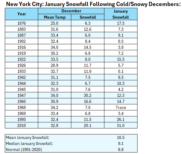
December 2025 will finish with a mean temperature below 35.0°C (coldest since 2010) and more than 6" of monthly snowfall. Below is how January fared in terms of snowfall following cold and snowy Decembers.
-
I see ~no chance for Dec ‘25 to come in warmer than Dec ‘39’s 37.7. Through the 27th (last widespread US warm day), MTD could rise to ~38.2. But 12/28-31 are progged to avg ~31. That would bring the full Dec back down to ~37.2.
-
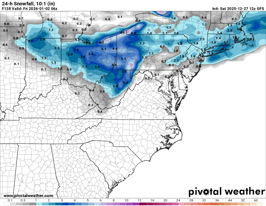
Agree. There were some runs with more of a meso low in the Gulf of Maine, but thats trended northward and slower to develop
-

January 2026 regional war/obs/disco thread
CoastalWx replied to Baroclinic Zone's topic in New England
I had a good season 21-22 but it’s been pretty bad here. Ever since then it’s been the epicenter of porkage. Hopefully we all have a good rest of the winter. -
-
I see ~no chance for Dec ‘25 to come in warmer than Dec ‘39’s 37.7. Through the 27th (last widespread US warm day), MTD could rise to ~38.2. But 12/28-31 are progged to avg ~31. That would bring the full Dec back down to ~37.2.
-

January 2026 regional war/obs/disco thread
Damage In Tolland replied to Baroclinic Zone's topic in New England
Starting NYD -
Micro analyzing op runs in the LR(or even worse, whining about MBY details) is futile and annoying. Folks gonna do what they do though.
-
January 2026 regional war/obs/disco thread
CoastalWx replied to Baroclinic Zone's topic in New England
Well euro has some chances