All Activity
- Past hour
-

The Jan 31 Potential: Stormtracker Failure or 'Tracker Trouncing
jayyy replied to stormtracker's topic in Mid Atlantic
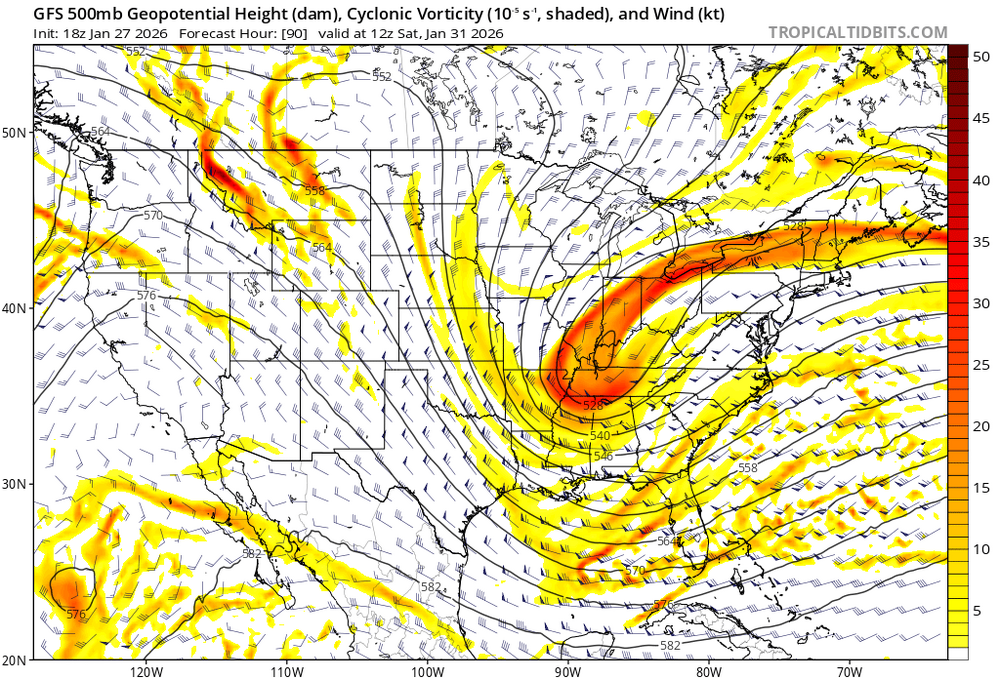
Yep. Same core as the GFS. Gfs should be solid -
I was wrong. My street and route was luckily plowed going out to the main roads. Took a detour throughout the neighborhood and many side streets were still not plowed as of 430. Usually the county gets good contractors but seems the ones this year aren't great. Still haven't seen any county plows around at all.
-

The Jan 31 Potential: Stormtracker Failure or 'Tracker Trouncing
stormtracker replied to stormtracker's topic in Mid Atlantic
Not super promising so far...may even be backsliding -

The “I bring the mojo” Jan 30-Feb 1 potential winter storm
StantonParkHoya replied to lilj4425's topic in Southeastern States
Please oblige me my hysterics. I have to go through it like a bloodletting. . -

The Jan 31 Potential: Stormtracker Failure or 'Tracker Trouncing
psuhoffman replied to stormtracker's topic in Mid Atlantic
My best guess looping the h5 and mslp is the nam was going to pull that low right up off VA beach or Norfolk then slide ENE based on how the flow was backing and where the upper low was about to cut off. -

The “I bring the mojo” Jan 30-Feb 1 potential winter storm
Orange county replied to lilj4425's topic in Southeastern States
NWS service not so bullish ih Raleigh Friday Night A chance of snow. Mostly cloudy, with a low around 18. Chance of precipitation is 50%. Saturday Snow likely, mainly before 1pm. Mostly cloudy, with a high near 24. Chance of precipitation is 60%. Saturday Night A chance of snow. Mostly cloudy, with a low around 14. Chance of precipitation is 40%. -

E PA/NJ/DE Winter 2025-26 Obs/Discussion
SNOWCREATURE1 replied to LVblizzard's topic in Philadelphia Region
Fascinating! Can I ask the source of the statement, and when it was issued or posted? Thanks. -

The “I bring the mojo” Jan 30-Feb 1 potential winter storm
btownheel replied to lilj4425's topic in Southeastern States
It’s NAM at 84. Bombing Miller A will have a really quick transition zone and temps will crash out quickly as it bombs. . -

The Jan 31 Potential: Stormtracker Failure or 'Tracker Trouncing
Nomz replied to stormtracker's topic in Mid Atlantic
https://efisher828.github.io/weathernext/ 12 hours delayed with limited maps but this is the best i know of -

Central PA Winter 25/26 Discussion and Obs
AccuChris replied to MAG5035's topic in Upstate New York/Pennsylvania
It is not exact, but it has some similarities to the “surprise” January 24-25, 2000 coastal. The H84 NAM 500mb map is closely similar to the 12z Jan 24 2000 500mb re-analysis. That storm dumped heavy snow in the Carolinas and Virginia, Maryland, Delaware and I remember eastern PA got between 8-14” . -

The Jan 31 Potential: Stormtracker Failure or 'Tracker Trouncing
Ralph Wiggum replied to stormtracker's topic in Mid Atlantic
If you ask it the same forecast outlook 20 times, it gives 19 different answers. Seems reliable to me. Just hug the forecast you like best. -

E PA/NJ/DE Winter 2025-26 Obs/Discussion
RedSky replied to LVblizzard's topic in Philadelphia Region
32" average Doylestown? -
 Iconic might come east of 18z Sent from my SM-S166V using Tapatalk
 -
Bout right there. I rarely get good snows in IMBY from a slp east of Hatteras. I still tend to think this is going to have to be home cooked northern stream energy at the end of the day - IF that is the slp location. But sometimes we get that lee side low which backs precip. For me, this is a little too finesse for my liking. Just need a good ol' fashioned low cranking 50 miles inland. Any energy handoff is almost always a problem for E TN.
-

The Jan 31 Potential: Stormtracker Failure or 'Tracker Trouncing
J.Mike replied to stormtracker's topic in Mid Atlantic
WWow, what a platform. Anyone know how to use it? -
The “I bring the mojo” Jan 30-Feb 1 potential winter storm
Orange county replied to lilj4425's topic in Southeastern States
-

The “I bring the mojo” Jan 30-Feb 1 potential winter storm
kvegas-wx replied to lilj4425's topic in Southeastern States
The overwhelming sense of modeling de javu should not be lost on this board. Not invested until the dropsonde data is ingested tomorrow. Thats when we went to sh*t last week. Show me model alignment on a Miller A on Thursday morning and I'll bite. In the meantime, add these runs to the digital snow thread. What a season! -

Richmond Metro/Hampton Roads Area Discussion
RVASnowLover replied to RIC Airport's topic in Mid Atlantic
It did look good. See if those 18z dropsounds make a difference in 00z suite -
I dont know, looks to me like the heights are even better for this than the GFS. Would think this would make it closer to the cost based on the 500's.
-
 Can we cut the chatbot quotes? I promise everyone it doesn’t know what it’s talking about.
 -
LOL, that isn't happening here until mid-June with all the west coast hockey playing.
-
Too late now! I'm riding or dying on this one its been too long
-
I want 2 feet to shut the whole shebang down!
-

The “I bring the mojo” Jan 30-Feb 1 potential winter storm
PackGrad05 replied to lilj4425's topic in Southeastern States
Meanwhile, all the Mets, including Brad P were saying cold air was locked and this would be snow or nothing. Surprised they say that stuff so early!!! . -
 NAM looked like it was about to crush us. so I went and looked on southernwx and it appears one guy downloaded 6 of the 68 member weathernext ensemble before the download glitched. He says all 6 look good for their region and the latest one he posted looks like a blizzard for us.


