All Activity
- Past hour
-

2026 Mid-Atlantic Severe Storm General Discussion
high risk replied to Kmlwx's topic in Mid Atlantic
Yeah, instability looks good at the end of the week. Thursday has enough deep layer shear to perhaps make it an interesting day for many. The flow Friday looks weak which would support very isolated severe. I'm *very* intrigued by multiple ensemble systems showing potential for deep trough to our west next week. -

E PA/NJ/DE Spring 2026 Obs/Discussion
RedSky replied to PhiEaglesfan712's topic in Philadelphia Region
Detailed Forecast This Afternoon Sunny, with a high near 79. Southeast wind around 5 mph. Tonight Clear, with a low around 54. Southeast wind around 5 mph becoming calm in the evening. -

Junorch obs and discussion 2026
Damage In Tolland replied to Damage In Tolland's topic in New England
Stein https://x.com/nwsnerfc/status/2064022127834026337?s=46&t=dhcbvkjmRcyBVQtDxJ3lRg -
Says the guy mainlining digital blue...
-
Roadtrip to Binghamton?
-
What's this talk about NYC hitting over 100 degrees by Friday??
-
https://mesonet.agron.iastate.edu/plotting/auto/?q=97
-
Head to eastern Iowa.. you have plenty of time

-
Could be here. Probably be evening though but can’t rule out afternoon stuff, especially west
-
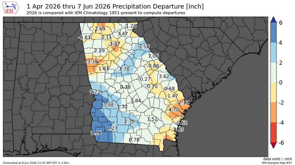
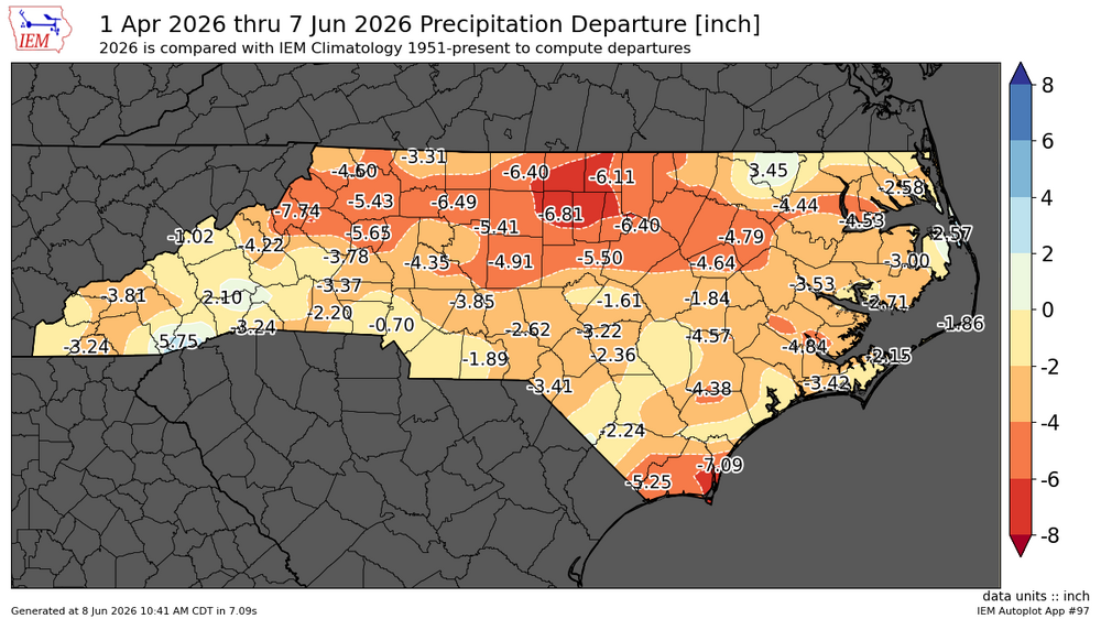
If we get the rain that is predicted over the next 10 days, the ATL area in general should be almost out of the drought. I sure hope everyone to our East and north East of us can cash in on some of this tropical moisture.
-
Maybe WNE for Thursday, otherwise meh.
-
Maritime influence
- Today
-
Overcast with noon sprinkles in Columbia, 71°.
-
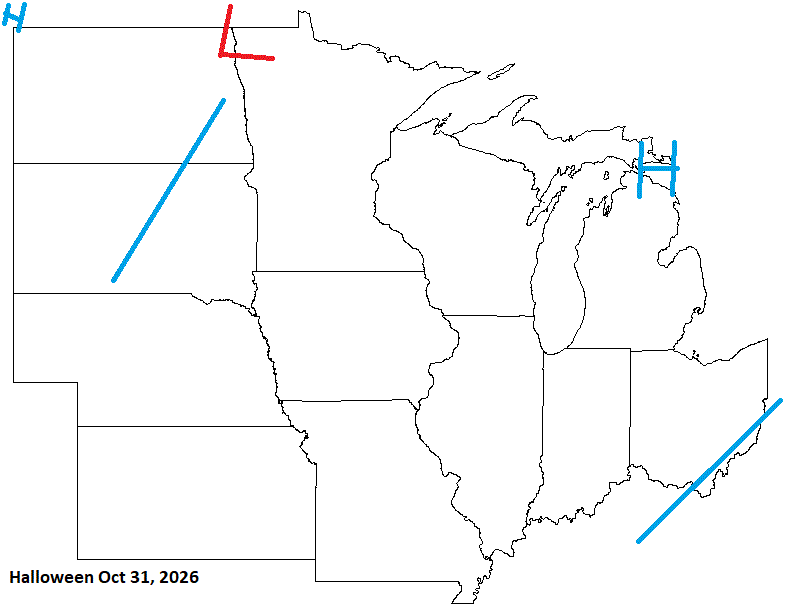
Halloween looks good for some, but late Oct looking unsettled.
-
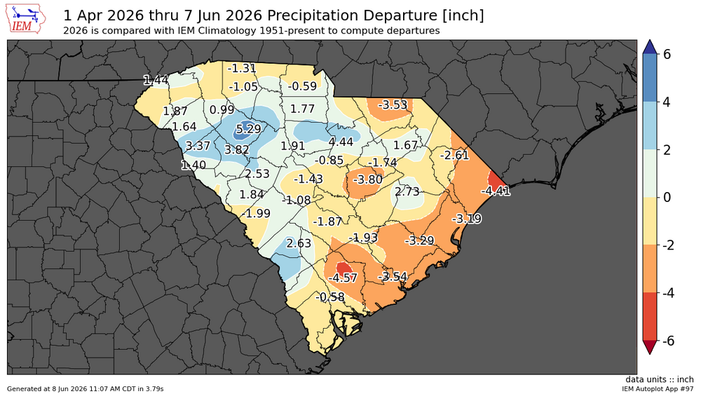
Do you have this map for other states in the SE? TIA
-
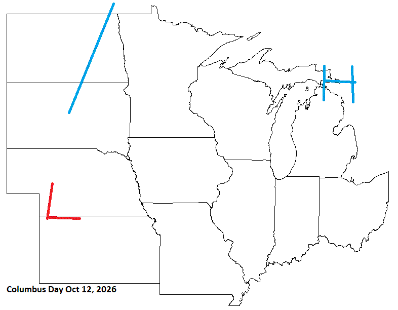
Columbus Day looks decent with inclement wx.
-
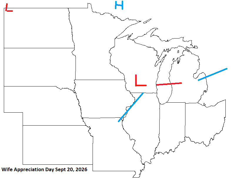
Wife Appreciation Day just before the Fall Equinox looks unsettled with some energy moving through the sub. Ok husbands, you know what to do today (I hope).
-
Reggie might be fun though
-
Midwest im guessing.. nothing seems interesting here
-

2026-2027 Super El Nino
GaWx replied to Stormchaserchuck1's topic in Weather Forecasting and Discussion
Thanks, Chris -Long range model winter forecasts have, indeed, tended to be too cold on average based on my recollection although the Euro has missed on both sides. So, I wouldn’t be shocked if 25-6 also comes in warmer than today’s forecast, but that remains to be seen. -But keep in mind that you essentially are showing a super Nino sample size of just one (2015-6 done in August) since 2023-4 wasn’t a true super (RONI peaked at only +1.49). ONI had ~0.5C excess due to very warm surrounding tropical waters from GW inflating the ONI. -Also, other super Ninos had a fairly similar temp. pattern to what the NMME shows overall. -

2026-2027 Super El Nino
mitchnick replied to Stormchaserchuck1's topic in Weather Forecasting and Discussion
Nobody is forcing anyone to consider any model. But if someone posts a model's SSTA forecast, what's so wrong or unusual about posting it's resulting weather forecast. It's done all the time. -
2026-2027 Super El Nino
mitchnick replied to Stormchaserchuck1's topic in Weather Forecasting and Discussion
The weather is what counts, and I'm not seeing anything different than previous extremes being forecasted by the same models forecasting your "global climate disruption." In fact, there's yet to be an agreement on the resulting weather. -
-

2026-2027 Super El Nino
forkyfork replied to Stormchaserchuck1's topic in Weather Forecasting and Discussion
we're facing the biggest global climate disruption of our lives -

2026-2027 Super El Nino
LakePaste25 replied to Stormchaserchuck1's topic in Weather Forecasting and Discussion
Why would I even look at what models are showing next winter with more than a grain of salt when it’s only June? I am focused on how this is developing and summer analogs. I will check on that in October.


.thumb.gif.f92b16c631a1d15d405ed77b33f0710d.gif)


