All Activity
- Past hour
-
He may of thought those were minus marks before the numbers Larry.
-

Central PA Winter 25/26 Discussion and Obs
Itstrainingtime replied to MAG5035's topic in Upstate New York/Pennsylvania
Sunday's potential is showing some signs of coastal enhancement in eastern PA - have to admit, I don't hate this look: -
Piling up.

-
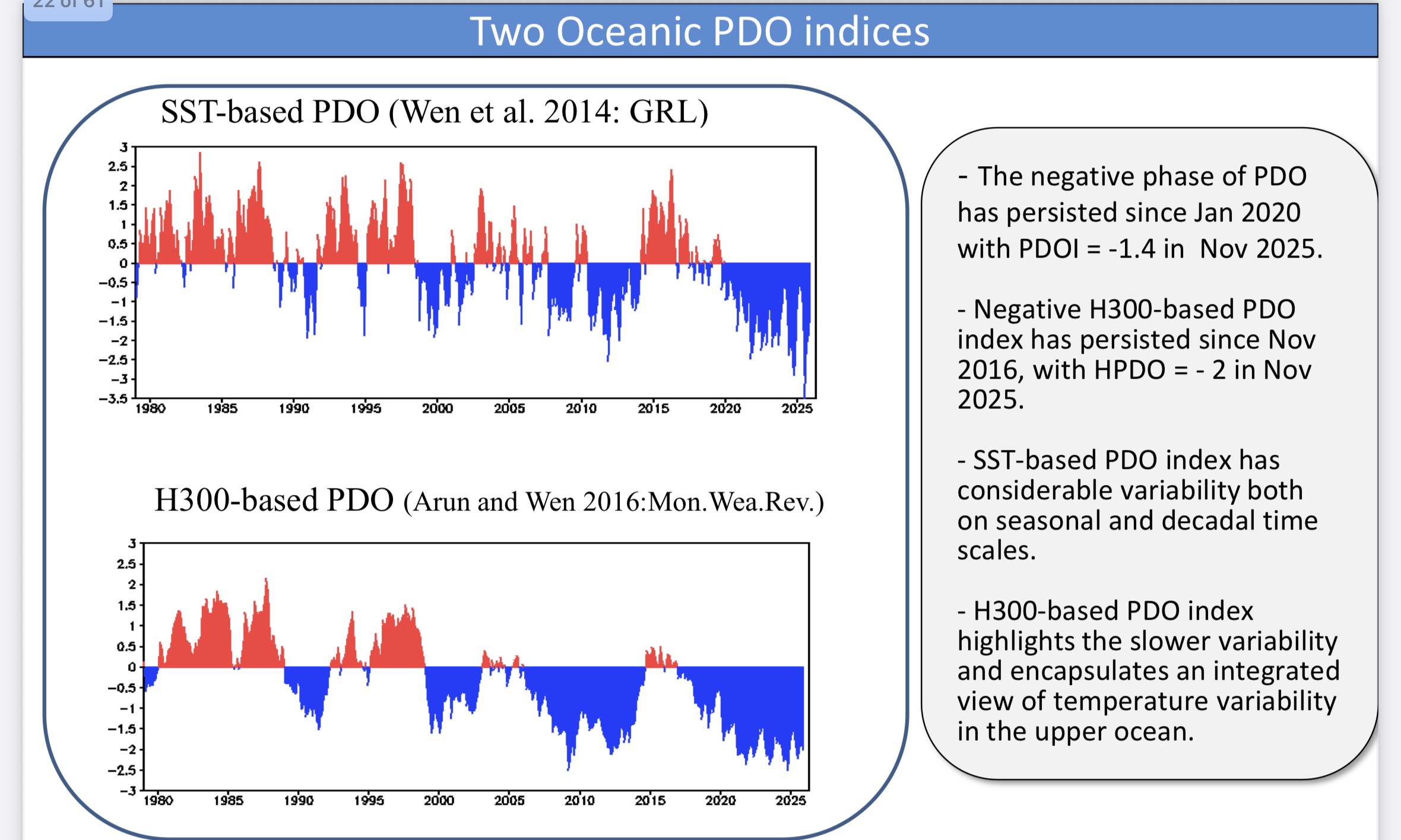
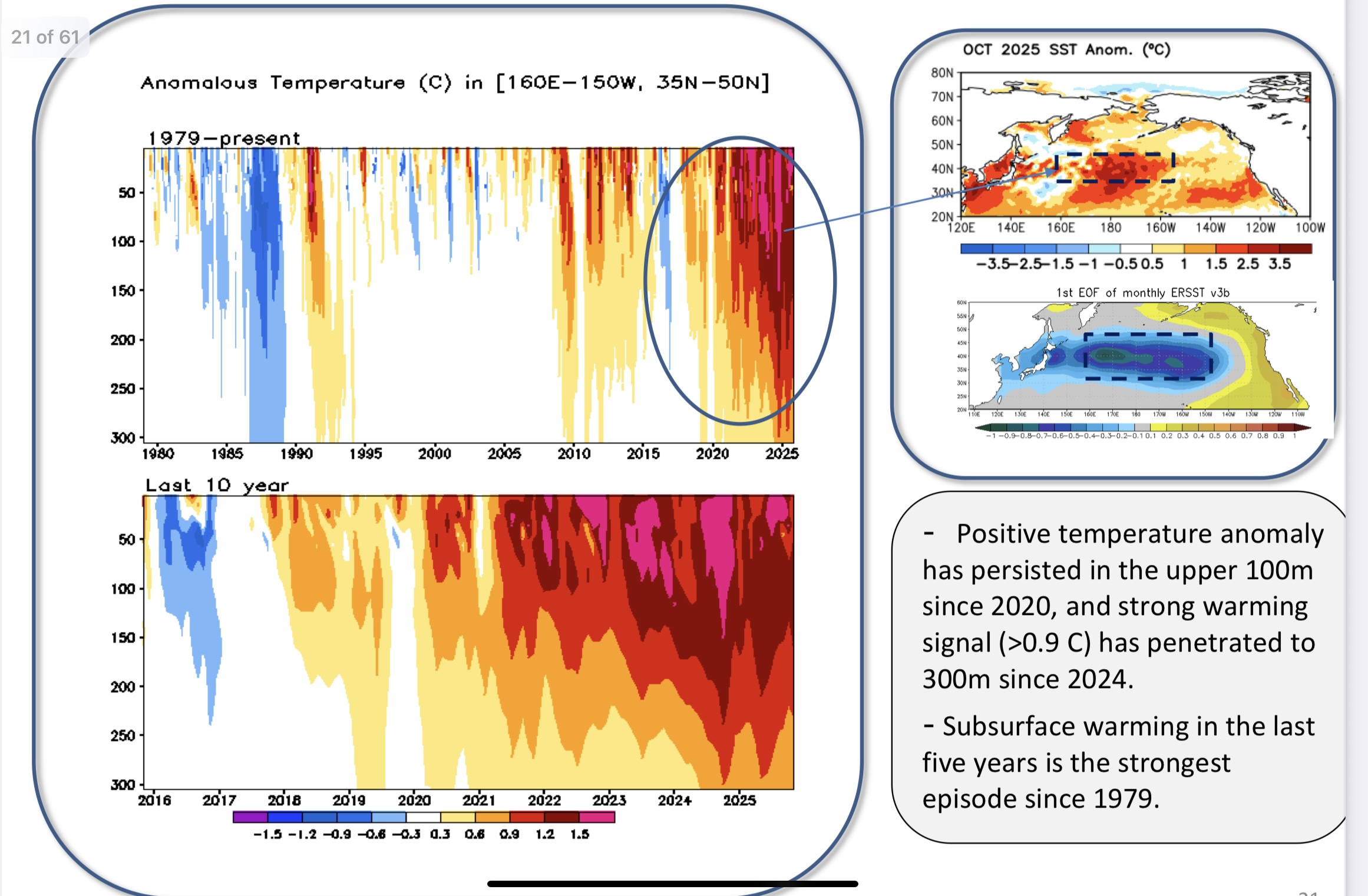
The greater issue is the rapid subsurface warming across the Western Pacific mid-latitudes. This resembles more of a shift rather than a function of the old PDO cycles that we have become familiar with in the past. The new subsurface and H300 PDO index does a better job reflecting the magnitude of the shift. https://www.cpc.ncep.noaa.gov/products/GODAS/ocean_briefing_gif/global_ocean_monitoring_current.pdf


-
.thumb.png.4150b06c63a21f61052e47a612bf1818.png)
December 2025 regional war/obs/disco thread
HIPPYVALLEY replied to Torch Tiger's topic in New England
Light snow in Greenfield now. Not expecting anything out of it though. -

E PA/NJ/DE Winter 2025-26 Obs/Discussion
LVblizzard replied to LVblizzard's topic in Philadelphia Region
I live essentially right on I-78, I can hear it from my place. It's currently a rain/snow mix. Not sticking and I doubt it will. Still nice to see something other than rain. -
Hey troll, I didn’t say these were anywhere near historic. The record lows for 12/15 at RDU/ATL are way down at 8/11. But these are ~18 BN.
-
bah humbug! there's skiing to do
-

E PA/NJ/DE Winter 2025-26 Obs/Discussion
Tatamy replied to LVblizzard's topic in Philadelphia Region
Check out the current feed on the traffic cams along 78 west of Allentown. It’s precipitating only it’s not rain. -

December 2025 regional war/obs/disco thread
WinterWolf replied to Torch Tiger's topic in New England
You’re starting to sound alot like TBlizz…chin up bro…it’s only 12/10. -

Mid to long range discussion- 2025
Akeem the African Dream replied to wncsnow's topic in Southeastern States
that would be historic -
10+ day maps should be weighed lightly, in either warm or cold directions, in my opinion.
-

December 2025 regional war/obs/disco thread
Torch Tiger replied to Torch Tiger's topic in New England
-
December 2025 regional war/obs/disco thread
WinterWolf replied to Torch Tiger's topic in New England
This thing is still 3.5 days out …you don’t think there’s enough time to trend this a 100 miles? Geez Paul, I think we all know that’s very doable at this juncture for sure. But maybe you’ll be right? Gonna be a fun couple days seeing how this turns out. -
If Pensacola and New Orleans can have a MECS/Blizzard we are quite a ways away from no snow around here...
-
I'm heading up to Kingston for an event this evening. I assume the thruway will be no worse than wet. Any intelligence to the contrary?
-
I bet it won't play out like that...not this year. 70s I would believe however.
-
Nah dude. Its so warm now it will never snow again. Walking around in shorts and flip flops all the time drinking pina coladas. Sun angle is a constant threat too. It never gets cold enough to snow. Those days are behind us. You know, background state. oh wait…

-

December 2025 Short/Medium Range Forecast Thread
Daniel Boone replied to John1122's topic in Tennessee Valley
As usual, got some decent Year's snow wise but some not so good as well. One great one (2011) One terrible (1990) . -
Looks like a burst of rain and snow coming... probably elevationally dependent. Bright banding evident on radar.
-
A tradition unlike any other!
-
Latest Natty Blend. At this range its a great tool to use for guidance.
-

Winter 2025-26 Short Range Discussion
ChiTownSnow replied to SchaumburgStormer's topic in Lakes/Ohio Valley
I like the optimism.. need to will it to happen -
This has nothing to do with the SAI. The most recent 30 year data reflecting the warmer climate leaves no doubt as to the relationship. Back in the colder climate era the relationship was much weaker than it has become. Part of this is due to weather patterns becoming more repetitive in a warmer climate probably owing to local tropical SSTs resulting in non-linear convective temperature forcing thresholds being crossed. I understand that the most extreme warming has only occurred over the last 15 to 30 years. So we have a new emergent climate state that is different from the previous colder era. We don’t have the luxury anymore of a relatively stable global temperature regime as was the case from 1880 through 1982. So you had a much longer period where there was only a small increase in temperatures. It gave us a 100 years of correlations to work out and use. I understand that you may have some hesitancy in using the newer correlations derived over the shorter period. But I have been using numerous relationships from this new and warmer period that have been serving me well. But it’s not a 100 year data set to draw from like we had back in the older and colder climate era.
-
Scrolling down my past posts and found these gems: