All Activity
- Past hour
-
Ok peeps, time for 0z and forget about the Euro. NAM is running, onward and forward we go…
-
High of 27 15 at 9PM 10 will probably be the low. Burning some of that wood I split yesterday. Toasty in here. Heat pump on vacay.
-
And I've named them: TWC The Weather Crap
-
January 25/26 Jimbo Back Surgery Storm
digital snow replied to Jimbo!'s topic in Southeastern States
It is my 4th season back in NC. Much appreciation to the SE crew! Everything is still on the table. edit: I remember being in NC in the Walmart in 2008 when they just got tv screens that showed the weather above the check outs. We were forecasted to get 12-16" and the screen flashed to 33 degrees and rain while I waited in line to buy my ice cream. F that -

Richmond Metro/Hampton Roads Area Discussion
mikeeng92 replied to RIC Airport's topic in Mid Atlantic
Seems like the seasonal trend has been for these northern stream vorts to deamplify, miss phasing. But this is a different setup so we’ll see. Whoever gets the freezing rain is absolutely screwed with cold air on the backside. -

Central PA Winter 25/26 Discussion and Obs
Blizzard of 93 replied to MAG5035's topic in Upstate New York/Pennsylvania
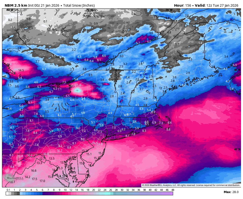
Here is latest NBM National Blend
-
I found another fellow weather nerd in chemistry class today. we talked about severe wx ingredients while we finished our periodic table and electron configuration lab today. he has his own FB weather page. I went back to community college and we are aiming for the same degree (meteorology).
-
17/-2 here Definitely cold either way lol
-
The Weather Channel has named this storm. It's called Winter Storm Fern.
-

Winter 2025-26 Short Range Discussion
SchaumburgStormer replied to SchaumburgStormer's topic in Lakes/Ohio Valley
Heavy virga warning in effect -
They wanted 2015, they got it! But forgot the price...winters in the Mid Atlantic. Lol
-

Pittsburgh/Western PA WINTER ‘25/‘26
Burghblizz replied to Burghblizz's topic in Upstate New York/Pennsylvania
Less clown maps in those days. It was a lot of looking at the QPF and assuming. I remember seeing 2.5” or so modeled at one point. -

January 25/26 Jimbo Back Surgery Storm
Thrasher Fan replied to Jimbo!'s topic in Southeastern States
Not exactly for our region on this board but the GOAT has put out some Tuesday thoughts on the coming storm. https://x.com/spann/status/2013795951081644345?s=20 -
What’s the 00z NBM totals look like?
-
Eps Ensemble drops Totals here to just 3-4" of slop. Shoots that warm nose all the way to the Ky, Va, WV Border.
-
Well it's cousin 12K NAM is hot on its heels.
-

January 2026 regional war/obs/disco thread
ineedsnow replied to Baroclinic Zone's topic in New England
0z NAM upping even a bit more for tomorrow night -
I was thinking Thursday but could also do Friday to make sure we aren’t celebrating too prematurely, lol. I’ve got no real preference
-
@psv88i think it’s fair to agree it’s cold; no one said historic cold. It’s frozen lung cold out this way; just came in with the dog. 8/-3; colder than last night already.
-

Possible Record Breaking Cold + Snow Sunday 1/25 - Tuesday 1/27
Dan76 replied to TriPol's topic in New York City Metro
Same here snow was packed down from the wind got stuck more times than than ever. -

January 25/26 Jimbo Back Surgery Storm
Brick Tamland replied to Jimbo!'s topic in Southeastern States
Greg Fishel posted his thoughts on Facebook. https://www.facebook.com/share/v/1B1YSQQaRK/ -
Bruh that thing can't even get 48 seconds right!
-

Occasional Thoughts on Climate Change
TheClimateChanger replied to donsutherland1's topic in Climate Change
I don't agree with you all that often, but this is very true. Ratio moving rapidly in the direction one would expect. Although I must note that the chart itself is also "rigged" in a few ways to produce an incomplete picture. I'm assuming, of course, it's accurate. Who knows about station selection, have to assume all stations meeting the criteria were selected. (1) Martz only posts the first time a record was set and ignores later ties. This, of course, produces a bias for both record highs and lows towards the early years - which we can plainly see. The dropoff in highs (and, to an extent, lows) would not be as dramatic otherwise. (2) The data is unadjusted. Most of the GHCN stations switched from afternoon/evening observation times (5/6 pm) to morning observation times (~7 am), which is the time in which the instruments would have been manually reset. While maybe not a huge factor, this favors occasional "double" counting of record highs up through the mid 20th century and occasional "double" counting of record lows thereafter. (3) Unclear what direction this bias goes. But it should be noted that a more complete picture would be rendered by indicating the percentage of total data available for each year. The criteria was for stations that reported at least 85% data for 100 years - but where is the missing data. If there is station dropoff towards the end, then that also contributes to the general "softening" of the records. Like I said, this information wasn't presented so I can't so for sure what effect, if any, this has. But I can say for certain that presenting that data would be helpful for presentation. Regardless of the rigging, the data is fully consistent with a warming climate - record highs are clearly outpacing record lows. The apparent loss of extremes in both directions from the earlier decades is largely (maybe not entirely, but significantly) affected by the convention to list only the first occurrence of a record high or low. That choice necessarily will produce a dynamic where earlier decades show more record-breaking temperatures than later decades. -
Believe me, its real