All Activity
- Past hour
-
This winter shall be called: "the winter of the hybrid clippers" My favorite type of setup
-

November 2025 general discussions and probable topic derailings ...
powderfreak replied to Typhoon Tip's topic in New England
Yeah those 1500ft+ spots should clean up. Even 1,000ft out that way. -
-
-
a bit of a side note on weather. Louisville airport reported smoke after the plane crash
-

Central PA Fall Discussions and Obs
pawatch replied to ChescoWx's topic in Upstate New York/Pennsylvania
The wind is just a blowing and the leaves keep falling. Got a mow in today, mostly grass and a few leaves. probably next one I will be bagging. -

E PA/NJ/DE Autumn 2025 Obs/Discussion
Birds~69 replied to PhiEaglesfan712's topic in Philadelphia Region
YEEHAW! (61F/Expected low 41F)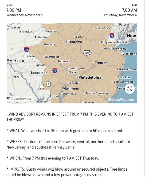
-
The November Euro seasonals are in. January looks decent. December could likely be colder than what it depicts, ESPECIALLY if the Euro weeklies from today are correct. Those weeklies look frigid through mid month. Warm Feb-April. But if we get Dec-Jan, we take it an run.
-

November 2025 general discussions and probable topic derailings ...
dendrite replied to Typhoon Tip's topic in New England
Yeah looks like there could be some decent accums in the slightly higher terrain in Coos and adjacent ME tonight. -
As of 4 pm, the high temperature in New York City had reached 66°. That was a full 2 standard deviations above the NBM forecast from 11z, a remarkable bust. Newark was even warmer with a high of 70°. However, this warmth will be short-lived, as a cold front is now crossing the region. In doing so, it could trigger some widely scattered showers. Most areas will remain dry. The first half of tonight will be very windy. Winds will likely gust past 50 mph for several hours. Afterward, winds will slowly diminish. Highs will then fall back to the lower and middle 50s tomorrow and middle and upper 50s on Friday. The weekend will be mild with Saturday being the warmest day. Highs on Saturday will likely reach the lower and perhaps middle 60s. Newark could again approach or reach 70°. A strong cold front will then bring this season's coldest temperatures so far early next week. Lows would fall well into the 30s in New York City while highs struggle to reach the middle and upper 40s. The ENSO Region 1+2 anomaly was +0.1°C and the Region 3.4 anomaly was -0.6°C for the week centered around October 29. For the past six weeks, the ENSO Region 1+2 anomaly has averaged -0.05°C and the ENSO Region 3.4 anomaly has averaged -0.52°C. La Niña conditions will likely continue through mid-winter. The SOI was +26.97 today. The preliminary Arctic Oscillation (AO) was +0.140 today.
-
November 2025 general discussions and probable topic derailings ...
powderfreak replied to Typhoon Tip's topic in New England
We snow.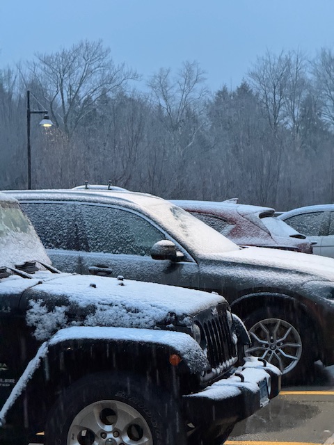
-

Overnight Wednesday, November 5, 2025 Wind Event
Torch Tiger replied to weatherwiz's topic in New England
Max gusts dropped from like 45mph to 40 here. Nbd -
I got a real easy approach to tracking this year: If a model shows something that hasn't happened in 10 years...assume it's wrong and toss it
-
Nah we haven't had the pattern with a less hostile PDO though. The -PDO regime has been a constant the last 10 years. It finally eased up close to positive for a moment last season and lo and behold...we squeezed out more flakes. Not blockbuster by any stretch, but slightly better.
-
 NWS had Storm Watch here for Marine now just Gale warning.
 -

November 2025 general discussions and probable topic derailings ...
H2Otown_WX replied to Typhoon Tip's topic in New England
Euro and GFS are worlds apart past D8-9 but unfortunately the GEFS doesn't seem to support the GFS idea of reloading the PNA ridge. I must not understand the PNA domain because the forecast for the next week on the teleconnections site shows it as neutral despite the huge ridge developing this weekend/early next week. - Today
-
That rule got changed a few years ago (2018 I want to say?) but it's not retroactive. So the T snow in July stays.
-

Best Mid-Atlantic winter storm of the last 50 years
wxmeddler replied to PrinceFrederickWx's topic in Mid Atlantic
Feb 5-6 for sure at least in the past 25 years. As I type that, I realize that's since 2000 and now I feel very old. Anyway, Feb 5-6 was the cake and Feb 9-10 on top was just extra icing. PDII of 2003 is #2. Wasn't on the east coast for '96 or '93 unfortunately. -
 There has been some small decrease in modeled winds tonight... I think the advisory covers it. 45 KT at BUF recently at 40 KT JST. Slowly increasing,
 -
 Gotcha, thanks. We had a High Wind Watch issued up here yesterday that went to a Wind Advisory.
 -
I'm starting to thing that this snow system depends a lot on timing. If it happens at say 7PM then temps will likely be too warm except for the upslope areas (around 40+), but if it happens at say 10PM then temps are more like 35... much more conducive for snow
-

November 2025 general discussions and probable topic derailings ...
dryslot replied to Typhoon Tip's topic in New England
So did mine but its also my mower in the summer............ -
November 2025 general discussions and probable topic derailings ...
powderfreak replied to Typhoon Tip's topic in New England
Wet snow falling at 1,500ft outside my window. -
November 2025 general discussions and probable topic derailings ...
dryslot replied to Typhoon Tip's topic in New England
Yes, WCSH6 is News Center Maine, And WMTW8, I speak to both of those stations mets with my spotter reports. -
 My snowblower starts—winter cancel.


