All Activity
- Past hour
-

Southern MD / Lower Eastern Shore weather discussion
PrinceFrederickWx replied to PrinceFrederickWx's topic in Mid Atlantic
The main thread went from Eeyore to weenie in about 15 hours. -

The “I bring the mojo” Jan 30-Feb 1 potential winter storm
NC_hailstorm replied to lilj4425's topic in Southeastern States
Canadian is neutral tilt at 90,and also a tick west of 12z. -
 How the f?
 -

Possible coastal storm centered on Feb 1 2026.
Spanks45 replied to Typhoon Tip's topic in New England
Unless we get a weenie band out here, I dont recall a storm that gave me large amounts of snow, that far out. On a side note, this snow pack, along with clear calm conditions is doing its work. Already -1⁰. We can keep the snow, get more of it, but maybe be a bit warmer too? -

The Jan 31 Potential: Stormtracker Failure or 'Tracker Trouncing
wxdude64 replied to stormtracker's topic in Mid Atlantic
-

The Jan 31 Potential: Stormtracker Failure or 'Tracker Trouncing
Ji replied to stormtracker's topic in Mid Atlantic
I would rather me not get 9 if someone gets 40 in NC -

Possible coastal storm centered on Feb 1 2026.
Snowcrazed71 replied to Typhoon Tip's topic in New England
Why the tend West on the GFS and east on the CMC? Very frustrating to say the least -

The “I bring the mojo” Jan 30-Feb 1 potential winter storm
BornAgain13 replied to lilj4425's topic in Southeastern States
CMC apparently had feedback issues. -

The Jan 31 Potential: Stormtracker Failure or 'Tracker Trouncing
jayyy replied to stormtracker's topic in Mid Atlantic
That was the retaliatory tariff version of the CMC -

The Jan 31 Potential: Stormtracker Failure or 'Tracker Trouncing
Solution Man replied to stormtracker's topic in Mid Atlantic

-

The Jan 31 Potential: Stormtracker Failure or 'Tracker Trouncing
AlexD1990 replied to stormtracker's topic in Mid Atlantic
sounds like maybe it had a hard time trying to resolve the double barrel low structure. -

The “I bring the mojo” Jan 30-Feb 1 potential winter storm
WXNewton replied to lilj4425's topic in Southeastern States
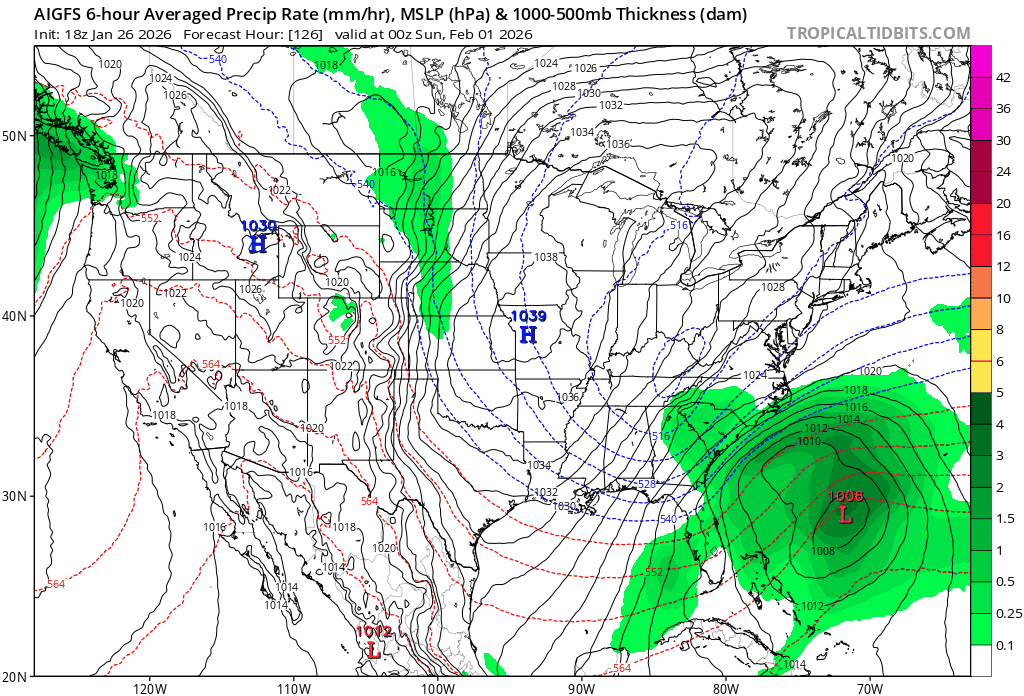
00z AI GFS trending west each run...Here's the last 6 runs.
-

The “I bring the mojo” Jan 30-Feb 1 potential winter storm
Buddy1987 replied to lilj4425's topic in Southeastern States
Canadian looked SUPER funky. Almost like convective feedback issues or some weird crap. It like merged the two storms together in the Atlantic and created like a damn typhoon lol. -

Richmond Metro/Hampton Roads Area Discussion
RVASnowLover replied to RIC Airport's topic in Mid Atlantic
CMC was a wild, interesting run. -
Really need to see some positive trends tomorrow or it’s going on life support
-

The Jan 31 Potential: Stormtracker Failure or 'Tracker Trouncing
paulythegun replied to stormtracker's topic in Mid Atlantic
I'm guessing we didn't give the Canadians our recon plane data. They never ingested it. Whereas, in contrast, GFS' belly is full -

2025-2026 Fall/Winter Mountain Thread
Sw NC weather replied to Buckethead's topic in Southeastern States
A solid 4-7” thump on the CMC. I think I’m gonna call it a night. Here’s to good trends tonight. -

Pittsburgh/Western PA WINTER ‘25/‘26
SteelCity87 replied to Burghblizz's topic in Upstate New York/Pennsylvania
Just need it to come west and then have the precip shield blow up in later runs lol. At this point I feel like an addict. I'll take anything we can get to fill the gap to our next storm lol. Fiending for flakes. -

The “I bring the mojo” Jan 30-Feb 1 potential winter storm
BooneWX replied to lilj4425's topic in Southeastern States
Greed is an ugly thing -
The Jan 31 Potential: Stormtracker Failure or 'Tracker Trouncing
jayyy replied to stormtracker's topic in Mid Atlantic
That was a wonky run of the CMC -

The Jan 31 Potential: Stormtracker Failure or 'Tracker Trouncing
wasnow215 replied to stormtracker's topic in Mid Atlantic
Blizzard warning for some on 0z GFS? -
That can actually be somewhat possible with the potential energy with this storm.
-

Winter 2025-26 Short Range Discussion
michsnowfreak replied to SchaumburgStormer's topic in Lakes/Ohio Valley
Some hit and miss squalls today dropped 0.4" and drifted some of the snowcover around. 13 of the past 14 days saw measurable snowfall. The lone holdout was Jan 20 with just a T. Deep winter continues. -
 Nah, that was contaminated by having the initial low way out to sea... Something tells me the CMC ENS would be bigger Sent from my SM-S166V using Tapatalk
 -
 Yeah, bring that 27 on over to Richmond and bump yalls totals up too