All Activity
- Past hour
-
2:36 pm
-

January 2026 Medium/Long Range Discussion
SomeguyfromTakomaPark replied to snowfan's topic in Mid Atlantic
Yeah as others have noted if every op run doesn’t show an HECS for their backyard they panic, but yeah we have the pattern in good shape going into prime climo so let’s just see if we can something to hit. -
It's too soon to pin down events or dates, but not too soon to be looking at these: https://www.tropicaltidbits.com/analysis/models/gfs/2025122912/gfs_mslp_pcpn_frzn_eu_40.png
-
Came back to Toronto for the holidays. We got 4" back on the 26th, so close enough for a white christmas YYZ at 23.1" for the season. Cold and windy today with on and off snow squalls. Had some melting with the rain last night, but still got a decent 2-3" of cement on the ground. Merry Christmas everyone!
-

December 2025 regional war/obs/disco thread
TripplePhaser replied to Torch Tiger's topic in New England
Same in Kittery! -

Ice Ice Baby December 28-29 Storm Discussion
WxWatcher007 replied to Baroclinic Zone's topic in New England
Let’s say it’s 24-30” with 70mph winds. -
Ice Ice Baby December 28-29 Storm Discussion
WxWatcher007 replied to Baroclinic Zone's topic in New England
Heading back to the icebox. Down to 32.6 after hitting 40.5° at 9am. Snowing here now. -
12Z ensemble means update for late week 2: good news overall for E US cold and also snow lovers: 1. GEFS H5 improved somewhat vs 0Z/6Z with a slightly higher PNA though it’s still a -PNA. The best news is that it’s significantly colder with BN temps and it’s snowier in much of the region. 2. EPS is very similar to the 0Z, which makes that good news. No caving whatsoever to the ugly 0Z/6Z GEFS.
-
Very, very encouraging 12z suite. They are all taking shots at us in the second week of Jan. All it takes is one to hit.
-

Pittsburgh/Western PA WINTER ‘25/‘26
colonel717 replied to Burghblizz's topic in Upstate New York/Pennsylvania
Nice, Pgh area upped to 4-6 range through Thursday am. I am sitting at about 1/3 inch so far today. Have lucked out with the snow sitting over my area.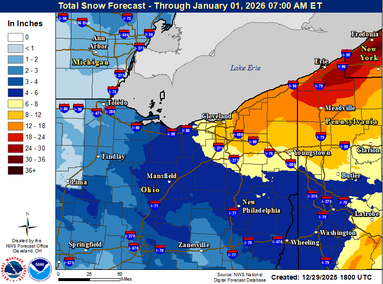
-

Ice Ice Baby December 28-29 Storm Discussion
Cold Miser replied to Baroclinic Zone's topic in New England
Depends on how much snow falls (fell). Blizzards don't always translate to monster amounts of snow, so yeah, keep the wind and give me a monster accumulating snow storm. -
Ha, just saw the euro AI. Those surface temps are a joke. Hr 252 is particularly comedic.
-

E PA/NJ/DE Winter 2025-26 Obs/Discussion
Birds~69 replied to LVblizzard's topic in Philadelphia Region
Hopefully leftover Christmas junk isn't booze. That's against certain religions in these neck of the woods. Save it for New Year's Eve or Birds game...good heavens. Winds really starting to kick in.... -
January 2026 regional war/obs/disco thread
Cold Miser replied to Baroclinic Zone's topic in New England
What minimal medium and short range stuff that I see is showing me pretty much the same shit pattern we've been having. Cold...(maybe a small snow event)...Rain...Repeat. Any signs that this is changing for something better for snow chances? -
Yep it's a decent look but honestly last year looked better at this stage.
-

Central PA Winter 25/26 Discussion and Obs
canderson replied to MAG5035's topic in Upstate New York/Pennsylvania
Powers out. 59 highest gust so far - but tons in the 50s. These gusts are lasting 15-20 secs too. I hit 49 for a high, now at 45. Gorgeous Sky overhead. -
I believe that FAA guidelines for airports still include wiping board every 6 hours, but all others pay cash. NWS observers, coops, etc., should clear the board once per day and report the max depth on the board between clearings. Stuff lives forever on the Internet and there's a lot of confusion, but I think that is the current practice. Personally, I wipe my boards at midnight, which is out of sync with my ~9am rainfall observation, but that's probably for the best here.
-

Ice Ice Baby December 28-29 Storm Discussion
DavisStraight replied to Baroclinic Zone's topic in New England
Its gonna turn to ice if enough of it sticks around. -

Ice Ice Baby December 28-29 Storm Discussion
mahk_webstah replied to Baroclinic Zone's topic in New England
Well, this is certainly not been a top level ice storm, but I would also say it’s a little bit higher than run-of-the-mill. There’s still slush on the roads, which I thought would’ve been gone by now and the trees have a pretty thick cover similar to that picture that lurker contributed. No significant loss to the snowpack just compressed and full of water. Looking at the forecast, we may not see this snow again until March once we get a couple of inches on top of it. 32° on the nose here. -

Central PA Winter 25/26 Discussion and Obs
MAG5035 replied to MAG5035's topic in Upstate New York/Pennsylvania
That’s right around where I bottomed out about 7-8am this morning (about 993.2mb). Up to almost 999mb now. -
That was quick
-
Not as applicable to our latitude, but saw Buffalo gusted to 79 mph (though I see 75 mph, so not sure if the 79 is legit).
-
It’s like people haven’t lived here their entire lives and aren’t aware that we pretty much never get wall to wall cold and snow lol. Oh no… two weeks of transient weather before a pattern shift… how awful [emoji1787] Switching over to a solid pattern from mid January through early February is about as perfect timing as it gets.
-

Ice Ice Baby December 28-29 Storm Discussion
ineedsnow replied to Baroclinic Zone's topic in New England
Wet snow stuck to trees then big gust came in? Thats awesome! -
Central PA Winter 25/26 Discussion and Obs
MAG5035 replied to MAG5035's topic in Upstate New York/Pennsylvania
46.1 mph is the high gust so far on my gauge at home, which is already higher than anything it got from the other Friday’s high wind warning. For high gusts so far at official stations I’m seeing 54mph at MDT, 56mph at CXY, 50mph at AOO, 45mph at UNV, 64mph at JST, 62mph at LBE and 58mph at DUJ