All Activity
- Past hour
-

Central PA Spring 2026 Discussion/Obs Thread
anotherman replied to Voyager's topic in Upstate New York/Pennsylvania
The rain is needed, so is cooler weather. This isn't July. -
-

E PA/NJ/DE Spring 2026 Obs/Discussion
Albedoman replied to PhiEaglesfan712's topic in Philadelphia Region
well, at this point, I will take any rain that falls today. We are in trouble folks as the gulf moisture is getting sucked away from these back door cold fronts and the timing is god awful. Where are the stationary fronts with the shortwaves riding the front and us being on the warm side of the front days? -

Central PA Spring 2026 Discussion/Obs Thread
Voyager replied to Voyager's topic in Upstate New York/Pennsylvania
Nasty day so far. Rainy, raw, and of course...windy. -
I don’t mean to brag but I recorded .11” of rainfall this morning. I’m now planning to get a lottery ticket when I’m out.
-
Strong sun and low 50s quite pleasant but ready to warm back up
-

Central PA Spring 2026 Discussion/Obs Thread
canderson replied to Voyager's topic in Upstate New York/Pennsylvania
Yea I called that way too early. To my credit last night the line was falling apart rapidly. I’m at .28”. -
Central PA Spring 2026 Discussion/Obs Thread
anotherman replied to Voyager's topic in Upstate New York/Pennsylvania
.58 here in York and radar still looks good. -
Been a recurring theme over the last couple springs/summers
-
11w/m^2 at 830am. I’m surprised the IR hasn’t kicked on for my outdoor cameras.
-
For my area, sure its been hot. But the humidity has been very low. These temps are tolerable with the low humidity. Front came through early this morning, feels like Fall. 47 degrees with 20MPH winds. ZERO rain with it though. The GA red clay dustbowl continues. Oaks dropping leaves already
-
Let’s ruin next weekend too.
-
29° with flurries here in Wolf. Quite a shock to the system! Sent from my Pixel 10 Pro using Tapatalk
-
Front just came through....ZERO precip. Starting next Saturday though looks like an actual chance for some real precip for a few days! One can dream.
- Today
-
Dusting of snow on elevated surfaces. Winters last gasp.
-
Dry pavement in Silver Spring, hoping we get smacked later by heavy rains
-

Central PA Spring 2026 Discussion/Obs Thread
Mount Joy Snowman replied to Voyager's topic in Upstate New York/Pennsylvania
Current temp of 48 is the low. .23” of precip with a bit more on the way. -
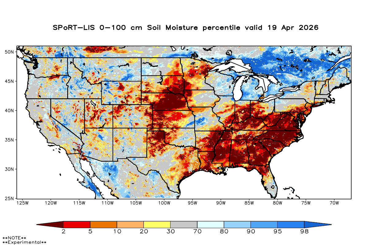
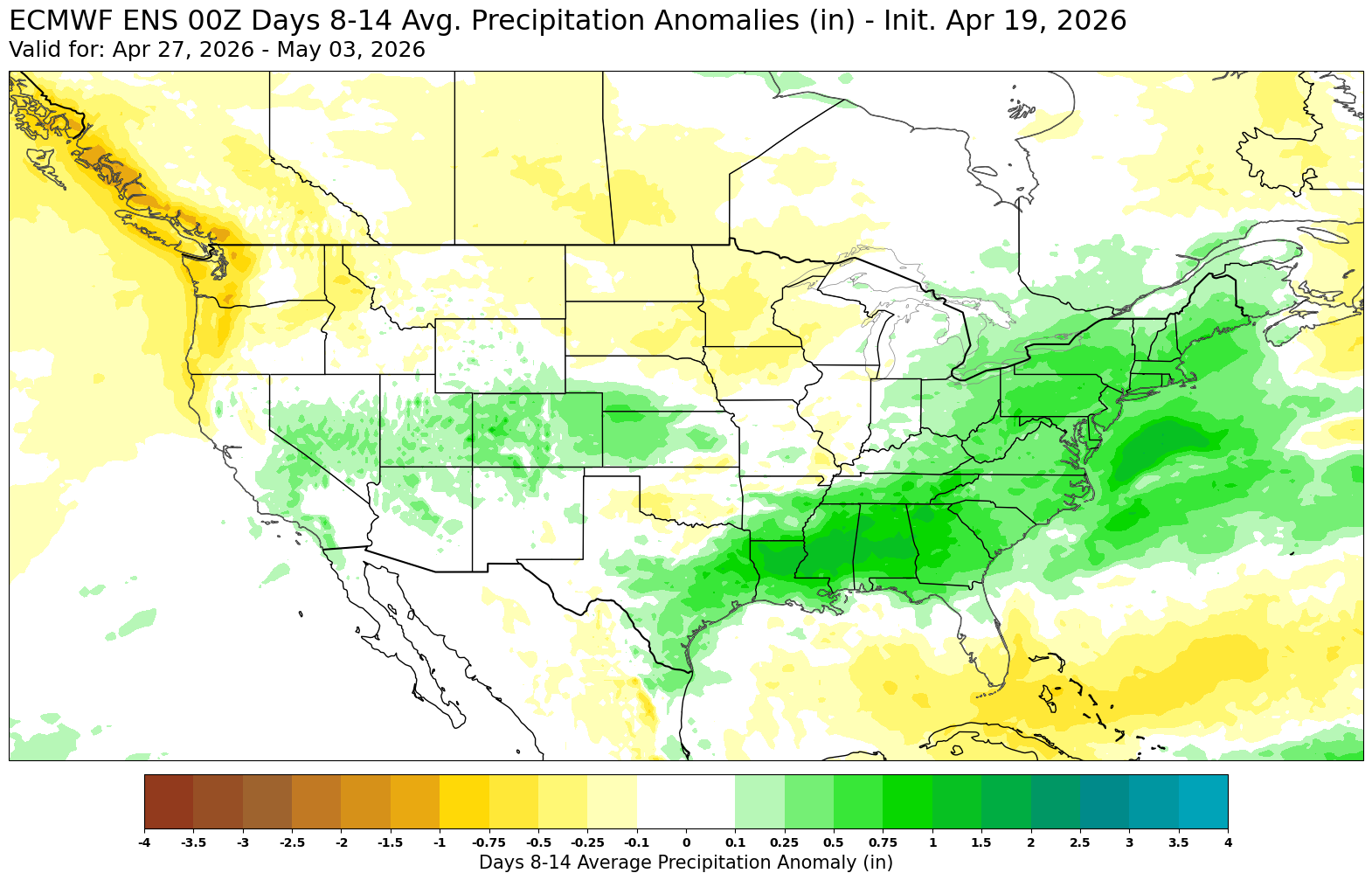
Yeah, would be nice for some improvement of the lower soil moisture to get at least one major storm system while the blocking and STJ is in place.

-

2026-2027 El Nino
bluewave replied to Stormchaserchuck1's topic in Weather Forecasting and Discussion
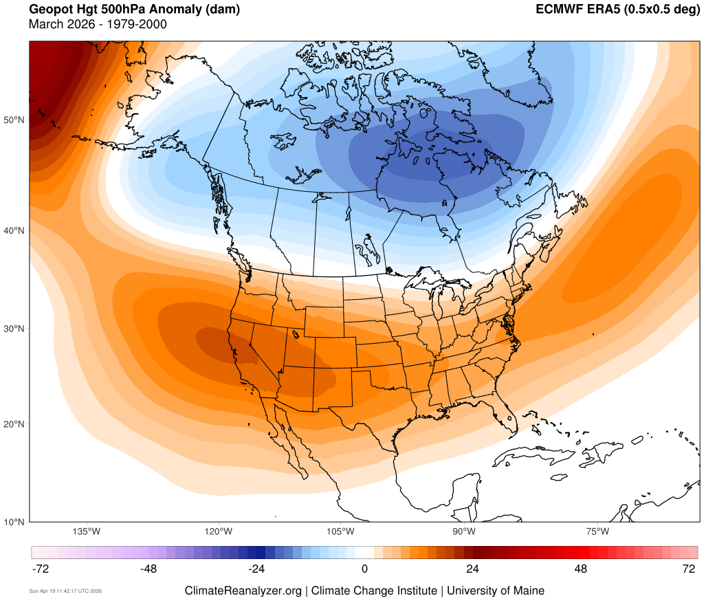
I try not to get too far ahead of things and just say at this point the temperatures next winter will probably be warmer than last winter was in the Northeast. Just hoping we can keep some semblance of a benchmark track going especially as we approach late January and February. I wouldn’t mind a mild winter at all if we could get a least one nice backloaded style event. The difference between 2015-2016 and 2023-2024 was that we got a great blocking pattern one winter and not so great the other winter. Even 2023-2024 had a good one week period in February with 2 events. But they were narrowly focused into portions of NJ and SNE really couldn’t cash in as much. We did get that record STJ in February associated with the larger event. Obviously, we would want to avoid a 97-98 outcome where we really didn’t get much snow at all. Unfortunately, we just don’t have the technology to forecast snowfall and blocking so many months in advance. Climate Reanalyzer has the 500mb reanalysis maps. But they are delayed a bit to around the 8th of the following month. https://climatereanalyzer.org
-
Seed and fertilizer down. Bring on the rain
-
https://www.jdjweatherconsulting.com/mar-13-15-2023
-
I’m pretty sure my downstairs zone will be on at least one morning in the next couple of days. 50 out there now with .18” thru the tipper so far.
-
Looks like some frozen precip is working into the west side of the Catskills. I don't want to turn the heat back on...
-

2026-2027 El Nino
snowman19 replied to Stormchaserchuck1's topic in Weather Forecasting and Discussion
Evidence of anomalous westerlies and an El Niño standing wave setting up…. -
42.8° with showers