All Activity
- Past hour
-

2026-2027 Record-breaking El Nino
rclab replied to Stormchaserchuck1's topic in Weather Forecasting and Discussion
The prophecy ……… self fulfilled ………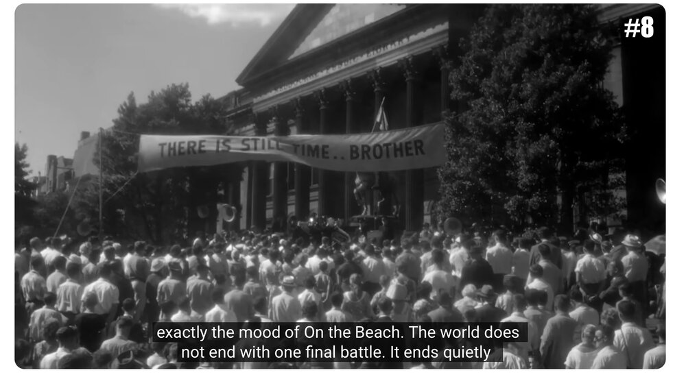
-
A sudden change of plans yesterday evening saw me driving up late last night as opposed to first thing this morning. I did not know about the storms coming until I hit I-70 around 9PM. I only wish I had a dash camera to capture the wind and lightning I drove through - I sort of timed it perfectly to get the peak action between Sideling Hill and Big Savage. Wasn't exactly the smartest night to be driving a 40 year old pickup across the Alleghanies, but I live to tell the tale. Looking forward to having the windows open Sunday and Monday.
-
Was just going to post about that too. The other *possibility* is if the bowing line segment approaching Stephens City can surge a bit more east versus south east - it wouldn't take much trajectory change to get at least the southern half of MoCo in on the show.
- 2,550 replies
-
- 2
-

-
- severe
- thunderstorms
- (and 7 more)
-

Monday, August 31 - Thursday, September 3, 2026 Convective Episodes
MJOatleast7 replied to weatherwiz's topic in New England
Reminds me of Catatumbo lightning over Lake Maracaibo, Venezuela. There they have up to one discharge every few seconds...ALL NIGHT LONG, every night, for several months. -

2026 Mid-Atlantic Severe Storm General Discussion
Eskimo Joe replied to Kmlwx's topic in Mid Atlantic
Well said. I agree with layering the Maryland counties adjacent to the Potomac River on the watch in case upscale growth occurs, but it's going to be tough. Our only chance seems to be from those storm just NW of Martinsburg getting their act together. -
0.23” last night loud thunder but heavy stuff missed west
-

Septorcher 2026 Discussion - Endless Summer
ineedsnow replied to Damage In Tolland's topic in New England
we pray for this!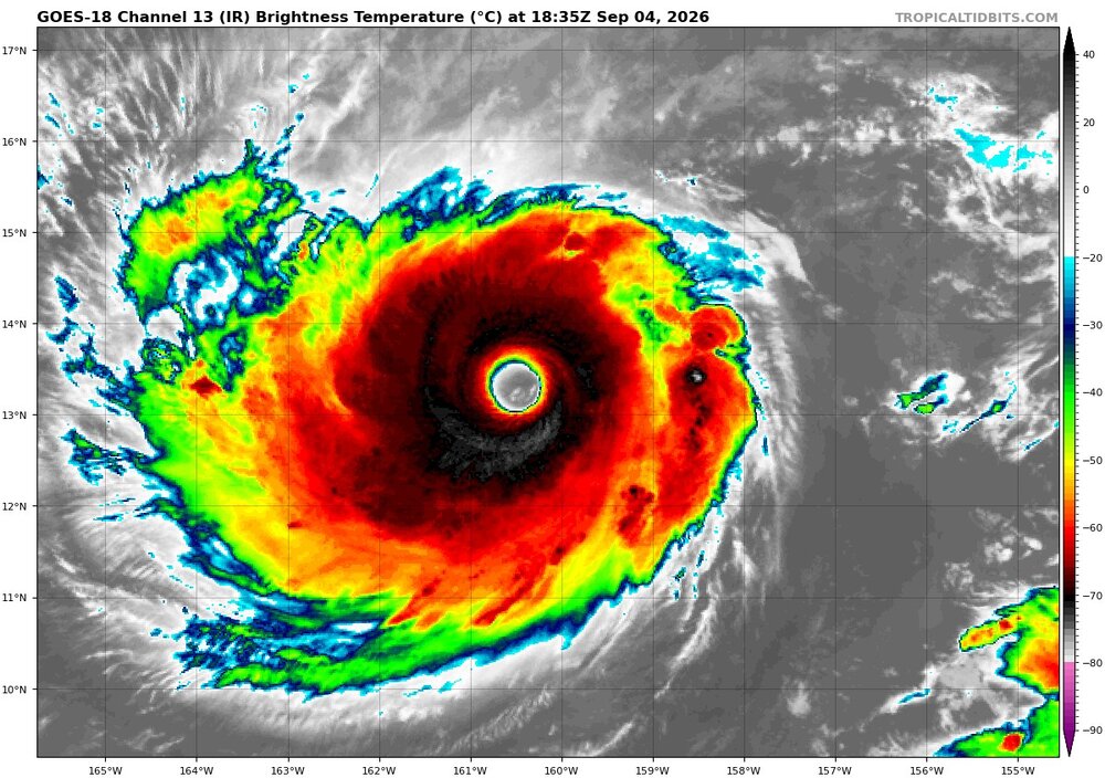
-
Stephens City special incoming
-
Septorcher 2026 Discussion - Endless Summer
ineedsnow replied to Damage In Tolland's topic in New England
hopefully the stronger it gets the more it feels the tug.. If I was there and it missed I would be pist -
Septorcher 2026 Discussion - Endless Summer
78Blizzard replied to Damage In Tolland's topic in New England
The long range on the Euro and the GFS couldn't be more different. -
Late to the party, but I got absolutely crushed in the Lowlands around 1215-1230 last night. Woke me up out of my sleep. Thunder shaking the house and torrential rain. I managed to go back to sleep, thankfully, but that was a crazy little stretch when it came through. Reminded me of nocturnal storms in the Mississippi Valley.
-
It was nice and sunny and then suddenly black! I missed the storm last night but saw a lot of lightning on my camera. Supposedly this front finally pushes through tomorrow?
-
 legal online pharmacy: overseas online pharmacy - legal online pharmacies in the us
 -

2026-2027 Record-breaking El Nino
Typhoon Tip replied to Stormchaserchuck1's topic in Weather Forecasting and Discussion
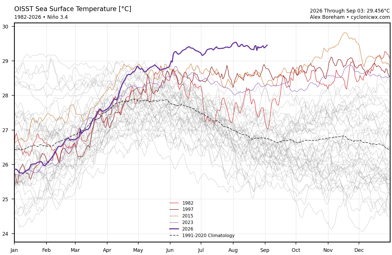
It's interesting that while this is observably weighted E ... the 3.4 is historically high. -

2026-2027 Record-breaking El Nino
mitchnick replied to Stormchaserchuck1's topic in Weather Forecasting and Discussion
So that is your best, name calling....ok -

2026-2027 Record-breaking El Nino
forkyfork replied to Stormchaserchuck1's topic in Weather Forecasting and Discussion
what else am i going to do? take you seriously? lol -
canada pharmacy 24h or reputable canadian online pharmacies 77 canadian pharmacy http://prosports-shop.com/shop/display_cart?return_url=http://mapplemed.com pharmstore canada and http://clubdetenisalbatera.es/user/jkkbsconbj/ thecanadianpharmacy [url=http://maps.google.com.na/url?q=https://mapplemed.com]canadian pharmacy 24h com[/url] canadian drug and [url=https://armandohart.com/user/kzvotuurmd/?um_action=edit]canadian pharmacy mall[/url] canadian pharmacy mall
-
canada pharmacy 24h or reputable canadian online pharmacies 77 canadian pharmacy http://prosports-shop.com/shop/display_cart?return_url=http://mapplemed.com pharmstore canada and http://clubdetenisalbatera.es/user/jkkbsconbj/ thecanadianpharmacy [url=http://maps.google.com.na/url?q=https://mapplemed.com]canadian pharmacy 24h com[/url] canadian drug and [url=https://armandohart.com/user/kzvotuurmd/?um_action=edit]canadian pharmacy mall[/url] canadian pharmacy mall
-
My PWS recorded .35", but given that it fell in :10, and was falling sideways most of that time, maybe more?
-
Time for the daily monsoon rains in the Western Maryland mountains. Feels more like Florida. We don't seem to get normal rain anymore. Its blow out the gullies and wash away all that mulch and top soil from your new landscaping type rains. Even put in rip rap and culverts but those get overwhelmed.
-

2026-2027 Record-breaking El Nino
LakePaste25 replied to Stormchaserchuck1's topic in Weather Forecasting and Discussion
I’m sorry but this is just incorrect to say it’s not the warmest. You should specify that it’s not the highest relative Nino 3.4 index. To flat out say “it’s not the warmest” is incorrect. If my local airport reaches 101, that would be the warmest temperature on record, since the all-time record is 100. If i come up with some “relative temperature” it doesn’t change that fact. The fact still stands that Nino 3.4 is at its all time highest, and has been consistently.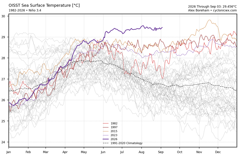
-

2026 C and E Pacific tropical activity
WxWatcher007 replied to GaWx's topic in Tropical Headquarters
- Today
-
Septorcher 2026 Discussion - Endless Summer
WxWatcher007 replied to Damage In Tolland's topic in New England
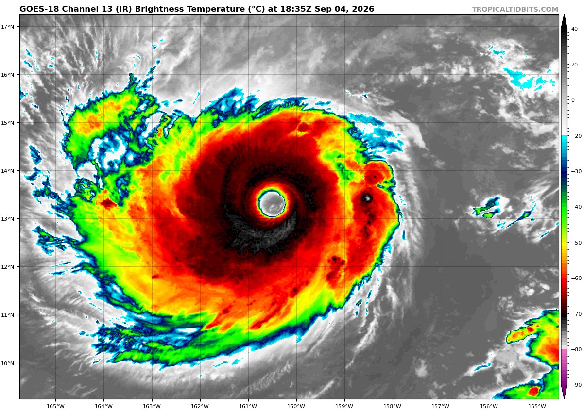
What a year in Hawaii -

E PA/NJ/DE Autumn 2026 Obs/Discussion
BBasile replied to PhiEaglesfan712's topic in Philadelphia Region
Picked up 0.22' of rain this morning. So, 2.04" on the month and 18.69" since July 1. -

2026-2027 Record-breaking El Nino
bluewave replied to Stormchaserchuck1's topic in Weather Forecasting and Discussion
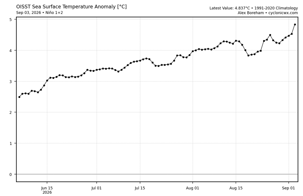
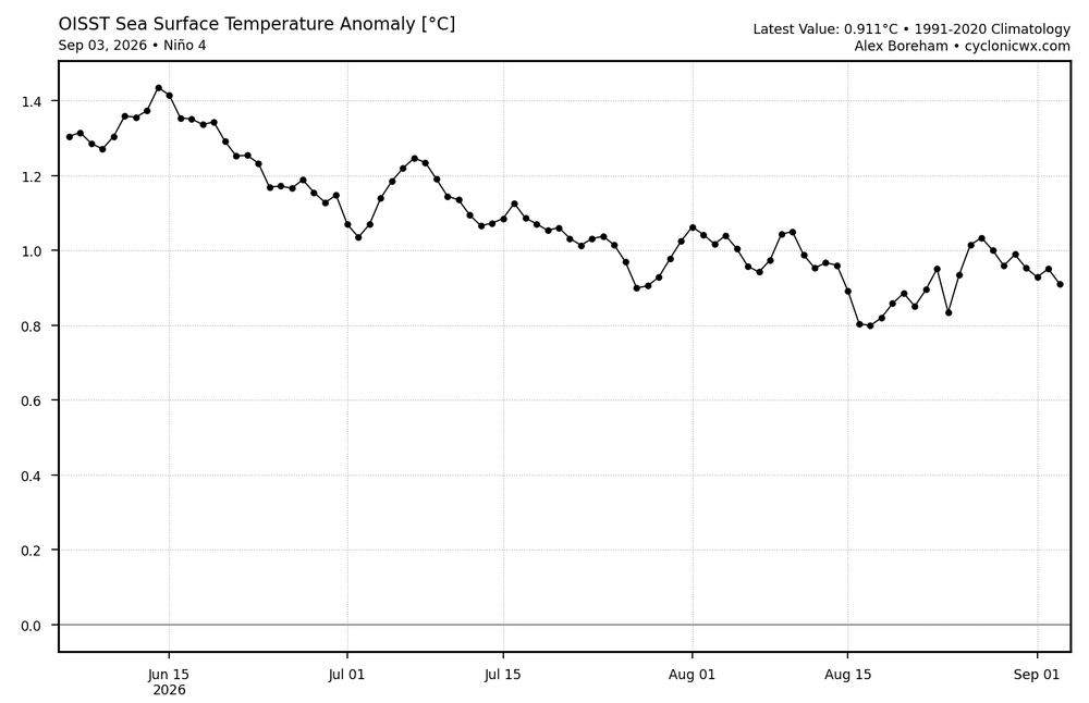
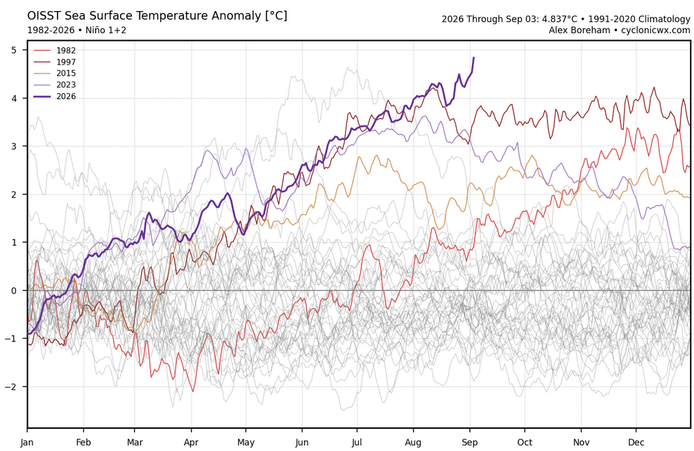
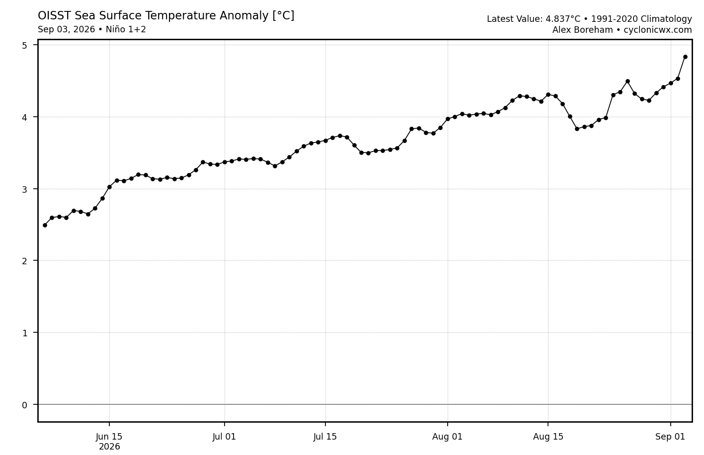
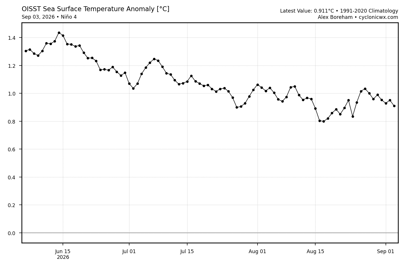
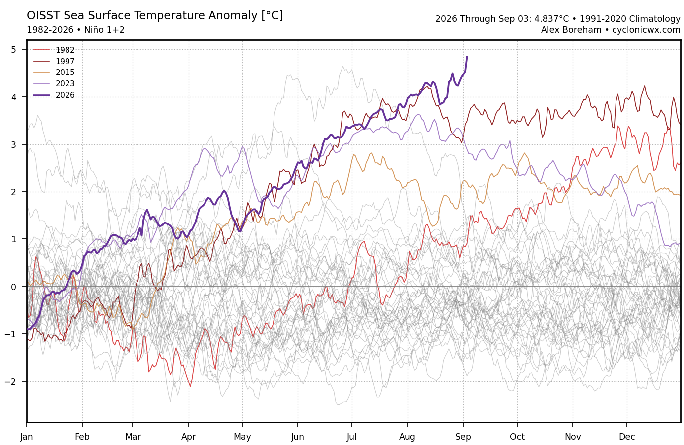
Models really missed how east based an event this has become. Not that big of a surprise since they can’t really can’t forecast the WWBs with that much precision beyond a week or two. This is the reason that Nino 3.4 leveled off in August and Nino 4 declined. It has resulted in the highest Nino 1+2 daily anomaly on record and it’s only early September.