All Activity
- Past hour
-
 No worrying about track, banding, or ratios. Just large scale WAA up thy fanny.
 -

Central PA Summer 2026 Discussion/Obs Thread
Voyager replied to Voyager's topic in Upstate New York/Pennsylvania
I might have to go into the witness protection program after posting this...
-
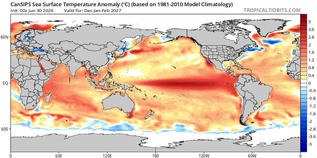
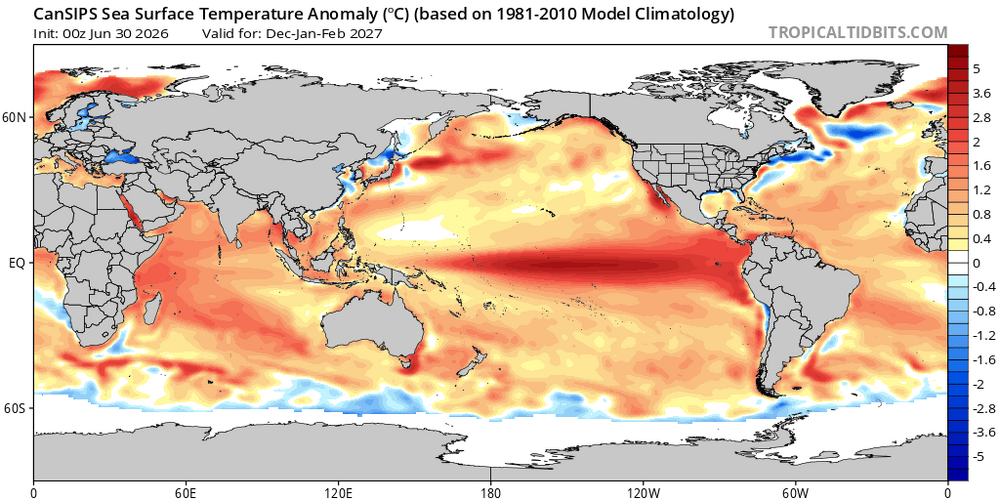
CanSIPS has a basin wide Nino for the winter months. If that verifies the chances for snow vs mostly rain will largely be determined by the HL pattern. As currently advertised the h5 look(+PNA/-EPO/ possibly -AO/NAO should bring some colder air southward at times to combine with a pronounced STJ and some favorable storm tracks. All speculation at this juncture ofc. I will 100% roll with that idea. Anything but a strong East-based event.
-
98 75dp 112 hi in sunny SE. A cracking 101 on my porch in the shade
-
95/106
-
 Simply magical weather . It truly is
 -

E PA/NJ/DE Summer 2026 Obs/Discussion
MGorse replied to PhiEaglesfan712's topic in Philadelphia Region
It is rather toasty out! Heat index here is 108F! -
One record to watch for RDU (and likely other sites) is the record for longest consecutive streak of 100+ degree highs. Current record from 2012 is 6 days. NWS is forecasting 5 straight 100+ days at the moment (100, 102, 102, 103, 100) but Tuesdays high will be dang close at 98 (and we know 2 degrees above forecast is just a casual Tuesday for the RDU sensor).
-
Alot of local stations at 100 near me. Frank, what are you at? I know you are in Aruba but still lurking.
-
What a scorcher right now. A lot of places may not drop below 80F tonight and tomorrow night.
-
Make that 100 on the dot at my PWS.
-
 BDL 95/74. Nice late day push and impressive dews.
 -
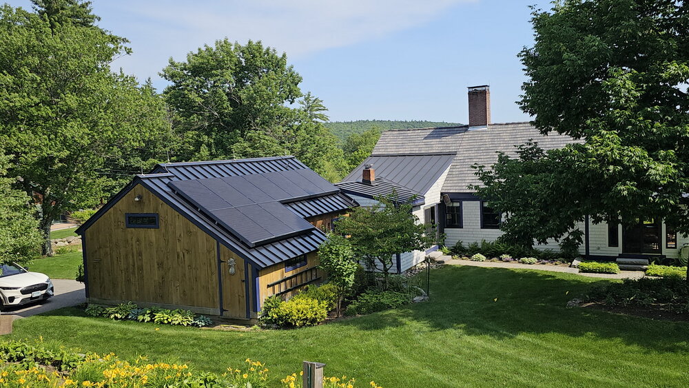
 We have a standing seam newer metal roof. The panels are clamped on the standing seams. 2 years, no problems. Just panels east/west on the barn. Today I'm running 3 window ACs and charging my 4 year old Mustang Mache and the system is generating more power than I can use. I'm sending the extra back to the grid and getting paid for that about $3 so far today. Other people might have problems but going with my electric car and roof has been a huge W for us. (Picture taken around 3:30pm). Golden Retriever approved! 4pm 92/74F
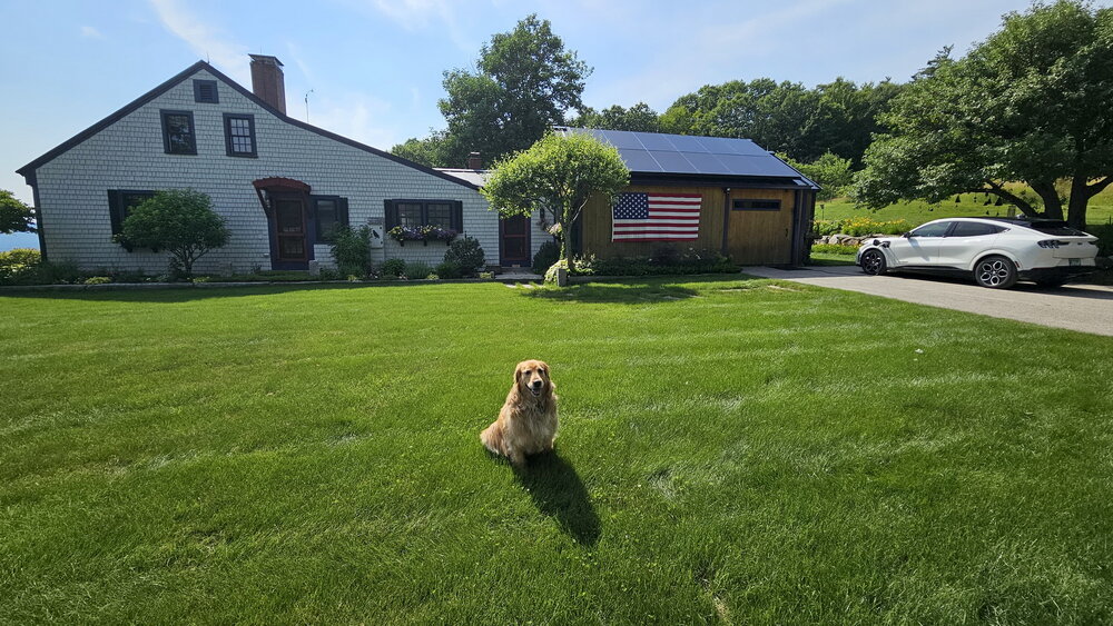
-
 late was busy with graduations and parties DCA: +2.5 NYC: +3.0 BOS: +3.2 ORD: +2.8 ATL: +2.1 IAH: +1.8 DEN: +2.7 PHX: +1.6 SEA: +1.6
 -
Wonder if we sneakily hit our max heat index today. I'd trade in the 70+ dps to make a run at a all-timer on Friday though.
-
 Lease agreements require new home owners to accept the original terms of the lease. I wouldn't agree to that, either. one of the big reasons why you want to own the panels and not lease them
 -
Highest HI here was 106. Temp now 93 after a high of 95
-
They might've hit 100° today if they weren't river winded for so long.
-

2026-2027 Super El Nino
snowman19 replied to Stormchaserchuck1's topic in Weather Forecasting and Discussion
No coincidence that we saw the twin/triplet tropical cyclones back in April with this super El Niño. A whole parade of them are expected to form this month, keeping the WWBs/westerlies going in their wake as far as the eye can see…. -
91 dew 75. Temps is hot but not extreme. Been steady at about 91 since just after 12pm. Humidity is what tough. Heat index staying in the low 100s. Sometimes days like this will have a late day high in the evening. South wind fizzles and a quick spike occurs.
-
84 is the record right? Same is NYC. I think that year EWR had a low of 86 one of those nights lol. NYC had a 104/84 - I remember, lost the keys to my place out on a date. It was like in the mid 90s in the city at 2am as I was trying to get back into my building lol.
-
96/76 for the 4pm ob at DCA, HI of 110. Damn.
-
Yeah the chance that we'll see anything here today is very slim -- I'd say a 10% chance. But I am watching radar and praying, lol.
-
 Just dropped under 90F. Seeing some PWS on the harbor in Kittery now in the upper 70s.
 -
Any threat to low max records? That stretch from July 22-24, 2011 at DCA was nuts with 83 84 84