All Activity
- Past hour
-
Sun angle has nothing to do with cold with a cold pattern in place. Your predictions this winter have been outrageous .
-
I've been pushing more of a 'melt and mud' season for the time being. There's a higher ceiling than that. However, in deference to the fact that every month since last October has successfully target this region of the continent for disproportionate cold relative to the whole hemisphere, it's hard to imagine this warm up performing at the higher end - just based on that unmitigated persistence.
-

Central PA Winter 25/26 Discussion and Obs
canderson replied to MAG5035's topic in Upstate New York/Pennsylvania
Ice jam city - it’s wild how the leading edge is flat then it’s moon crater everywhere -
52 / 38 warmes since Jan 14th here.
-

Pittsburgh/Western PA WINTER ‘25/‘26
Rd9108 replied to Burghblizz's topic in Upstate New York/Pennsylvania
After today idk if I want it back. -
47F/ clouds
-

E PA/NJ/DE Winter 2025-26 Obs/Discussion
bringmesnow1 replied to LVblizzard's topic in Philadelphia Region
"A" graded winter IMBY. 12" snow and sleet from the big January storm, but could have been 18"+ if it stayed all snow. 12" for the blizzard but I wasn't here to see it, places to my East got 20"+ and the blizzard conditions didn't seem to materialize in northern Delaware. It's an A+ if we get 18+ from either of those storms. A bit picky I guess lol. -
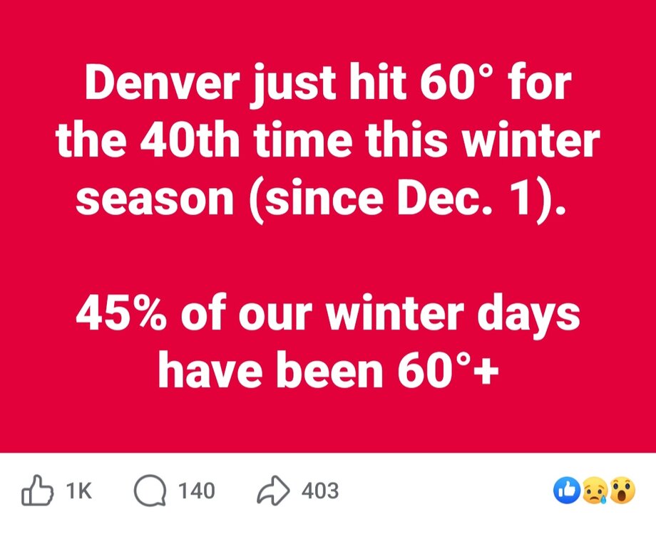
And after several a couple days of nice runs the GFS is back to zero snow for the front range out to 384.
-

Pittsburgh/Western PA WINTER ‘25/‘26
colonel717 replied to Burghblizz's topic in Upstate New York/Pennsylvania
Both the GFS and AIEuro like 12-15th to bring winter back. -
Honestly, don’t need warm I will gladly take 45-50F as a cool down
-
For this year, it's finished. The sun angle is going to prevent us from getting arctic cold. As for the next east coast snowstorm pattern, your guess is as good as mine. I can guarantee you, though, that there probably won't be one until at least November.
-
That's like a 'rubber band' pattern at the end of that GFS. Basically ... the model loses the forcing that driving the predominating signal, earlier in the run's time spans, and there's a kind of emergent 'elasticity' where the physics respond by then default to huge instability ... creating a pattern overcompensation. That's likely all manufactured by normal accumulation of a randomness over time finally buckling the scaffold of the total synopsis and then that emerges, equally as a result of randomness. In other words, there's pretty much 0 practical usefulness of that storm/chart. Having said that...yeah, in principle, the warm pattern is not likely to last indefinitely ... even though I want it to. HAHAHA. Personal druthers aside, I wouldn't be shocked if the warm pattern begins to progress off and the emergence of a western limb -NAO burst happens. It's in the latter sequence of events that here may be a last hurrah winter expression ...be it temperatures and annoyance or perhaps an actual event. Boinnnng or not, the GFS also looks like what it does every year's first 2nd or third warm up - I know...because I whine about it ...every year at this time. It washes out warm signal prematurely and then resets the basal pattern back to Feb 1. Not sure why it predictably does this, but that pattern at the end of the run with those long wave spaces and deep heights over Canada strikes me as suspiciously the same thing it does ever early to mid spring.
-
Great day for a walk. Centennial lake in HoCo still 80%+ iced over
-
Feels really nice. Wind kicking up though.
-
It will happen at the eleventh hour, if it does.
-
Torch AWT! 53 .. Grass showing up in spots feels like 70 out in the sun
-
I like comparing that 30 year period to now as 1970/71 followed the epic snowfall stretch of 1955 to 1969 just like we have recently exited the recent epic stretch.
-

-
-
50
-
Going to take the newborn out next month when it gets warmer.
-
Beautiful spring day. Good day to shovel out the garage.
-
That is WOR revenge storm, too bad it in 360+ hrs out.....
-
 DCA _ NYC _ BOS _ ORD _ ATL _ IAH _ DEN _ PHX _ SEA +2.8 +2.7 +2.1 +2.8 +3.1 +1.9 +1.8 +2.1 +0.5
 -

Winter 2025-26 Medium/Long Range Discussion
michsnowfreak replied to michsnowfreak's topic in Lakes/Ohio Valley
Youre in the majority on that train of thought....but it still doesn't mean its not going to happen lol.


