All Activity
- Past hour
-

The “I bring the mojo” Jan 30-Feb 1 potential winter storm
Buddy1987 replied to lilj4425's topic in Southeastern States
-

The Jan 31 Potential: Stormtracker Failure or 'Tracker Trouncing
bncho replied to stormtracker's topic in Mid Atlantic
We need that ULL to trend north. Normally it wouldn't matter too much as a low that strong would jump climb up the coast but that kicker kinda hurts our chances of that. -

Central PA Winter 25/26 Discussion and Obs
canderson replied to MAG5035's topic in Upstate New York/Pennsylvania
It’s remarkable out in the city, isn’t it? -

Possible coastal storm centered on Feb 1 2026.
Ginx snewx replied to Typhoon Tip's topic in New England
Thanks man -

January 2026 Short/Medium Range Thread
Weatheriscool replied to John1122's topic in Tennessee Valley
Day four no power. I always do face book live while driving and have been last few days. If anyone wants to see what is going on here, send me a friend request Matthew Rosenboom and a message here so will know who you are -

The Jan 31 Potential: Stormtracker Failure or 'Tracker Trouncing
Maestrobjwa replied to stormtracker's topic in Mid Atlantic
Nah it's not just you, lol I struggle with these maps as well -

The Jan 31 Potential: Stormtracker Failure or 'Tracker Trouncing
Lucy Pull replied to stormtracker's topic in Mid Atlantic
trend GIF from tidbits can be helpful for run to run trends.
-
I went from Nothing in Morris County to a blizzard. I ended up with like 24” or so. 50 miles to my West had less than 6”.
-
(002).thumb.png.6e3d9d46bca5fe41aab7a74871dd8af8.png)
E PA/NJ/DE Winter 2025-26 Obs/Discussion
ChescoWx replied to LVblizzard's topic in Philadelphia Region
I put the link above there are some NWS spots around that area - I grew up in NE Philly so check out: Neshaminy Falls 1915-Present - 24.5" of snow so far this season George School 1906-1978 Southhampton 1979-2013 -

The Jan 31 Potential: Stormtracker Failure or 'Tracker Trouncing
Chris78 replied to stormtracker's topic in Mid Atlantic
The thing that gives me a little hope is how far west the snow extends. The low cutting off further north is very believable in my opinion. It's a different set up but last weekend we bled north seemingly every model run the last 2 days. I'm further west than you and need more of a trend but I don't think anyone south of the M/D line is out yet. We need to start seeing a positive trend today though imo. -
Looks like a pick’em on ending winter next week
-
Such a tight gradient on all the eps members etc because of how wound up the system is. I feel like we’d need a pretty large shift for this range to get the city in the goods, but I still think we can muster few inches if we get lucky
-
It wasnt even 48 hours out. Xmas day the totals when from 6-12 to 12-20. No one was ready for that and the disaster that unfolded in the city was the result of that
-

The “I bring the mojo” Jan 30-Feb 1 potential winter storm
BornAgain13 replied to lilj4425's topic in Southeastern States
U know its on like donkey Kong when u have 74 people in this forum at 9:13 am -
Hi-Res Nam gets a few hours of light snow for some this evening .
-

The Jan 31 Potential: Stormtracker Failure or 'Tracker Trouncing
BristowWx replied to stormtracker's topic in Mid Atlantic
Can someone circle those higher heights? I just cannot see the difference but I am a tool. Thanks -
The “I bring the mojo” Jan 30-Feb 1 potential winter storm
Buddy1987 replied to lilj4425's topic in Southeastern States
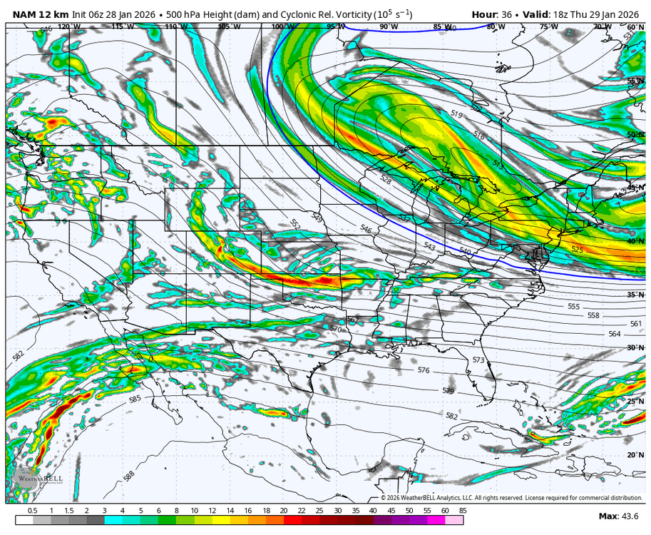
Nam trying to take the trough and turn it neutral at 34. Not sure which way this is going yet. Some positives though up top with the large lobe above Superior. -

The “I bring the mojo” Jan 30-Feb 1 potential winter storm
SUNYGRAD replied to lilj4425's topic in Southeastern States
Not sure, but my brain went immediately to the Land of The Lost for some reason. -
At work now… should I expect or know when I could count on any hot weenie action out yonder this weekend, or will it just be cloudy and cold? [emoji3063] .
-
The top 5 analogs over the East at 96hrs from CIPS. Some all time greats. 1) 1/23/16 2) 12/26/10 3) 1/8/96 4) 3/3/2010 - Massive rain and wind storm 5) 2/24/89
-

Winter 2025/26 Banter Thread
SchaumburgStormer replied to Chicago Storm's topic in Lakes/Ohio Valley
Wake up, check gfs out to 384hrs, less than 2" of snow progged for MBY. Close browser, sigh loudly, get angry at myself for believing after our hot start. -

The “I bring the mojo” Jan 30-Feb 1 potential winter storm
NorthHillsWx replied to lilj4425's topic in Southeastern States
This feels like uncharted territory for most of us given the last 7-8 years -
Yeah also thinking the 500 mb pattern on the ensembles suggests more coast to coast cold as opposed to the west torching and the east way bn. Should be a fun period.
-

The Jan 31 Potential: Stormtracker Failure or 'Tracker Trouncing
osfan24 replied to stormtracker's topic in Mid Atlantic
Hopefully that map lifts as far north this time as it did last storm. it’s frustrating seeing the ensembles and seeing the lows seem mostly clustered west of the mean but it doesn’t seem to be making a difference yet. -

The Jan 31 Potential: Stormtracker Failure or 'Tracker Trouncing
Weather Will replied to stormtracker's topic in Mid Atlantic
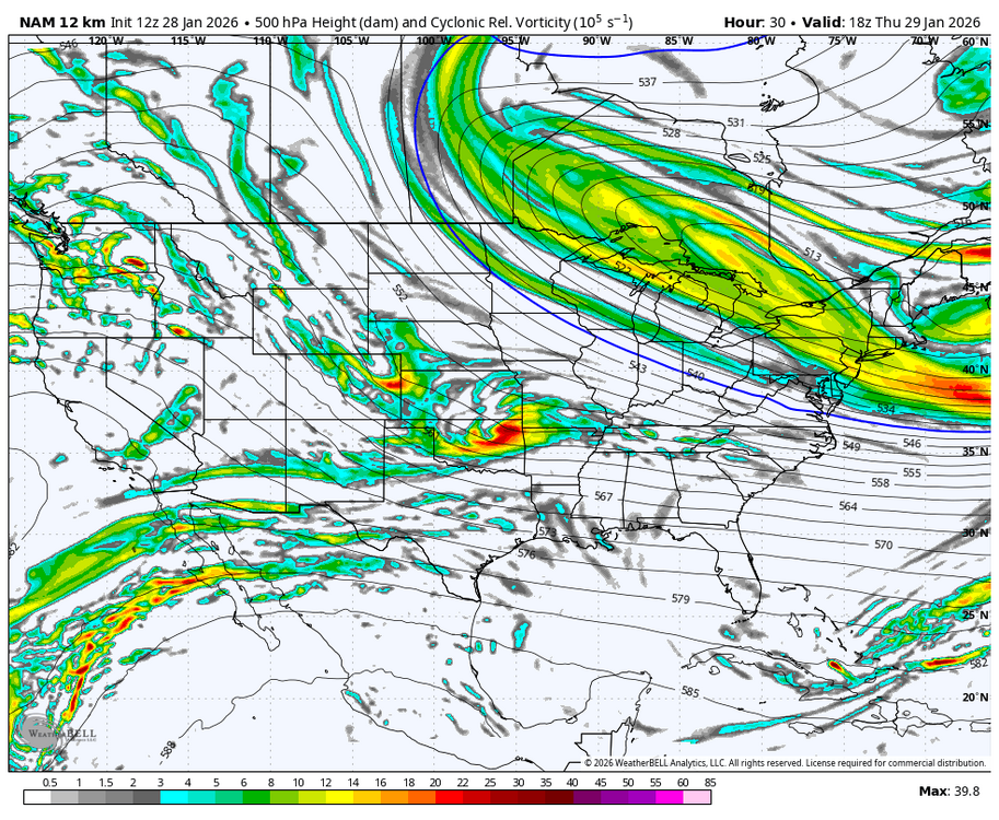
WB 12Z 12K NAM Hr. 30; heights higher in east compared to 6Z.