All Activity
- Past hour
-
Still waiting for your very warm post-Thanksgiving pattern to start showing up..
-
Kinda getting used to 30s. Guess it has to end sometime
-
Feels like Deep Winter (TM) in Silver Spring. Heavy overcast, 30 degrees, 7 degree dew point, sometimes a bit of wind. Cold!
-
2.5 very likely here as radar still has a way to go
-
Raleigh is going to zero out on accumulation unless there is an additional burst tonight.
-
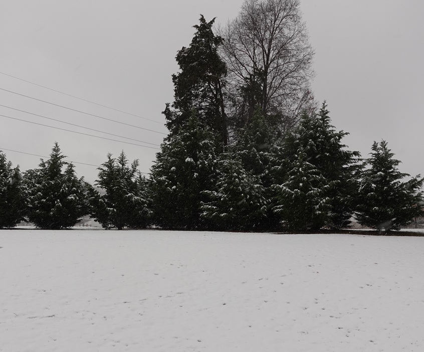
An additional 0.8" of snow accumulated since my last measurement of 1" at 1pm for a total of 1.8". It's still snowing lightly with occasional moderate bursts, so I might make it to 2" before all is said and done. 31.3°/31.0°
-
Wakefield has 5 inches already. Great event for many on the south side.
-
This sounds like my life right now. Add in working from home and it's chaos.
-
Upton is downplaying the late weekend system - maybe some light snow friday night
-
Still have alot of returns to the west. Though lighter, the sun setting will help. 1.75
-

The Monday wintry event potential (12/8/25)
olafminesaw replied to GaWx's topic in Southeastern States
Additional QPF. Raleigh may end up with half an inch or so this evening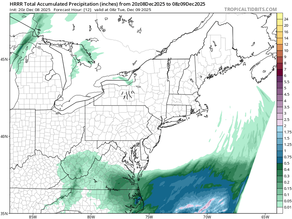
-

December 2025 regional war/obs/disco thread
moneypitmike replied to Torch Tiger's topic in New England
Nice. P/C has me at 1* tonight. Hoping to dip below--not sure how likely that is 15.3 now. -
32.3 here in Franklinton. Light snow right now. Has been off and on light snow. Got a dusting currently. WIll be interesting to see how long we can keep it going this evening.
-
Just the opposite
-
December 2025 regional war/obs/disco thread
moneypitmike replied to Torch Tiger's topic in New England
Sometimes they morph into none. -

December 2025 regional war/obs/disco thread
weatherwiz replied to Torch Tiger's topic in New England
I love the Winter Storm Watches that get hoisted in the midwestern states for 1-2" of snow with winds gusting 50-70 mph. That has to be epic -

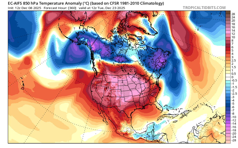
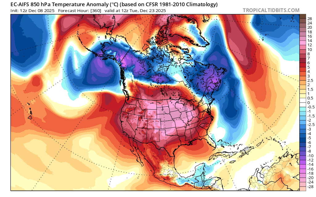
December 2025 Short/Medium Range Forecast Thread
Carvers Gap replied to John1122's topic in Tennessee Valley
I do think there will be a ridge which rolls through between the cold shot on the 14th and the next one on the 18th. That has been strongly modeled, Bastardi has noted the WPO has been erroneously modeled by the Euro/EPS suite for weeks. He thinks there is a problem with its algorithm. He noted the WPO appears to be driving the pattern. When it weakens, other drivers take over. -
Time to move south for snowier winters
-

Winter 2025-26 Short Range Discussion
WE GOT HIM replied to SchaumburgStormer's topic in Lakes/Ohio Valley
hi friend -

Winter 2025-26 Short Range Discussion
WestMichigan replied to SchaumburgStormer's topic in Lakes/Ohio Valley
All I need is a nudge and things are looking decent here. -

2025-2026 ENSO
Stormchaserchuck1 replied to 40/70 Benchmark's topic in Weather Forecasting and Discussion
I don't think a warm up will sustain. The Strat warming gives -NAO tendency the last week of Dec and 1st week of January, and I've mentioned this before, but we had some very low N. Hemisphere 500mb lows in the Summer and Fall. Since 2012, that has a really high correlation with following Winter -AO, primarily at 90N. A High pressure at 90N, which I'm going to say is this Winter's tendency, does cool the northern part of the US. On the other hand, the weak-negative-ENSO/strong -QBO matches that are working out really well (1989, 2005) did flip to a +EPO pattern in late Dec that lasted all of January. We are following those analogs closely right now, but I do think that 90N High pressure tendency may overcome the sustained warmth that those analogs saw going later into the Winter. It is interesting to see the long range models flip warm though, which happened in those years. -
Yeah, that makes sense actually. With the Kelvin wave already discussed constructively interfering with the MC region while it passes through. So a break in the pattern is plausible, potentially. Not set in stone. But I could see that happening. Interesting about the base state favoring -wpo and -nao episodes. Seems any break in the cold wouldn't be long lived under these circumstances. Really interesting year we have here.
-
December 2025 Short/Medium Range Forecast Thread
Carvers Gap replied to John1122's topic in Tennessee Valley
I just don’t see the evidence of it being in 6. There is no ridge in the east at the moment. Only the EPS is modeling a big warm up. It could happen. There were some overnight runs which support that. But the EPS has struggled mightily. All of these warmup have yet to verify. I think after the 20th seems right. -
https://x.com/ryanmaue/status/1998119023360577944?s=46&t=m4Eqkekadb-JCXTm7k-Txg
-

December 2025 regional war/obs/disco thread
RUNNAWAYICEBERG replied to Torch Tiger's topic in New England
Ain’t no stopping this either…