All Activity
- Past hour
-
Anyone who thinks they have a handle on the longer range - should think twice before coming to any conclusions
-

January 2026 regional war/obs/disco thread
Sey-Mour Snow replied to Baroclinic Zone's topic in New England
What’s hard to understand? -
January 2026 regional war/obs/disco thread
Sey-Mour Snow replied to Baroclinic Zone's topic in New England
Wasn’t going on a limb there.. A west based monster block was modeled for days. What’s your forecast just hiding behind your computer and calling out others? Or do you have one? -
AI analyzing AI AIception
-

January 2026 Short/Medium Range Thread
Weatheriscool replied to John1122's topic in Tennessee Valley
That was one cold and dry run for sure -
Picked up another fluffy 2" last night and this morning.
-

January 2026 regional war/obs/disco thread
George001 replied to Baroclinic Zone's topic in New England
I disagree with this, its more of a motivation than a capacity thing. -
What did the models miss earlier this week that has degraded our good look for next week?
-
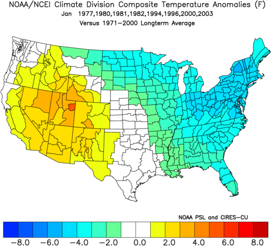
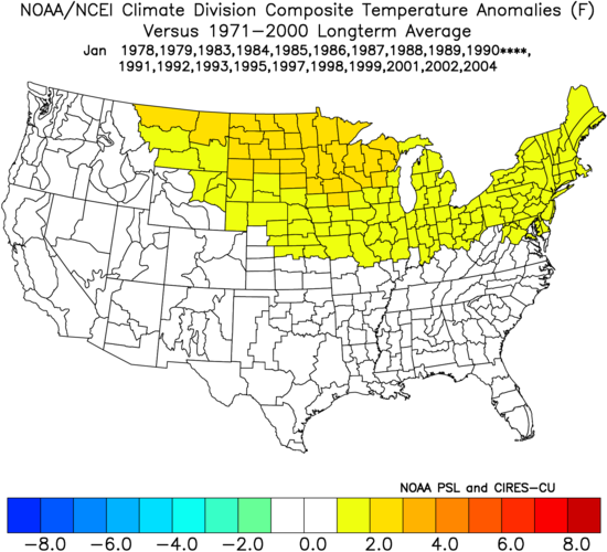
The model consensus is suggesting a good chance for the Jan MJO to stay inside the circle for 20+ days. Only the following Jans were inside the circle for 20+ days (note that it’s been 23 years since the last one due to the MJO avg amp increasing): 1977, 1980, 1981, 1982, 1994, 1996, 2000, 2003 Of these 8 Jans in the E US, 1977, 1981, 1982, 1994, and 2003 were cold while 1996 and 2000 were NN to slightly BN. Only 1980 was AN and it was only modestly AN. So, none were anywhere near a torch. Here’s the cold composite for these 8 Jans with 20+ days on or inside the circle: Here’s the composite for the other Jans near the endpoints and in between: MJO outside circle 12+ days
-
I can't forsee what will happen in 2 weeks, but I am optimistic based on the relatively cold and active pattern that we are presently experiencing. Of course, the ugly Pacific jet just doesn't quit...
-

January 2026 regional war/obs/disco thread
40/70 Benchmark replied to Baroclinic Zone's topic in New England
Get me a real storm I'll concern myself with thermals.....I'm done with the days of 20s and useless clippers. That's okay if you already have a deep pack... -
Gfs suite has been adamant with bringing the cold back just before the 15th and was not as bullish on the period before/around the 10th as the Euro suite was. Frankly, as screwed up as the Euro suite has performed, I'm more inclined to go with the Gfs as crazy as it sounds. The Geps, at the end of its 0z run, was closer to the Gfs with well BN temps moving through the Midwest our way.
-

Central PA Winter 25/26 Discussion and Obs
mahantango#1 replied to MAG5035's topic in Upstate New York/Pennsylvania
Looks like I'll close out the year 2025 with 39.55in of rainfall. So we'll carry over the current drought to the new year. Maybe it will be a little wetter next year, and we can put drought behind us. -
January 2026 regional war/obs/disco thread
40/70 Benchmark replied to Baroclinic Zone's topic in New England
Yea, I'm ready to risk winter and get on with it. -
Going to need Nina to end then maybe we can get some precipitation
-

January 2026 regional war/obs/disco thread
Snowcrazed71 replied to Baroclinic Zone's topic in New England
Well that bodes well for you. If you're away on vacation somewhere warm. You're not going to be missing much. Might as well do it now so you can come back to hopefully some good stuff. Enjoy -
The monthly departures at GRR are fairly significant at -4.3°F so far. Here is a monthly chart that would make even @beavis1729 happy. It has sure been a cold month in Fairbanks. They are averaging about 17.6°F below normal for the month.
-
We have seen this before as well. The - NAO linking with the WAR, likely due to the SE ridge/WAR becoming more prominent due to the reaction from the Pac jet extension.
-

January 2026 regional war/obs/disco thread
mahk_webstah replied to Baroclinic Zone's topic in New England
he said 2 days ago the 10 day would be dogs hit pattern -
Yup, and we can talk about cold patterns two weeks off but unless the overall, large scale pattern shifts then that just means it's cold and dry. Which I guess some people like, I don't care I just want the drought to end.
-

January 2026 regional war/obs/disco thread
qg_omega replied to Baroclinic Zone's topic in New England
what????? -
One of my favorite winters. We need to have a few bigger snowfalls thrown in away from the mountains to have it truly match up. In other news, looks like MPV is on pace for a -5° December. Even though I would like a deeper snow pack, the ground has been pretty much covered since mid November. We melted out during the torch a couple of Friday's ago but it was covered back up later that even with a light dusting.
-
Every winter even the great ones take breaks. But the good December Ninas usually have a Part II in Feb or even Mar. The Part II often involved blocking that slowed down the Pacific and allowed one or two KUs. This winter has not been favorable for KUs yet because it's been northern stream dominated with the same fast Pacific flow, we were just able to capitalize on luck for once with smaller clipper type systems to get us above average for snow with the cold. 2020 had a huge Dec coastal storm, Jan 2018 had the huge coastal storm, Dec 2000 etc. We'll have to see if this can be a winter where we have a good Feb-Mar without having a major Dec coastal storm.
-

New Years Day 2026 - 1st snows of the new year possible
Damage In Tolland replied to Baroclinic Zone's topic in New England
Enjoy the ice pack till Morch there -
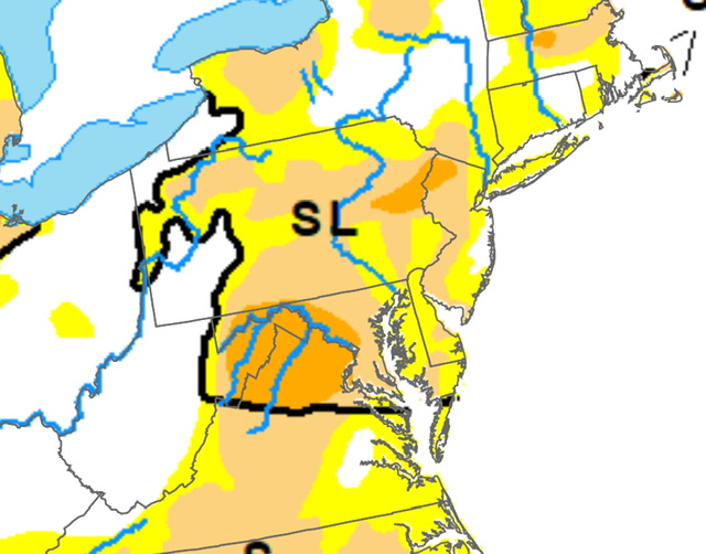
It knows where the drought is