All Activity
- Past hour
-
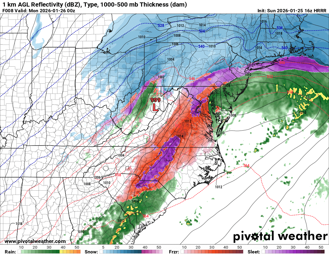
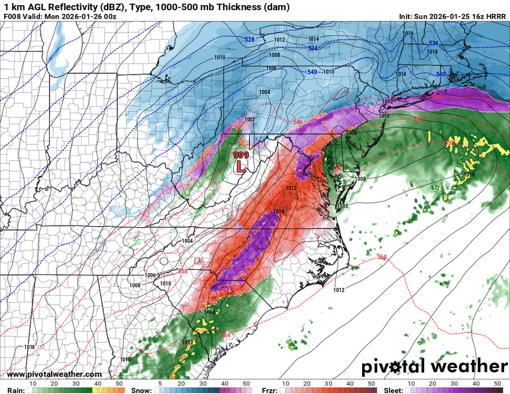
the hrrr is already too south with the sleet line by an hour
-

Southern Crippler - Get well soon Jimbo Storm Obs
NorthHillsWx replied to BooneWX's topic in Southeastern States
If we get a heavy thunder sleet band this storm won’t be a bust lol -

2025-2026 Fall/Winter Mountain Thread
Rainforrest replied to Buckethead's topic in Southeastern States
Our power just went out. -
PHL still mod/heavy snow with 0.5 mile vis at 12PM
-

Central PA Winter 25/26 Discussion and Obs
Jonesy56 replied to MAG5035's topic in Upstate New York/Pennsylvania
. -

Southern Crippler - Get well soon Jimbo Storm Obs
KrummWx replied to BooneWX's topic in Southeastern States
Oof. The Raleigh-Cary metro population is 1.5M and the Durham-Chapel-Hill population is 610k. Combined we get 2.1M and it's still smaller in land area than CLT metro by OMB. And everyone knows the 2 metros connect seamlessly. There are parts of Raleigh that are closer to downtown Durham than they are downtown Raleigh and vice versa. Shared suburbs and employment centers (RTP). When you combine Raleigh, Durham and Cary's (all border each other) population you get 988,000 people over only 318 square miles (1,020,000 at 326 if you add Morrisville) vs Charlotte at 945k with 308 square miles. The CLT MSA and CSA are insanely huge, so it's easy to artificially inflate your population numbers. Lastly, the Triangle is a tech-heavy metro, lots of compsci and lifesci dorks. That will auto-lend itself to more weatherdorks as science people usually enjoy other sciences. Charlotte is just generic banks, insurance, investments, etc. -
 The music man.
 -
They had heavy sleet in Arkansas last night at 3 degrees
-

1/24-1/25 Major Winter Storm - S. IL, IN, and OH
michsnowfreak replied to A-L-E-K's topic in Lakes/Ohio Valley
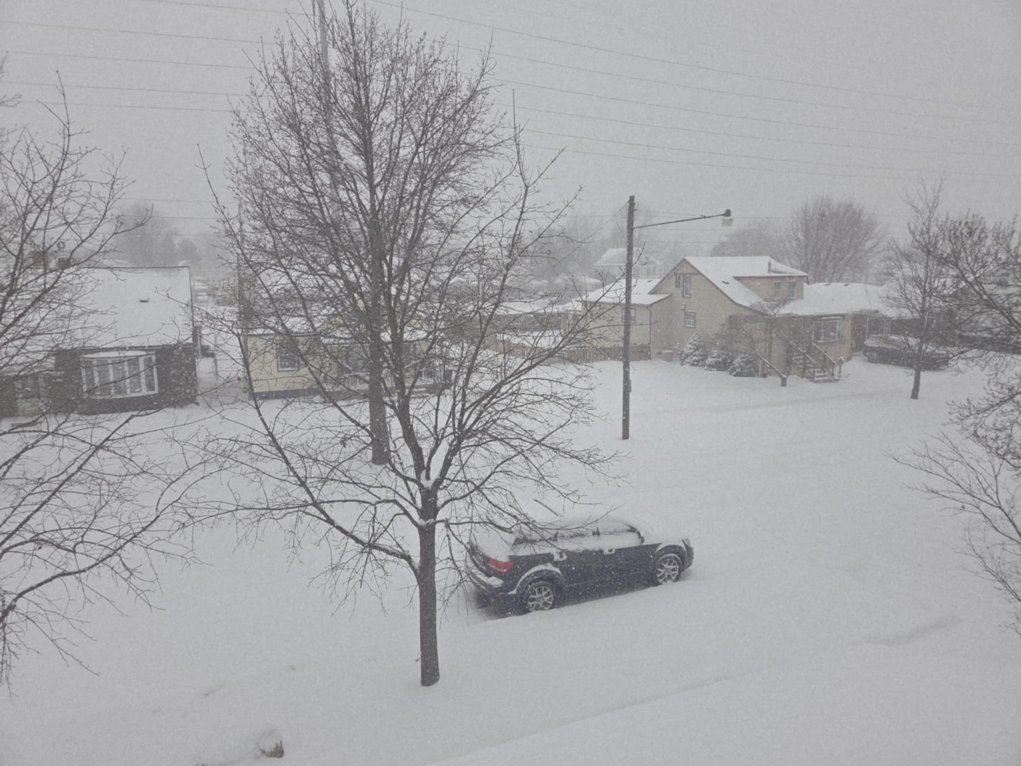
Took this around 9am
-
I know it doesn't and I've said that I'm just saying I haven't recalled many experiences where this dynamic has happened. So either I think maybe we warm into the 20s or the upper levels wont be as warm as modeled. I also realize this is not a normal storm by any means though.
-
 Man band approaching
 -
 Great right over me. I don't want any of it.
 -

Central PA Winter 25/26 Discussion and Obs
AccuChris replied to MAG5035's topic in Upstate New York/Pennsylvania
Measured an impressive 10” here in Lebanon before it went to mostly sleet. Big flakes mixed in but mostly sleet now…bummer…with those amazing ratios and snowfall rates, easily could have doubled the snow amount . -
 sorry to hear it, condolences.
 -

Central PA Winter 25/26 Discussion and Obs
Voyager replied to MAG5035's topic in Upstate New York/Pennsylvania
Snowstorm nooners with our heaviest rates so far... Temp: 8 Accumulation: 8 inches.
-

Extreme Cold, Snow & Sleet: SECS 1/24 - 1/26
nycsnow replied to TriPol's topic in New York City Metro
RAP which brings the sleet line into nyc Long Island quicker is still another 5-7 inches 16z hrr rolling and it’s still showing snow along the south shore at 23z -
 Appreciate the ground update. I’m right on the S Coast of Mass. So how much we sleet is still the wildcard here.
 -

January 25-26 Winter Storm Potential
Hurricane Agnes replied to Ralph Wiggum's topic in Philadelphia Region
Yup a weekend and it ended the day before my birthday. Did a birthday Jeb Walk (clear and sunny) down the middle of the plowed street along the side of my apartment building, right to the supermarket to get the usual "french toast supplies". There were 6ft plowed mounds on either side of the street with a "path" carved through them near intersections. The NAM had been showing this run after run the past couple days. All bubbling up from the south and brushing the area. Paul even posted some sleet maps. It was showing more ice chances south of here and down that way. I know I was concerned about ZR down there too. Confirmed. Started less than an hour after I cleared the board. -
Heaviest rates of the day now. Bands sort of moving in off the ocean almost. Temp stuck at 14.8
-

Southern Crippler - Get well soon Jimbo Storm Obs
olafminesaw replied to BooneWX's topic in Southeastern States
The HRRR just keeps trending colder. I don't think it's out of the question the final band is mixed with sleet. In fact that is what it is showing on P-type map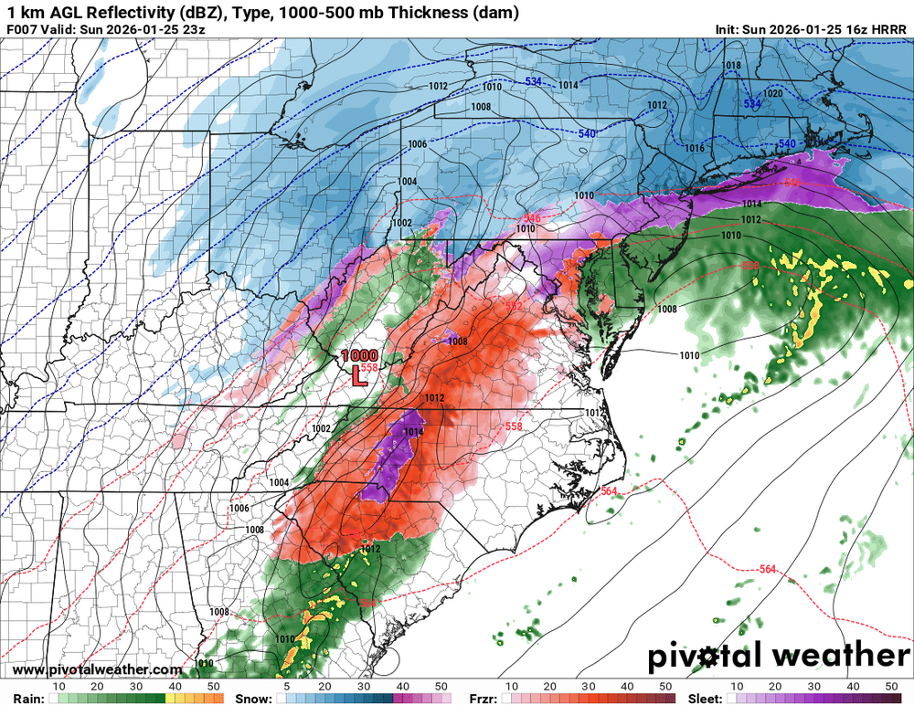
-

Extreme Cold, Snow & Sleet: SECS 1/24 - 1/26
jm1220 replied to TriPol's topic in New York City Metro
HRRR again showing sleet coming into the area but then being fought/pushed back for a while. This idea will either be the hero of the day or fall flat on its face. -

Pittsburgh/Western PA WINTER ‘25/‘26
ChalkHillSnowNut replied to Burghblizz's topic in Upstate New York/Pennsylvania
I remember by buddy from HS-who’s now chief meteorologist for WTOV9 telling me that was gonna be big-ignore what everyone was calling for-he nailed it! I remember kdka and WTAE calling for some absurd small accumulation. Wish these boards were running back then -
My temperature as the snow picked up in intensity went from 15.6 to 15.2. I guess this indicates the warm nose has not infiltrated my area yet.
-
Nah...keep the Nam nest and shoot the mother hen!
-
Up to 7” here. Watching the sleet line approach from Berks Cty.