All Activity
- Past hour
-
I’ll tell you what you won’t see on X, Judah’s final report on the voodoo Siberian snowcover advance for October. There was no miracle buildup the last week of this month
-
Records: Highs: EWR: 82 (1946) NYC: 82 (1961) LGA: 81 (1946) JFK: 79 (1961) Lows: EWR: 31 (1932) NYC: 31 (1925) LGA: 35 (2011) JFK: 30 (1962) Historical: 1844: 30 inches of snow fell during a three day storm at Buffalo Barracks, NY. (Ref. AccWeather Weather History) 1873L Lowest minimum temperature was 26° in DC and tied 10-31-1917 record. (Washington Weather Records - KDCA) 1925 - Nashville, TN, was blanketed with an inch of snow, their earliest measurable snow of record. (The Weather Channel) 1925: Richmond, Virginia had a high temperature for the day of 44 °F making it the coolest October day on record (records since 1897). (Ref. Richmond Weather Records) 1925: The earliest snow greater than one inch in Washington, DC, fell on October 30, 1925, (2.2") and October 20, 1940,(1.4"). The deepest Baltimore snowstorm ever recorded in October struck on this date in 1925, killing at least one person and blinding the rail birds at Laurel Park through all seven races. The storm dropped 1 to 3 inches of snow across the region, with an official 2.5 inches in Baltimore. That remains the deepest October snowfall on record for the city. In Baltimore, the snow began falling around 1 p.m. and continued into the evening, even as surface temperatures remained above freezing. 1947 - The Donora, PA, smog disaster finally came to an end. For five days an inversion trapped impurities in the lower atmosphere over the Monongahela Valley killing 20 persons, and leaving more than 2000 others sick. (26th-30th) (David Ludlum) (The Weather Channel) 1949: Haines Junction recorded The Yukon Canada’s greatest daily snowfall record as 26.5 inches fell. (Ref. Wilson Wx. History) 1987 - Severe thunderstorms in Oklahoma produced golf ball size hail and wind gusts to 74 mph near the town of Gould. Unseasonably warm weather prevailed across the central U.S. Temperatures warmed into the 80s form Texas to the Lower Missouri Valley. (Storm Data) (The National Weather Summary) 1988 - Ten cities in the Upper Midwest reported record low temperatures for the date. The morning low of 20 degrees at South Bend IND was a record for October, and lows of 18 degrees at Grand Rapids MI and 20 degrees at Fort Wayne IND equalled records for October. The low of 2 degrees at International Falls MN smashed their previous record for the date by 11 degrees. Syracuse NY received 2.9 inches of snow to establish a record for October with 5.7 inches for the month. (The National Weather Summary) (Storm Data) 1989 - Temperatures soared into the 70s in the northeastern U.S. The record high of 73 degrees at Alpena MI marked their sixth straight day of record warmth. In the western U.S., Klamath Falls OR reported a record low of 19 degrees. (The National Weather Summary) 1991: The Perfect Storm, also known as the No-Name Storm reached maximum strength on this day with a low pressure of 972 mb and sustained winds of 69 mph. 1991: After absorbing Hurricane Grace on the 29th, an intense ocean storm at 972 millibars or 28.70 inches of mercury, known as the Perfect Storm. The storm took a very unusual course and moved westward along 40°N and battered eastern New England with high winds and tides. Winds had already been gusting over 50 mph along the coast two days before. Major coastal flooding and beach erosion occurred all along the New England, New York, and New Jersey coastlines. Over 1,000 homes were damaged or destroyed from tides anywhere from 4 to 7 feet above normal. North Carolina's coast was lashed with occasional winds of 35 to 45 mph for five consecutive days. Other high wind gusts included: 78 mph at the Chatham NWS, 74 mph at Thatcher Island, 68 mph at Marblehead, 64 mph at Blue Hill Observatory (all in Massachusetts) and 63 mph at Newport, RI. Waves 10 to 30 feet high were common from North Carolina to Nova Scotia. In New Jersey, the greatest tidal departures of winter storms of record occurred during this event, with tide heights exceeded only by the Great Atlantic Hurricane of 1944. In Delaware, Maryland, and Virginia, the highest water levels were comparable to those of the nor'easter of March, 1962. A record high tide of 7.8 feet occurred at Ocean City, MD on the 30th, which eclipsed the old record of 7.5 feet recorded during the March 1962 storm. In Massachusetts, 25-foot waves reached the shoreline atop high tides already 4 feet above normal. At Boston, the tide reached 14.1 feet above mean low water or about 1 foot less than the tides associated with the "Blizzard of 1978. " One ship east of New England reported a 63 foot wave. Heavy rain continued into November 1st. Blue Hill Observatory in Milton, MA ended up with 5.76 inches of rain. Total damage from the storm exceeded $200 million dollars. (Ref. AccWeather Weather History) 1991: A strong winter storm brought southwest Kansas its first snowfall for the year, dumping up to 14 inches in Garden City. A large storage shed collapsed due to heavy snows in Johnson, and slippery roads caused a lot of havoc and claimed the life of a child in an automobile accident. Bitter cold temperatures also accompanied the heavy snows, and wind gusts to 45 mph brought wind chills down to -20°. The frigid conditions and blowing snow claimed the lives of two men, both of exposure in separate incidents, when they left their cars after they got stuck. Both men tried to make their way back home. (Ref. The Perfect Storm ) (Ref. Wilson Wx. History) 1991: Billings, MT dipped to -7 °F which set a new record low for the month of October and it was the first time the station had even been below zero in October. Other October record lows included: Sheridan, WY: -9 °F and Miles City, MT: -8 °F, Scottsbluff, NE equaled their record for the earliest below zero temperature recorded with a low of -1 °F. (Ref. Wilson Wx. History) 1993: Record cold and snow occurred in the central and southern U.S. Cincinnati, OH recorded 5.9 inches of snow for its greatest October monthly snowfall ever. San Antonio, TX saw flakes for the first time ever in October. Laramie, WY plunged to 18° for its coldest reading on record for October. The 12° reading at Amarillo, TX set the same record. (Ref. AccWeather Weather History) 2004: Exceptionally heavy rains drenched the Manoa Valley near Waikiki in Hawaii. 10 inches of rain fell at the Manoa Arboretum in just 12 hours, causing flooding that rushed through the University of Hawaii's main research library. (Ref. Wilson Wx. History) (Ref. WxDoctor) 2012: Hurricane Sandy continues to loom ominously off the U.S. east coast, bringing very heavy rain and tropical storm to hurricane force winds to many millions of people well before the worst arrives. The coastal flooding is already terrible, as expected (even as far south as Miami and Fort Lauderdale!). Locations from North Carolina to Maine will continue to see incredible coastal flooding/erosion, with the worst near and north of where the center crosses land (approximately southern NJ into NYC, Long Island). Inland flooding will also be a large problem in the coastal states as well as the inland states throughout the northeast. Finally, the 50-90mph winds that many places will experience can easily damage roofs, break tree limbs, and uproot trees, bringing power lines down with them. Superstorm Sandy. October 28-29. Category 1 Hurricane Sandy transitioned into a monstrous extratropical storm while making landfall along the New Jersey coast, resulting in one of the most intense and damaging East Coast storms of all time. Surging Atlantic waters (8-14 feet) inundated the Jersey shore and low-lying areas of NYC and Long Island, causing estimated damages of at least $60 billion. The storm caused 72 direct deaths (87 indirect) in the United States, the loss of power to 8.5 million homes and businesses, and the cancellation of more than 18,000 airline flights.
-
-

Spooky Season (October Disco Thread)
CoastalWx replied to Prismshine Productions's topic in New England
Could be a crazy 2-3hr period of heavy rain and wind at peak. -

Correlation of extreme hurricanes, AGW, and solar cycles
bluewave replied to WolfStock1's topic in Climate Change
-

Major Hurricane Melissa - 892mb - 185mph Jamaica landfall
BooneWX replied to GaWx's topic in Tropical Headquarters
I think what you are describing was when Super Typhoon Haiyan made landfall near Tacloban, Philippines. Come to think of it, that means Josh has been in the most intense Pacific landfall and the most intense Atlantic landfall in the satellite era. This is a discussion for a different thread but this is why after yesterday, I’ll regard him as the greatest chaser of all time moving forward. -
The 2025 rendition of the warm Pacific may signify something else. Not directing this at you, per se, but to the general audience. The warm Pacific "blob" as it's called is not forcing patterns - nor subsequently constructing the winter pattern biases. The blob exists due to a long duration applied wind stresses, distributing and redistributing warm surface mass in the ongoing quasi-coupled atmospheric-oceanic system. That forcing disributes warmth vs upwelling and cooling ..etc, over time, and it is a shallow thermal distribution response ( SSTs ). We've spent time explaining this in the past, and to the same group of individuals that frequent this social media ... but given some time ... we're back to reading posts that sound like the blob is going to cause the winter pattern? - false if that's the thinking. What needs to be done is a study that correlates the blob occurrences in both space, time, and amplitude, against the preceding hemisphere's synoptic footprint. It's far in a way more likely that 2013's Pacific thermal layout/phenomenon is connected to a pattern that was going on, and led to both: creating the blob, while also ensuing the Chicago record cold that winter. The pattern created both. Not the other way around. That said, there may be some predictive usefulness in using the warm vs cool Pacific distribution whence any such correlation can be assessed. In 2025, the Pacific looks similar to 2013 - which means, given the above facets, there has likely been similarities in the distribution of surface oceanic stressing patterns to date. But here's the problem: Does it persist? That's the key question. Unfortunately, nothing about 2013 vs 2025 predicts that very clearly. Having nothing else to really go on at that point, ...yeah, it's not unreasonable to look for that persistence - but there really shouldn't be any presumption there, either. For one, different synoptic variances may lend to similar distributions, where one variance lends to a 2013, but the other does not. So if-so variances would also need to be defined.
-
 Wind just picked up. Gust to 33
 -
(002).thumb.png.6e3d9d46bca5fe41aab7a74871dd8af8.png)
Central PA Fall Discussions and Obs
ChescoWx replied to ChescoWx's topic in Upstate New York/Pennsylvania
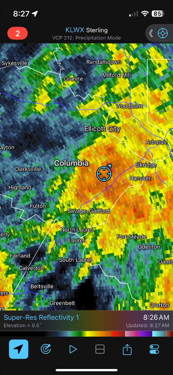
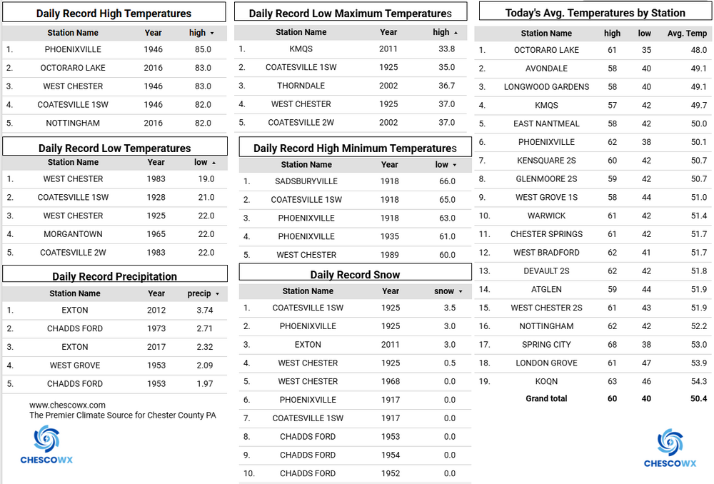
Rainfall so far since last night East Nantmeal 0.75" / Warwick Twp. 0.83" / Nottingham 1.12" / Glenmoore 0.96" / Chester Springs 0.74" / Kennett Square 0.85" / West Bradford Twp. 1.04" / Devault 0.71" / West Chester 0.89". Some spots could see up to another 1" to 2" today. The rain should end this evening. Between the rain today and wind tomorrow we should see quite a few of the remaining leaves coming down by tomorrow night. Temperatures near to below normal look to continue through much of the next week.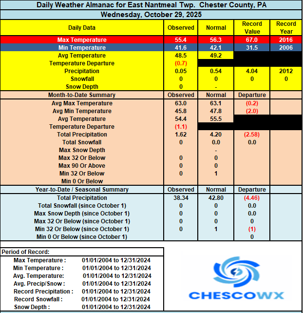
-
58 / 57 - moderate rain with 0.40 already with 1 - 3 in totality. Dries out later this evening and slowly clear out later Friday. Nice dry / fall weekend coming up. Overall near normal / slightly above through the first week.
-
When I get my money right, I’m getting a cabin somewhere in your neck of the woods. Snow capital of NC.
-
E PA/NJ/DE Autumn 2025 Obs/Discussion
ChescoWx replied to PhiEaglesfan712's topic in Philadelphia Region
Rainfall so far since last night East Nantmeal 0.75" / Warwick Twp. 0.83" / Nottingham 1.12" / Glenmoore 0.96" / Chester Springs 0.74" / Kennett Square 0.85" / West Bradford Twp. 1.04" / Devault 0.71" / West Chester 0.89". Some spots could see up to another 1" to 2" today. The rain should end this evening. Between the rain today and wind tomorrow we should see quite a few of the remaining leaves coming down by tomorrow night. Temperatures near to below normal look to continue through much of the next week.
-
https://x.com/RyanMaue/status/1983257269790802411?t=jXBvJLcSdaQKQ2crQ3oqQg&s=19
-
E PA/NJ/DE Autumn 2025 Obs/Discussion
ChescoWx replied to PhiEaglesfan712's topic in Philadelphia Region
Looks like we are well on our way with some spots already over an inch....we need it! -
Just absolutely pouring here. I’m dreaming of the winter.
-

2025 Atlantic Hurricane Season
NorthHillsWx replied to BarryStantonGBP's topic in Tropical Headquarters
Melissa has now surpassed Erin in total ACE, becoming the highest ACE producing storm of the season, second storm of the season with >32 and third storm >26. I know people forecasted a backloaded season but to only have 5 hurricanes and get a basin seasonal ACE of likely ~140 is impressive. -
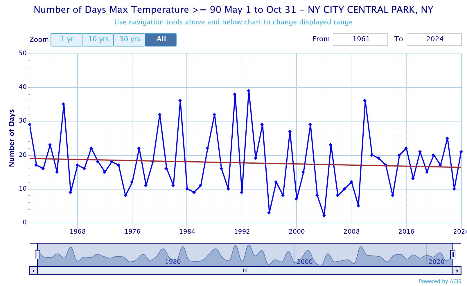
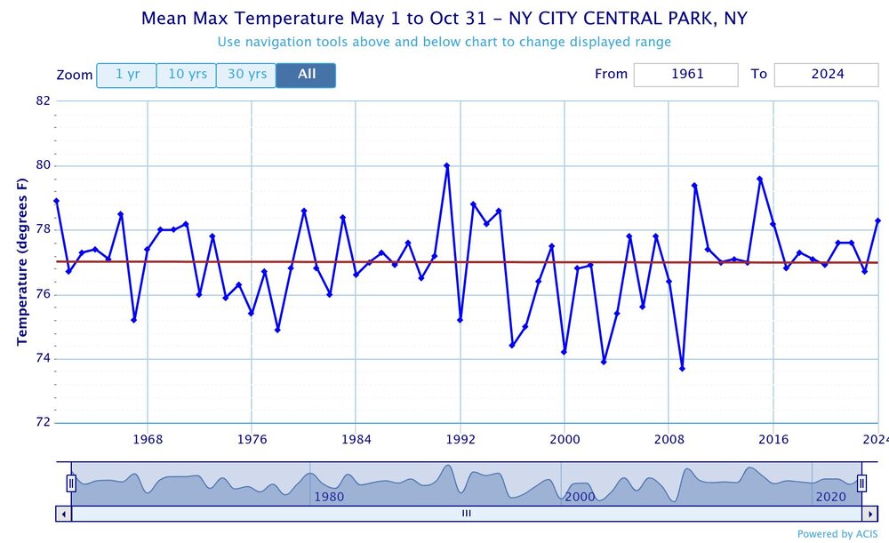
Yeah, without the tree growth NYC should be closer to LGA even in October. Notice how much of a difference there had been between when the trees are fully leafed out vs when the leaves drop. Since 90° days are sunny you see the artificial decline more on those days. Fully leafed out No leaves
-
 Moderate rain here
 -

Spooky Season (October Disco Thread)
cleetussnow replied to Prismshine Productions's topic in New England
Snow sticks around -

Spooky Season (October Disco Thread)
Snowcrazed71 replied to Prismshine Productions's topic in New England
Looks like a nice big plume of moisture is developing off the coast of North Carolina. There are two bands that look like they are going to connect as they make their way North. That's probably going to be our heavy rain later this afternoon to this evening. -
Well that was unexpected!

-
Looking at guidance I think this is it once it's done. Save for maybe a few isolated showers. Not much I've seen has a late morning or afternoon line.
-
Nevermind LOL! It shifted just west at the last minute. The dome is in effect after all
-

Spooky Season (October Disco Thread)
GCWarrior replied to Prismshine Productions's topic in New England
I did a 8 day wilderness camping trip in the flatter western part of the ADK park, north Herkimer County. I can say at lower elevation we experienced most nights at -20F with two below -30F. It was a very wintery vibe indeed. -
Getting the goods