
EstorilM
-
Posts
123 -
Joined
-
Last visited
About EstorilM

- Birthday 06/11/1984
Recent Profile Visitors
1,347 profile views


-
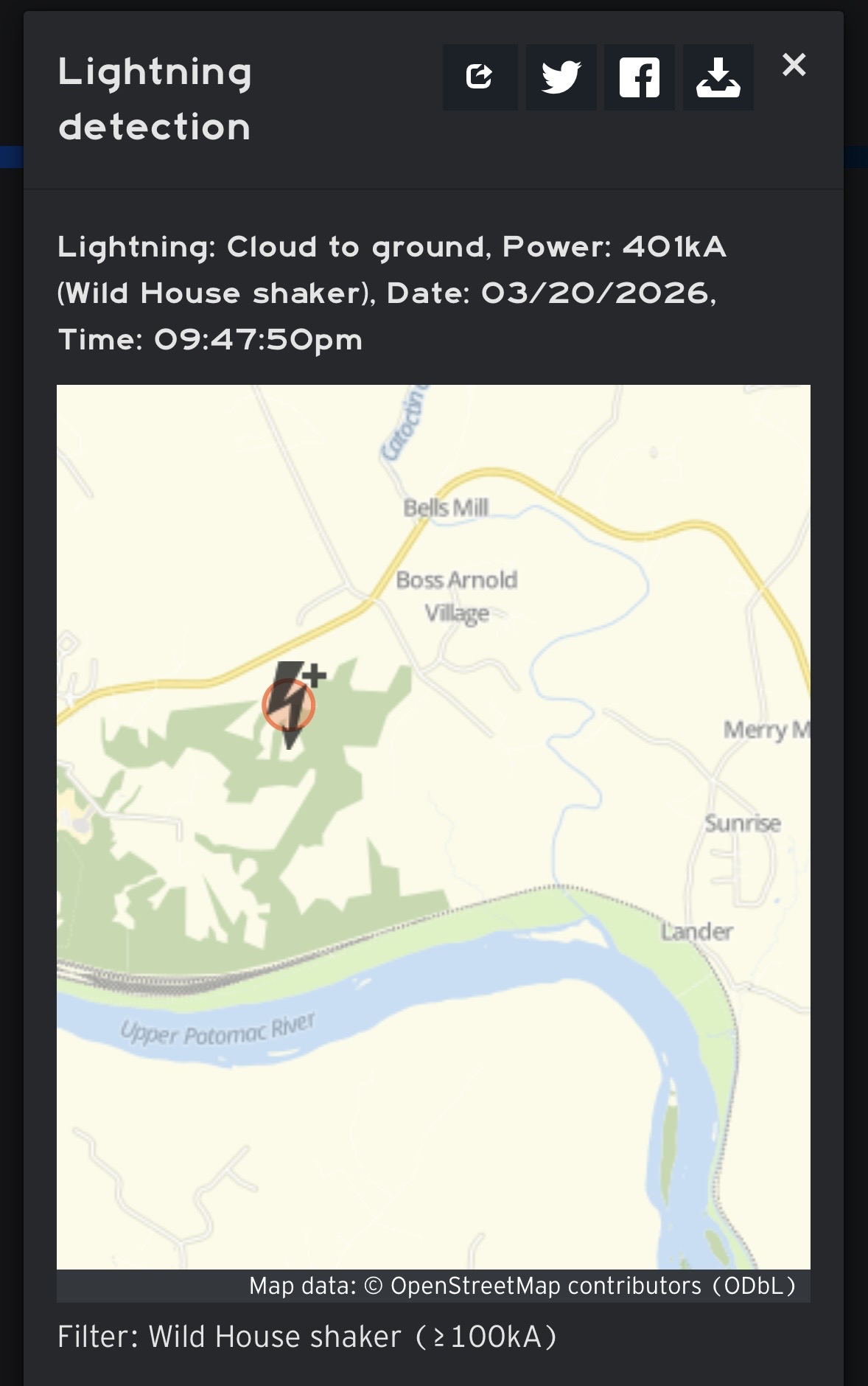
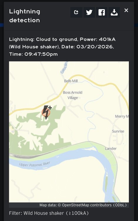
Looks like weather.us …also, wouldn’t this be up there with some of the most powerful strikes ever recorded? At least around here? Average is like 30kA right? I did NOT think there were any unique atmospheric variables at play last night.
-
Wow what a night (unexpected!) I shall dub the mystery bolt as the “Brunswick Boomer!” Both my weather stations with lightning detection picked it up, somehow with fairly accurate distances too (10mi from my Middleburg station near goose creek, 16mi from my Catharpin station towards Manassas.) Then I was woken up again to lots of lightning and thunder as the training storms eventually aligned with me, and I got that impressive cell for a good 10 minutes (peaked out at just under 1”/hr .3 total, nothing too wild. These were some pretty impactful storms, especially the training action. There wasn’t so much as a single peep about any of this in the forecast discussion from LWX, just the showers earlier with the fropa around the evening commute. What an exactly happened from a meteorological perspective? Aren’t things usually pretty dry and stable hours after a front has passed?
-
 That looks absolutely stunning on the high res velocity playback. I was watching that area as the gust front propagated out and triggered this - all happened very quickly.
 -
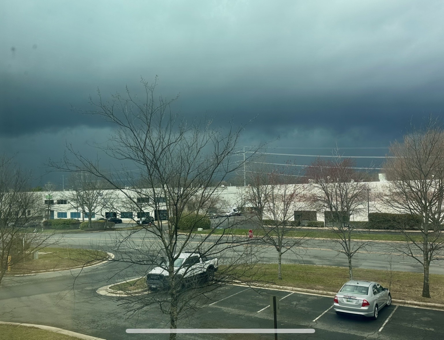
Wow I just can’t catch a break today. The portion of this line that was going to hit me seems to have collapsed right as it got here, with a pronounced outflow boundary followed by almost instantly triggering a pretty serious new chunk in its wake (after it was long past me.) Immediately got a severe tstorm warning too.
-
Well they just dropped the tornado watch for most of us.
-
I get that vibe as well - I just can't imagine this second round doing much with the conditions I'm looking at through the window. Isn't this pretty much exactly what the high res guidance was showing late last night?
-
Wow just got hit with a tornado warning, basically going straight into Sterling LWX office.
-
SPC just issued a new MD for 60% tornado watch issuance for a lot of us. https://www.spc.noaa.gov/products/md/md0269.html
- 1,093 replies
-
- 1
-

-
- severe
- thunderstorms
- (and 1 more)
-
There’s kinda a separate northern element to that part of the line going into Culpeper, I think that misses most of NoVA to the northwest
-
My three PWS (Middleburg, Leesburg, Manassas) are 66.2/63.5, 66/63.6, 65.8/62.8. That's kinda wild that all three's temp/dp are within a single degree.
-
They'll be waiting for a bit - if you look at the SPC MD's you can get a better idea - its still too far south for LWX to get into the action. It's possible within the hour or so I'd guess.
- 1,093 replies
-
- 2
-
-
- severe
- thunderstorms
- (and 1 more)
-
Exactly what I've been thinking, we've got a ton of shear, plenty of lift, and good moisture - we've seen plenty of historically significant weather events / tornadoes triggered by strong frontal systems with less than 1000j/kg (sometimes much less, initiation after dark, etc.)
-
lol that's exactly what I just told someone at work (re 9-10am we'll get a "feel" for the day so-to-speak.) Then again, there are still a LOT of ingredients at play here beyond cape. Mets seem to think there's sufficient lifting, so we may not be too dependent on daytime heating. It'll still be an interesting day regardless... and it looks like those winds will almost certainly mix down either way as well.
- 1,093 replies
-
- 1
-
-
- severe
- thunderstorms
- (and 1 more)
-
Yeah I'd much rather trade that in for two rounds lol - I think that first round might really ruin things for us, but who knows. My primary PWS in Middleburg is already 64 deg w/ DP of 62.8.