All Activity
- Past hour
-
Eh it was the Euro also that broke hearts. It was the Euro that first corrected but then the GFS did as well. I honestly think at this range the GFS is handling the storm better but we will see. Euro has had this storm on and off. It has it now. It's just suppressed.
-

Pittsburgh/Western PA WINTER ‘25/‘26
colonel717 replied to Burghblizz's topic in Upstate New York/Pennsylvania
-
Taint up to I-80 May need to revisit those Valentine's Day 2007 discussions
-

Possible Record Breaking Cold + Snow Sunday 1/25 - Tuesday 1/27
mikem81 replied to TriPol's topic in New York City Metro
The NAM will change every single run to something else. That is what is does. Period. -

January 25-26 Winter Storm Potential
mattinpa replied to Ralph Wiggum's topic in Philadelphia Region
I wouldn’t trust it unless it gets support. The NAM can be prone to extreme runs both ways. -

Possible Record Breaking Cold + Snow Sunday 1/25 - Tuesday 1/27
psv88 replied to TriPol's topic in New York City Metro
Flips us to plain rain! Awful. -

Jan 24-26 Weekend Snow and Sleetfest Model Thread Part Tres
Yeoman replied to H2O's topic in Mid Atlantic
HRRR is worthless for predicting band placement until it's inside 18 hours -

January 25-26 Winter Storm Potential
PhiEaglesfan712 replied to Ralph Wiggum's topic in Philadelphia Region
The HECS was in March 1958. This followed another HECS on Valentine's Day that year. 1957-58 was that era's snowmageddon. In many places, it still holds the record for the snowiest season on record. That was a strong el nino year, like 2009-10, which produced the snowmageddon. The crazy thing about 2009-10 is how quickly that winter wrapped up after the snowmageddon event. It legit felt like summer during the first week of April that year. -

Pittsburgh/Western PA WINTER ‘25/‘26
MikeB_01 replied to Burghblizz's topic in Upstate New York/Pennsylvania
Primary for the NAM was stronger. That allowed it to amplify a little more. -
whoof..
-
Ya that's way north with the sleet line.. maybe a 18z blip
-

Jan 24-26 Weekend Snow and Sleetfest Model Thread Part Tres
balltermen replied to H2O's topic in Mid Atlantic
soundings maybe imply snow until 14-15z. it's after that that the nose goes full pinocchio. I think it's too warm. But if models trend toward an 8-9 am flip it's a 4-6" snow and then maybe 2-3" sleet. I figure a blended ratio of 12:1 for the snow portion here. I think 6-10" incl sleet is still the right forecast for now. -
NAM is sort of a torch lol
-

Pittsburgh/Western PA WINTER ‘25/‘26
Burghblizz replied to Burghblizz's topic in Upstate New York/Pennsylvania
We’ll see if it holds on to this at 0Z. I wish for the southern guys it pulled back a little on the tongue - but I still think everyone is fine given it’s about the most north guidance there is. Totals should still look pretty NAMMY for most. -
Looks like I hit the 'high' today about 2 pm at 42.2 degrees. Now down to 40.5/8.1 with WNW wind 15 gusting to 31 mph. Yeah ANOTHER windy day, just shocked!
-

“Cory’s in LA! Let’s MECS!” Jan. 24-26 Disco
TauntonBlizzard2013 replied to TheSnowman's topic in New England
Until something else reputable shows anything close to that. Chuck it. I would be concerned about any mixing unless I was like 5 miles from The coast, and even then, damage is done -

Central PA Winter 25/26 Discussion and Obs
paweather replied to MAG5035's topic in Upstate New York/Pennsylvania
Still we will makeout on accums -

Possible Record Breaking Cold + Snow Sunday 1/25 - Tuesday 1/27
jm1220 replied to TriPol's topic in New York City Metro
Yep pretty much back to 6z where mixing gets to almost all of CT and RI. Thankfully it’s on its own pretty much and other models got colder at 12z but a SWFE like system such as this will take any chance it can get to nudge north unless confluence stops it. -

Possible Record Breaking Cold + Snow Sunday 1/25 - Tuesday 1/27
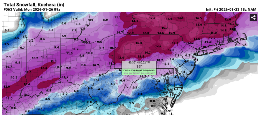
SACRUS replied to TriPol's topic in New York City Metro
1/23 18z NAM total qpf storm Total snow/ sleet / frz rain (10:1) -

Jan 24-26 Weekend Snow and Sleetfest Model Thread Part Tres
MN Transplant replied to H2O's topic in Mid Atlantic
We took a step backwards with a stronger (the strongest yet) 850 low in Ohio. -

1/24-1/25 Major Winter Storm - S. IL, IN, and OH
Baum replied to A-L-E-K's topic in Lakes/Ohio Valley
Thank you for a polite and cruel summary as to why I’m screwed. But do appreciate the solid analysis. -

Possible Record Breaking Cold + Snow Sunday 1/25 - Tuesday 1/27
Stormlover74 replied to TriPol's topic in New York City Metro
Yeah we need that thump to perform if we're getting anywhere near double digits -

“Cory’s in LA! Let’s MECS!” Jan. 24-26 Disco
SouthCoastMA replied to TheSnowman's topic in New England
Could still be glue. -
Likely just Methuen...
-
“Cory’s in LA! Let’s MECS!” Jan. 24-26 Disco
TauntonBlizzard2013 replied to TheSnowman's topic in New England
Tossed. Going to need more support than that


