All Activity
- Past hour
-
Just wanted to clarify since some would assume it covered the entire days activities.
-
The steady rain in NE PA is drying up. All these things are great signs. Full steam ahead for mid to late afternoon.
-
You don’t say
-
Should be getting a MCD soon, probably in next hour
-
This is only regarding the morning threat.
-

2026 Mid-Atlantic Severe Storm General Discussion
batmanbrad replied to Kmlwx's topic in Mid Atlantic
visible does seem to show some decent clearing as you get west of MoCo...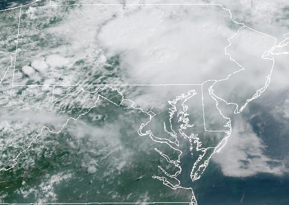
-

Central PA Summer 2026 Discussion/Obs Thread
canderson replied to Voyager's topic in Upstate New York/Pennsylvania
Heavy rain now -
Drive north where it’s pouring in Hershey. So we’re at Troegs until it stops haha
-
Had a heavy downpour with thunder in Carteret. In a lull now, just dark.
-
Looks like things are dying as they march east, which comes as no surprise for most of LI. Especially, along the south shore in western Suffolk.
-
Just lost power in Wantage. We didn’t even get a storm yet. We didn’t even lose power on July 3rd. We’re throwing a grad today. We already have it set up to be inside. But, no power already? Getting windy, though.
-
 Torrential downpours here with loud thunder and frequent lightning.
 -
Sky has brightened
-
Torrential downpours here with loud thunder and frequent lightning.
-
Central PA Summer 2026 Discussion/Obs Thread
canderson replied to Voyager's topic in Upstate New York/Pennsylvania
Incredibly loud thunder and it’s as dark as night -
https://www.spc.noaa.gov/products/md/md1645.html Mesoscale Discussion 1645 NWS Storm Prediction Center Norman OK 1001 AM CDT Sat Jul 18 2026 Areas affected...Northern Mid-Atlantic into southern New England Concerning...Severe potential...Watch unlikely Valid 181501Z - 181630Z Probability of Watch Issuance...20 percent SUMMARY...Isolated wind damage is possible with strong to marginally severe storms late this morning. A watch is not expected. DISCUSSION...A small linear cluster of storms has recently organized in northern New Jersey and adjacent northeast Pennsylvania. Storm cores have shown modest deepening on 7 km MRMS CAPPI over the last 30 minutes. The observed OKX sounding had poor mid-level lapse rates (5.3 C/km) but 45 kt of effective shear. Downstream of this current activity, cloud cover and smoke have hindered surface heating. Low-level lapse rates are not expected to be overly steep. While isolated wind damage is possible late this morning, the severe threat should remain marginal on account of very limited buoyancy. A watch is not expected. ..Wendt/Thompson.. 07/18/2026
-
S winds being reported on the 11am obs up to BWI... 84/75 S at 9 at DCA... C VA like CHO, Culpepper, EZF already upper 80s
-

Central PA Summer 2026 Discussion/Obs Thread
Blizzard of 93 replied to Voyager's topic in Upstate New York/Pennsylvania
Heavier rain in Marysville with occasional thunder. -
models are unreliable in these setups = now casting time using radars and this smoke is still hanging in there making the sky look strange
-
It's inside, but I have bad luck of getting recalled for work when I finally get a date day with the wife.
-
SPC has moved marginal risk westward into middle TN for 5% wind also did you check out SPC discussion a upgrade to 60% for wind in the already 45% wind in mid Atlantic New England area .
-
I'm wondering about that batch of rain moving in from PA as well
-
And the funny thing is, remember how I mentioned that yesterday's 12z HRRR nailed our area today around 10 in the morning. That HRRR run yesterday ended up being correct, but future runs lost it. It's such an inconsistent model, but it's certainly useful at times.
-

Saturday, July 18, 2026 Thunderstorm/Severe Weather Potential
Damage In Tolland replied to weatherwiz's topic in New England
What do you think on timing?