All Activity
- Past hour
-

2026-2027 El Nino
40/70 Benchmark replied to Stormchaserchuck1's topic in Weather Forecasting and Discussion
It makes perfect sense to me that if the essence of El Nino is anonymously warm water modulating the Hadley Cell via enhanced convective activity, then warming up the water to the west of ENSO is going to reduce it's ability to do so because the MC is going to rob the ENSO region of some of that convection....ie it's a competing force. This is why the RONI is GREATER than the ONI during cool ENSO because we are then STRENGHTENING the thermal contrast, and enhancing the convection over the warmer MC waters. -
I keep having to remind myself it's just the first week of April... It's just a slog, this time of year.
-
Whopping 0.02" and not a drop in the forecast. Sprinkler's a comin'.
-
2026-2027 El Nino
40/70 Benchmark replied to Stormchaserchuck1's topic in Weather Forecasting and Discussion
I am willing to bet that if we were to ditch the gap between the RONI and ONI, or even have the ONI lag the RONI, we would get lower heights in the southeast....my guess is in order achieve that we are going continue to have to see that western Pac warmth spread eastward, which would help to reduce that persistent, residual cool ENSO residue. Again, don't mistake me overvaluing the RONI in-and-of-itself....it's what it represents, which is the surplus of western Pacific warmth relative to the eastern Pacific reducing the ability of +ENSO to couple with the atmosphere, and thus modulate the northern Pacific in the manner that we would like. -
Had a low of 35 degrees this morning.
-
2026-2027 El Nino
40/70 Benchmark replied to Stormchaserchuck1's topic in Weather Forecasting and Discussion
I was wondering about that...how do we trust such aged data...that said, I am not going to contest the fact that ambient heights were lower back then. -
2026-2027 El Nino
40/70 Benchmark replied to Stormchaserchuck1's topic in Weather Forecasting and Discussion
2015 having a weaker se trough relative to 1997 is entirely consistent with what I am proposing, since the RONI lagged the ONI in 2025, and it did not in 1997. I made the same mistake in 2015 that I did in 2023 in mistaking the warmer west Pacific for more of a Modoki signal. I will not do that again. -
A few flurries here. 36°
-
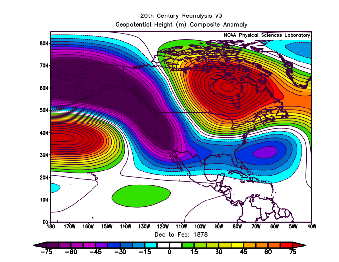
Chris, I’m curious. How is it possible to come up with even approximate geopotential hts for way back in 1877-8?
-

2026 Spring/Summer Mountain Thread
franklin NCwx replied to Buckethead's topic in Southeastern States
Got just over 2.5 inches with the rain Friday morning included. Had a low of 39 this morning -
Yeah, I guess I didn't pay attention because I was not expecting that. Only a dusting at my place but nothing here at the office in Waterbury.
-
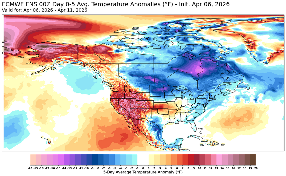
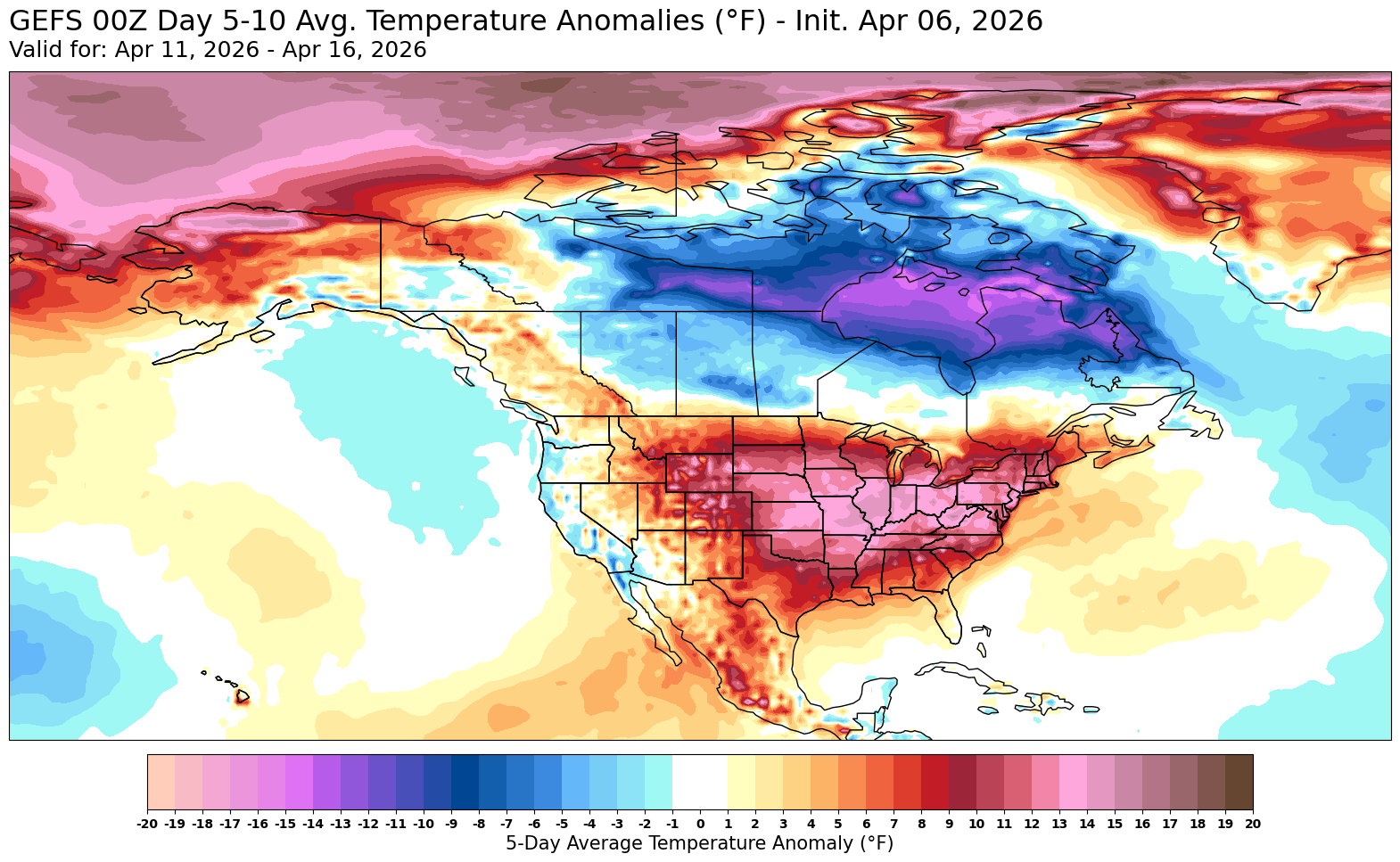
Looks like this week will feature some of our coolest temperatures until next fall before our next rebound warmer.

-

2026-2027 El Nino
bluewave replied to Stormchaserchuck1's topic in Weather Forecasting and Discussion
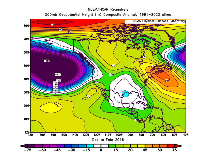
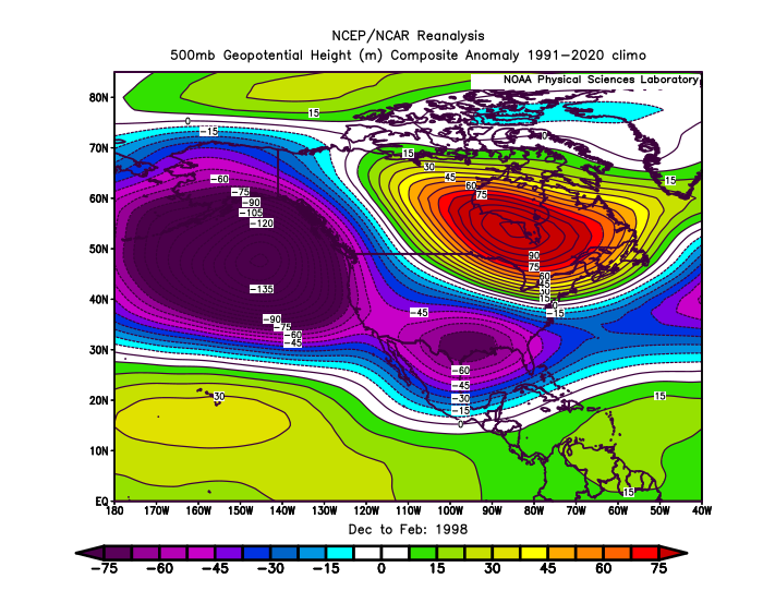
Perhaps if the RONI is in better alignment with the ONI next winter than 2023-2024 there will be a stronger Aleutian Low and trough in the SE and MA. But I am really not sure about that yet since even 2015-2016 had weaker troughing compared to 1997-1998. Could also be a function of the warm pool in the North Pacific expanding outside the traditional -PDO and +PDO bounds with the record 2nd EOF. 2023-2024 Nino ridge to north in super mode like 1997-1998 but the Aleutian Low and SE and MA trough showing a Niña-like influence with big RONI and ONI spread. 2015-2016 Aleutian Low well developed but the SE and MA trough in the East very weak. Perhaps reflecting the record WPAC warm pool leading to the Niña-like record MJO 5. 1997-1998 last traditional looking super El Niño both to the north and south across North America with strong ridge and trough development. 1877-1878 super El Niño more traditional like 1997-1998.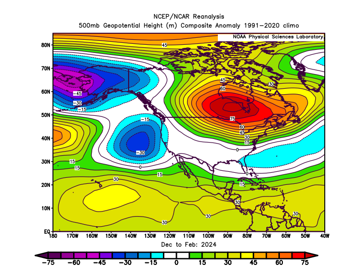
- Today
-
Low of 43 imby. WC at the Bear Rocks station in dolly sods is 10 this morning. That'll wake you up in April.
-
Thank you @Scarlet Pimpernel
-
(002).thumb.png.6e3d9d46bca5fe41aab7a74871dd8af8.png)
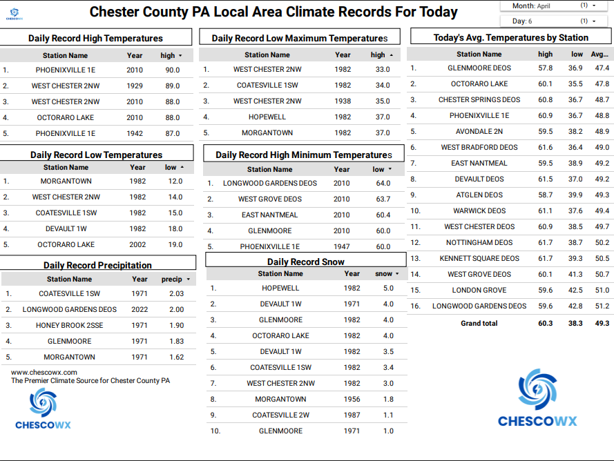
Central PA Spring 2026 Discussion/Obs Thread
ChescoWx replied to Voyager's topic in Upstate New York/Pennsylvania
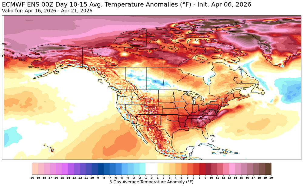
Some unseasonably cold temperatures through mid-week including a hard freeze tomorrow night into Wednesday morning. Temperatures will remain in the upper 40's which is a solid 10 degrees below normal for the date. We slowly modify to slightly above normal temperatures with highs in the mid to upper 60's by the weekend. Looking ahead to next week we should see a big warmup well into the 70's before another cool down back to below normal temperatures by late next week. Overall, a dry pattern throughout the period.

-
E PA/NJ/DE Spring 2026 Obs/Discussion
ChescoWx replied to PhiEaglesfan712's topic in Philadelphia Region
Some unseasonably cold temperatures through mid-week including a hard freeze tomorrow night into Wednesday morning. Temperatures will remain in the upper 40's which is a solid 10 degrees below normal for the date. We slowly modify to slightly above normal temperatures with highs in the mid to upper 60's by the weekend. Looking ahead to next week we should see a big warmup well into the 70's before another cool down back to below normal temperatures by late next week. Overall, a dry pattern throughout the period. Albedoman will not be pleased!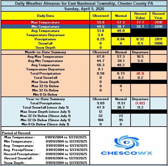
-
Wind is cranking
-
extended looks good after a bit of zzzzs here
-
It will be nice to get the ground dried out for spring yard work, hiking etc. I think everybody in SNE is out of the drought conditions now.
-
Definitely a drier look on ensembles…especially SNE.
-

Central PA Spring 2026 Discussion/Obs Thread
pawatch replied to Voyager's topic in Upstate New York/Pennsylvania
37 degrees this morning, fired my coal stove back up yesterday for probably a few days. .28” of rain yesterday and highest wind gust 37mph. -
It’s white again outside. What a whiplash. Snowing pretty hard currently.
-
Glad we’ve been getting good rain recently. Time to warm the soil.
-
What trough or front went through around 2am? Wind woke me up. Tree was banging against the roof and really moving around.


.thumb.png.4150b06c63a21f61052e47a612bf1818.png)


