All Activity
- Past hour
-
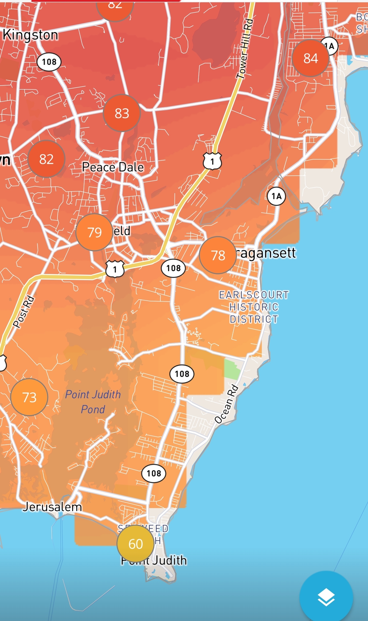
My sister has a rental house out on Pt Judith in Narragansett. I spent last spring/early summer living there and working on it. Place is like 60 degrees all the time. I would drive up to Home Depot near Providence and its like a 30-35 degree difference. Took this screenshot yesterday. Me and my brother in law setup a Wunderground station. Its the 60 degree reading on the bottom. Place barely even hits 80 in July/August.
-
Same here. Forests definitely help with cooling. Really hating all the stripped Forests to put up Solar Panels farms
-
Wednesday afternoon up in the air per morning AFD from LWX A strong area of low pressure moves through the Northeast on Wednesday, with a cold front extending down the East Coast that will bring widespread rain and thunderstorm chances to the Mid-Atlantic in the afternoon/evening. While the center low will be well north of us, the timing of the front aligning with the diurnal cycle and the high temperatures seen at the start of the week could still contribute towards some thunderstorm development in the region. Potential severity at this time still ranges widely--NCAR`s AI NWP Convective Hazards Forecast currently has our region outlined in its 45%-60% probability for severe weather to occur, while CSU`s medium- range probabilities ranks the severe threat much lower. Regardless, this front will likely result in widespread showers at a minimum as well as a sharp drop in temperatures seen later in the week. Highs on Thursday will range in the upper 60s and low 70s, a marked shift from the mid-90s expected earlier in the week. Lingering rain showers may still be moving out of the area by Thursday morning, while a meandering front to the south could bring a few additional rain showers on Friday.
-

2026-2027 Strong/Super El Nino
GaWx replied to Stormchaserchuck1's topic in Weather Forecasting and Discussion
Weekly relative SSTa update: Nino 3.4 slight rise to +0.5 (Nino threshhold): Cal wk midpt…...1+2……...3….…..3.4……..…4 01APR2026 0.8 -0.3 -0.3 0.2 08APR2026 1.1 -0.1 -0.2 0.3 15APR2026 1.2 0.2 0.1 0.6 22APR2026 0.9 0.3 0.2 0.5 29APR2026 0.7 0.5 0.4 0.5 06MAY2026 1.0 0.6 0.4 0.5 13MAY2026 1.3 0.6 0.5 0.6 -

2026-2027 Strong/Super El Nino
40/70 Benchmark replied to Stormchaserchuck1's topic in Weather Forecasting and Discussion
Right....2018-2019 was la Nino, as well. It's honestly been over a decade since we've had a true El Nino, and the RONI even lagged in that one. -
2026-2027 Strong/Super El Nino
40/70 Benchmark replied to Stormchaserchuck1's topic in Weather Forecasting and Discussion
Yea, unfortunately, I feel like the remaining delta between the two is more important than the absolute RONI reading. Looks like a subpar season with an elevated risk for a big-dog. -
Haha yeah the weekend turned into a mess. Hopefully that fucks up everyone’s fireworks.
-
Min 52.9° Could get some showers although it’s mostly north of here
-
Hasn’t been too bad with the lighter bout of rain. But oak dong season is here.
-
Did you write “I love you “ on the pollen on the furniture to the family?
-
Looks kind of lousy for Sunday- Monday. Maybe Saturday or Monday can work out.
-
MRGL up out to the NW of the i95 corridor
- 333 replies
-
- 1
-

-
- severe
- thunderstorms
- (and 7 more)
-
One day of showers. Other two ok. Whole thing may shunt south if we luck out .
-
You might want to throw Saturday in the "doesn't look good" category too. Welcome to the season when we can predict crappy weather a week out......would that we could do so in the cold season--we'd all sleep better.
-
Looks like we will keep the cooler with rain chances theme going again this year for the extended Memorial Day weekend.

- Today
-

Central PA Spring 2026 Discussion/Obs Thread
mahantango#1 replied to Voyager's topic in Upstate New York/Pennsylvania
-
Central PA Spring 2026 Discussion/Obs Thread
mahantango#1 replied to Voyager's topic in Upstate New York/Pennsylvania
-

2026-2027 Strong/Super El Nino
snowman19 replied to Stormchaserchuck1's topic in Weather Forecasting and Discussion
@40/70 Benchmark Gaining more confidence this El Niño breaks the 1982-83 RONI record (+2.5C). Also think the ONI peaks solidly over +3.0C -
Looks like CT valley near 90 again today. Will probably be 80ish here. 90-95 tomorrow with some iso storms pike north and farther interior and then 90-92 Wednesday pike south with some storms around. Unfortunately Sunday-Monday on Mem weekend doesn’t look good.
-

E PA/NJ/DE Spring 2026 Obs/Discussion
Hurricane Agnes replied to PhiEaglesfan712's topic in Philadelphia Region
Heat Advisory hoisted for Philly metro - Seems close to the earliest having one for mid-90s in May! Got up to 88 yesterday after a 62 low and it's currently 67 with dp 63. Only have 1.10" of rain for the month so far and shrubs were already wilting yesterday. -
59. Window fans worked nicely.
-

Chester County PA - Analytical Battle of Actual vs. Altered Climate Data
chubbs replied to ChescoWx's topic in Climate Change
But you aren't presenting all the climate data for the county, instead you are cherrypicking out the information you like and ignoring the rest. For instance, you are ignoring all the information which comes from the inter-comparison between stations. The fact that Phoenixville's daily high temperatures spiked much higher than other local stations in the 1930s and 40s, flags a biasing station change. Critical information if you want to understand our climate history. Same with other information about changes in the station network with time, like the big station moves to cooler locations at Coatesville, Phoenixville and West Chester, between 1946 and 1970. All well documented in this thread. Your simple method distorts the raw data if the station network changes with time. The bigger the change the bigger the distortion. -
Was in Waltham and Brookline yesterday......car registered 88 and 99 in the two locations. Meanwhile we hit 71* at the new Pit1 in Mattapoisett. I'll take it.
-
This would definitely be something... Sent from my SM-G998U using Tapatalk
-
doubt the city will be under 70 for a morning low looks like the so called backdoor front will have zero effect for the city forecast high is 90 for central park on monday..