All Activity
- Past hour
-

-
Yeah, we somehow managed not to hit 90 Thursday Friday or today in Greenfield due to cloud contamination.
-
73.0° for the high even with a little late afternoon sun Don’t need severe. Let’s get some nice safe rain in here.
-

Junorch obs and discussion 2026
Damage In Tolland replied to Damage In Tolland's topic in New England
Do you like the derecho across the region tonight? -
Ever notice watches often stop in Berkshire and Litchfield Counties? I wonder why... WFO CWA boundary perhaps?
-
Fish fry at the crib? What time?
-
The amount of rain is rather pitiful with this line moving through (0.15") but did have a 66 MPH gust that did some minor tree damage.
-

E PA/NJ/DE Summer 2026 Obs/Discussion
JTA66 replied to PhiEaglesfan712's topic in Philadelphia Region
I just noticed that. And the 18z NAM came in robust looking. -
Junorch obs and discussion 2026
Damage In Tolland replied to Damage In Tolland's topic in New England
Can’t even get a watch east of Berks to Litchfield -
278 NATIONAL WEATHER SERVICE BALTIMORE MD/WASHINGTON DC 402 PM EDT SAT JUN 6 2026 MDC005-015-025-027-031-510-VAC043-107-171-187-WVC023-031-070000- /O.EXA.KLWX.SV.A.0278.000000T0000Z-260607T0000Z/ THE NATIONAL WEATHER SERVICE HAS EXTENDED SEVERE THUNDERSTORM WATCH 278 TO INCLUDE THE FOLLOWING AREAS UNTIL 8 PM EDT THIS EVENING IN MARYLAND THIS WATCH INCLUDES 6 COUNTIES IN CENTRAL MARYLAND HOWARD MONTGOMERY IN NORTHEAST MARYLAND CECIL IN NORTHERN MARYLAND BALTIMORE BALTIMORE CITY HARFORD IN VIRGINIA THIS WATCH INCLUDES 4 COUNTIES IN NORTHERN VIRGINIA LOUDOUN IN NORTHWEST VIRGINIA CLARKE SHENANDOAH WARREN IN WEST VIRGINIA THIS WATCH INCLUDES 2 COUNTIES IN EASTERN WEST VIRGINIA GRANT HARDY
-
BULLETIN - EAS ACTIVATION REQUESTED Severe Thunderstorm Warning National Weather Service State College PA 357 PM EDT Sat Jun 6 2026 The National Weather Service in State College PA has issued a * Severe Thunderstorm Warning for... Bedford County in south central Pennsylvania... Fulton County in south central Pennsylvania... Southern Huntingdon County in central Pennsylvania... * Until 500 PM EDT. * At 356 PM EDT, severe thunderstorms were located along a line extending from Ogletown to near Cessna to near Bedford to Buffalo Mills to near Lake Gordon to near La Vale, moving east at 65 mph. THESE IS A LINE OF DESTRUCTIVE STORMS! HAZARD...80 mph wind gusts and quarter size hail. SOURCE...Radar indicated. IMPACT...Flying debris will be dangerous to those caught without shelter. Mobile homes will be heavily damaged. Expect considerable damage to roofs, windows, and vehicles. Extensive tree damage and power outages are likely. * Locations impacted include... Bedford, Breezewood, Warfordsburg, Clearville, New Enterprise, Everett, McConnellsburg, Osterburg, Harrisonville, Big Cove Tannery, Crystal Springs, and Waterfall. Radar has indicated rotation within these severe thunderstorms. Although a tornado is not immediately likely, tornadoes can develop quickly during severe thunderstorms. This includes the following Interstates... Interstate 70 from mile markers 147 to 170. The Pennsylvania Turnpike from mile markers 140 to 185. Interstate 99 from mile markers 0 to 14. PRECAUTIONARY/PREPAREDNESS ACTIONS... SEEK SHELTER NOW inside an interior room or closet on the lowest floor of a well built structure. Prepare immediately for tornado like wind speeds capable of producing significant damage. Very heavy rainfall is occurring with these severe thunderstorms, and may lead to flash flooding. Do not drive your vehicle through flooded roadways. && LAT...LON 3973 7868 4005 7859 4023 7863 4027 7834 4025 7830 4027 7827 4026 7791 4024 7776 4001 7792 3982 7801 3972 7810 TIME...MOT...LOC 1956Z 270DEG 55KT 4022 7871 4012 7862 4004 7860 3994 7860 3984 7866 3973 7882 TORNADO...POSSIBLE THUNDERSTORM DAMAGE THREAT...DESTRUCTIVE HAIL THREAT...RADAR INDICATED MAX HAIL SIZE...1.00 IN WIND THREAT...RADAR INDICATED MAX WIND GUST...80 MPH
-
BULLETIN - IMMEDIATE BROADCAST REQUESTED Severe Thunderstorm Warning National Weather Service Baltimore MD/Washington DC 405 PM EDT Sat Jun 6 2026 The National Weather Service in Sterling Virginia has issued a * Severe Thunderstorm Warning for... Northwestern Washington County in north central Maryland... Allegany County in western Maryland... Garrett County in western Maryland... Northern Frederick County in northwestern Virginia... Northwestern Morgan County in the Panhandle of West Virginia... Mineral County in eastern West Virginia... Northern Hampshire County in eastern West Virginia... * Until 500 PM EDT. * At 404 PM EDT, severe thunderstorms were located along a line extending from near Lake Gordon to near Ridgeley to near Keyser, moving east at 60 mph. HAZARD...60 mph wind gusts. SOURCE...Radar indicated. IMPACT...Damaging winds will cause some trees and large branches to fall. This could injure those outdoors, as well as damage homes and vehicles. Roadways may become blocked by downed trees. Localized power outages are possible. Unsecured light objects may become projectiles. * Locations impacted include... Cumberland, Frostburg, Keyser, Mountain Lake Park, Oakland, Westernport, Romney, Hancock, Bel Air, Paw Paw, Bittinger, La Vale, Fort Ashby, Lonaconing, Piedmont, Grantsville, Berkeley Springs, Loch Lynn Heights, Deer Park, and Accident. PRECAUTIONARY/PREPAREDNESS ACTIONS... For your protection move to an interior room on the lowest floor of a building. && LAT...LON 3972 7810 3939 7842 3925 7862 3929 7909 3931 7914 3933 7927 3931 7928 3933 7949 3953 7948 3962 7945 3972 7916 TIME...MOT...LOC 2004Z 289DEG 52KT 3979 7862 3961 7878 3948 7899 HAIL THREAT...RADAR INDICATED MAX HAIL SIZE...<.75 IN WIND THREAT...RADAR INDICATED MAX WIND GUST...60 MPH
-

Central PA Summer 2026 Discussion/Obs Thread
mahantango#1 replied to Voyager's topic in Upstate New York/Pennsylvania
Thundering here. -
I honestly had no idea there were storm chances today haha
-

2026 Mid-Atlantic Severe Storm General Discussion
SnowenOutThere replied to Kmlwx's topic in Mid Atlantic
Funny how much it looks like a winter storm advisory with how its all displaced northwest.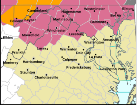
-

Junorch obs and discussion 2026
CT Valley Snowman replied to Damage In Tolland's topic in New England
A dissapointing 86 with the cloud cover but it was well modeled. Hoping for some good bangers later. -
2026 Mid-Atlantic Severe Storm General Discussion
SnowenOutThere replied to Kmlwx's topic in Mid Atlantic
Also PDS severe T-storm warning just north of Cumberland across the PA line. -
We did end up with a lot of sun here in Mattapoisett.. Up to 67*. Seasons in seasons.
-
2026 Mid-Atlantic Severe Storm General Discussion
SnowenOutThere replied to Kmlwx's topic in Mid Atlantic
SPC mesoanalysis shows 500+ (and increasing) CAPE, okay enough ML lapse rates, better LL lapse rates, and 30kt effective shear 0-6km all in the NOVA area. With a forward motion towards the metro of 35ish MPH and it being 100 miles away it should approach us by sundown. I think we could at least get a decent line of showers and storms with much needed rainfall. Maybe Harper's ferry and MD will get some nasty severe weather too. -
I zoomed in and see part of NYC included as well.
-
Watch just issued for my backyard
-
Looks quite good for some damaging winds later
-

2026 Mid-Atlantic Severe Storm General Discussion
high risk replied to Kmlwx's topic in Mid Atlantic
Nothing in the current or forecast parameters looks particular unfavorable, unless I’m missing something. I think that SPC agrees, given the inclusion of northern MD in the ENH area. -
Nam is finally on board
-

E PA/NJ/DE Summer 2026 Obs/Discussion
LVblizzard replied to PhiEaglesfan712's topic in Philadelphia Region
Well they just upgraded SE PA to an enhanced risk. 45% wind with a CIG1 hatched area. Radar out west looks pretty juicy…maybe we can get a good show later?


.thumb.JPG.418e8a9a2902ae687ec35ff4bc0e038e.JPG)


