All Activity
- Past hour
-
This is the 6th time this season I've had a severe thunderstorm watch and a flood watch combo. I had almost an inch during one of the events. No severe at all. Today is the day! Flood me! Blow a tree down on my truck! Anything lol. This clouds are starting to get a lifty look to them. I think the atmosphere is about to go off.
-
 Looks like anything substantial may miss just east. lol We shall see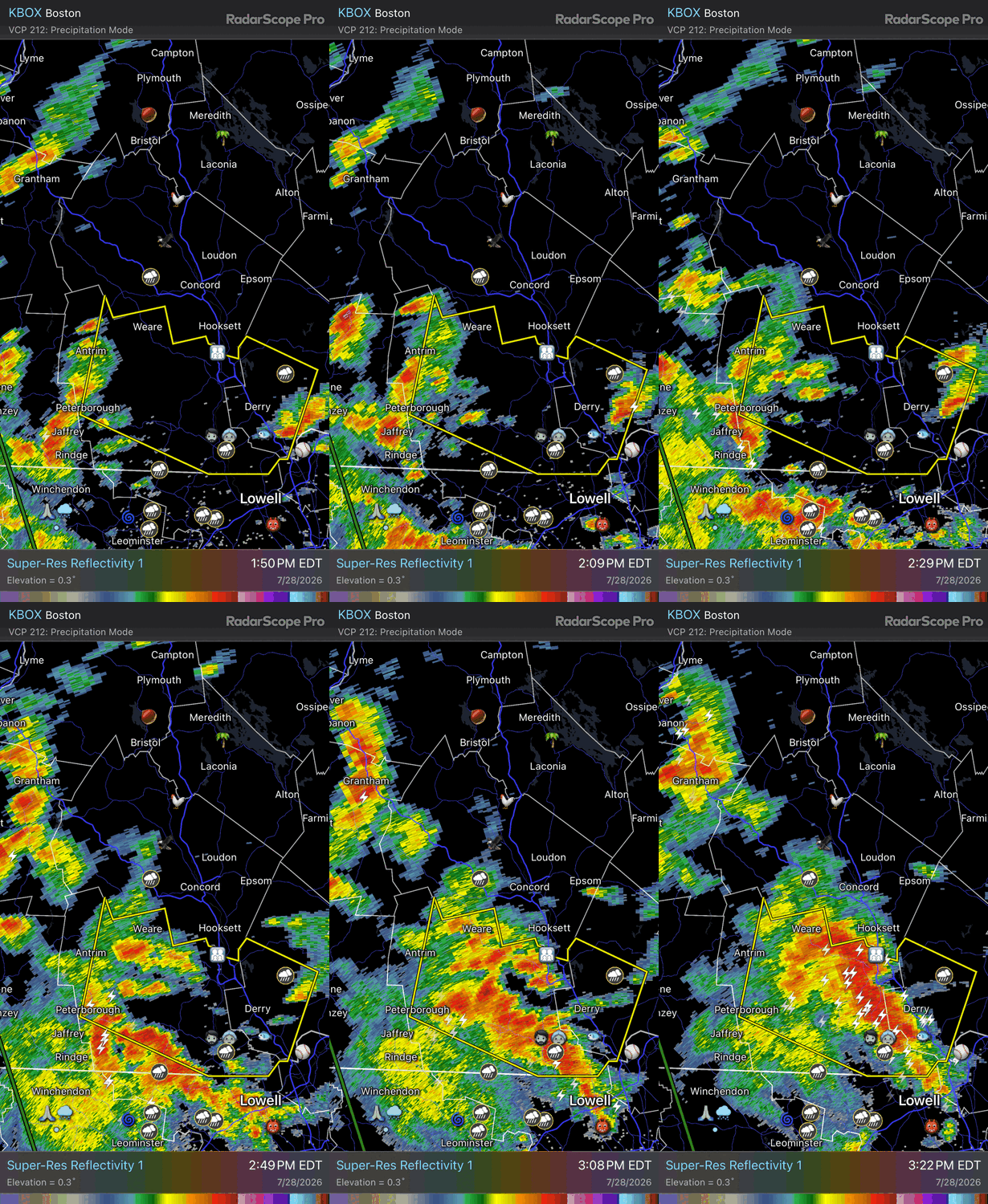
-
Real deal here in Chatham. Tremendous CTG strikes. Crashing thunder and torrential rain. Minimal wind.
-
warning for that one SVR from KOKX
-
Storms forming and more lightning activitiy to the far WNW. Clearing noted ahead of this area. https://www.star.nesdis.noaa.gov/GOES/sector_band.php?sat=G19§or=ne&band=EXTENT3&length=24
- 1,543 replies
-
- 1
-

-
- severe
- thunderstorms
- (and 7 more)
-
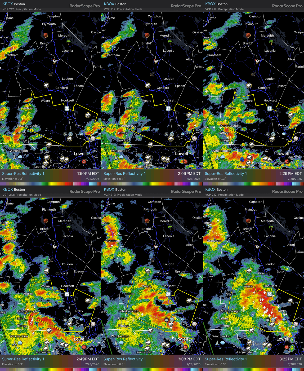
Certainly my mental radar extrapolation is we’re going to get a broad QLCS through the metro areas
- 1,543 replies
-
- 1
-
-
- severe
- thunderstorms
- (and 7 more)
-
Radar blowing up around Union as well. Im heading into it
-
90/71 at DCA ar 3pm... as @pazzo83 mentioned in the obs thread, thats warmer than forecast (looks like mid 80s was forecast)
-
I had over 2” of rain yesterday in 45 minutes and my office 10 miles away had nothing. This is what happens in these events. It doesn’t mean the storm busted.
-
high of 91F so far at DCA - well above forecast.
-
Yeah I'm on 22. Very dark that way
-
 0.5" in 20 minutes. Pretty impressive rates. That'd be 5" of snow.
 -
 wtf, we're going to get porked hard.
 -
we are still in the early innings of this event - you will get your storms and heavy rains eventually Mets called off their game for tonight in Queens
-
From my office in Berkeley Heights looks like the summit/short hills area getting crushed.
-
I see 18z HRRR hits our area pretty good around 10pm, but as you said who knows. The cell that popped up to the south that caused the current warning for Middlesex County will miss our area to the east. We might get through the afternoon with almost nothing here, but hopefully later tonight will deliver.
-

2026-2027 Super El Nino
snowman19 replied to Stormchaserchuck1's topic in Weather Forecasting and Discussion
Historic TC season in the PAC inbound thanks to El Niño, and these are just going to keep the WWBs in full swing…. -

2026-2027 Super El Nino
Stormchaserchuck1 replied to Stormchaserchuck1's topic in Weather Forecasting and Discussion
It was my first snowless Winter as a kid. Thankgoodness I didn't know about ENSO yet or I would have really realized the potential that could have been, especially with -NAO January. I think the AO will be more negative this coming Winter, which is good- widespread cold at times. -
I got the split in New Brunswick with storms to the N/W and now to the east. Happened yesterday too.
-
E PA/NJ/DE Summer 2026 Obs/Discussion
Albedoman replied to PhiEaglesfan712's topic in Philadelphia Region
starting to make a dent in the drought. Almost another inch of rain in thunderstorms in western Lehigh County this afternoon thus far.. -
2026-2027 Super El Nino
Stormchaserchuck1 replied to Stormchaserchuck1's topic in Weather Forecasting and Discussion
I was just mentioning that your analog composite of <-60dm for DJFM is probably too low. I used 6 straight months of -PNA as an example. That doesn't mean I expect the PNA to be negative, just that there are competing forces right now. -
BULLETIN - EAS ACTIVATION REQUESTED Tornado Warning National Weather Service Baltimore MD/Washington DC 310 PM EDT Tue Jul 28 2026 The National Weather Service in Sterling Virginia has issued a * Tornado Warning for... Southwestern Highland County in western Virginia... * Until 345 PM EDT. * At 310 PM EDT, a severe thunderstorm capable of producing a tornado was located near Burnsville, or 12 miles southwest of Monterey, moving southeast at 30 mph. HAZARD...Tornado and tennis ball size hail. SOURCE...Radar indicated rotation. IMPACT...For those in the direct path of a tornado touchdown, flying debris will be dangerous to those caught without shelter. Damage to roofs, siding, and windows may occur. Mobile homes may be damaged or destroyed. Tree damage is likely. * This tornadic thunderstorm will remain over mainly rural areas of southwestern Highland County, including the following locations... Williamsville and Bolar. PRECAUTIONARY/PREPAREDNESS ACTIONS... TAKE COVER NOW! Move to a basement or an interior room on the lowest floor of a sturdy building. Avoid windows. If you are outdoors, in a mobile home, or in a vehicle, move to the closest substantial shelter and protect yourself from flying debris. && LAT...LON 3831 7972 3820 7949 3819 7949 3818 7952 3820 7957 3822 7971 3825 7977 TIME...MOT...LOC 1910Z 315DEG 25KT 3825 7970 TORNADO...RADAR INDICATED MAX HAIL SIZE...2.50 IN
-
then why the warnings in Middlesex County ? Storms now training north from northern Monmouth trough eastern Middlesex
-
You’re still going to get a good soaking, just not the amounts further West.
-
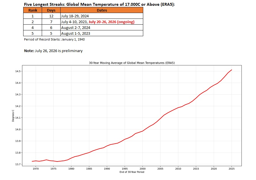
The global mean surface temperature has now been at or above 17.0°C for seven consecutive days. That is tied for the second longest such stretch. Such temperatures are a very recent phenomenon, first occurring in 2023 on the ERA5 dataset. The ERA5 dataset goes back to January 1, 1940.