All Activity
- Past hour
-
 TC ASW changed their profile photo
 -

December 2025 regional war/obs/disco thread
40/70 Benchmark replied to Torch Tiger's topic in New England
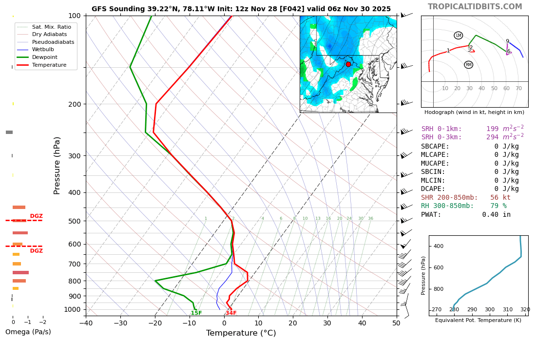
I largely ignore it and treat as an ensemble member...too much data as is. -
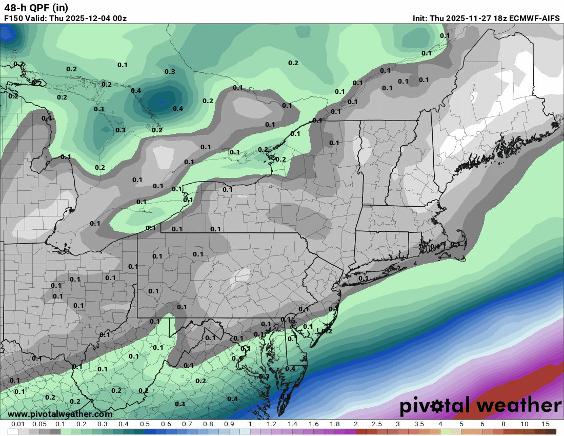
 Agreed. While it's possible the Newburgh waterfront on the Hudson is a slushy 33F vs. 32F and accumulating snow at Stewart airport, the model soundings say elevation along the transition zone might only matter in terms of rain vs. ZR.
 -

December 2025 regional war/obs/disco thread
weatherwiz replied to Torch Tiger's topic in New England
That AI model stuff is such a waste of resources. But some storm will happen that an AI run "nailed at D10" (even though it jumped around a million times inbetween) and parades are being conducted and research papers flying saying "AI is the next thing". -
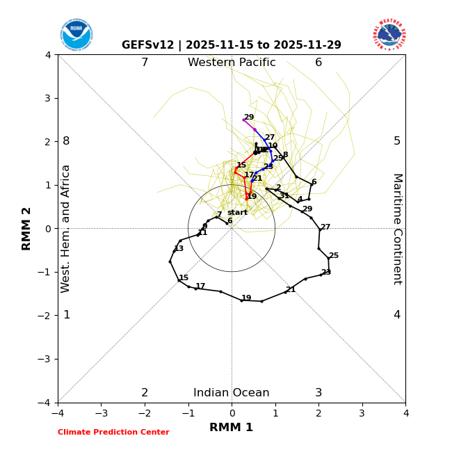
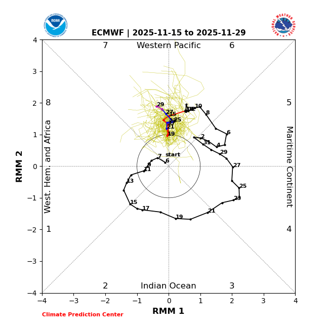
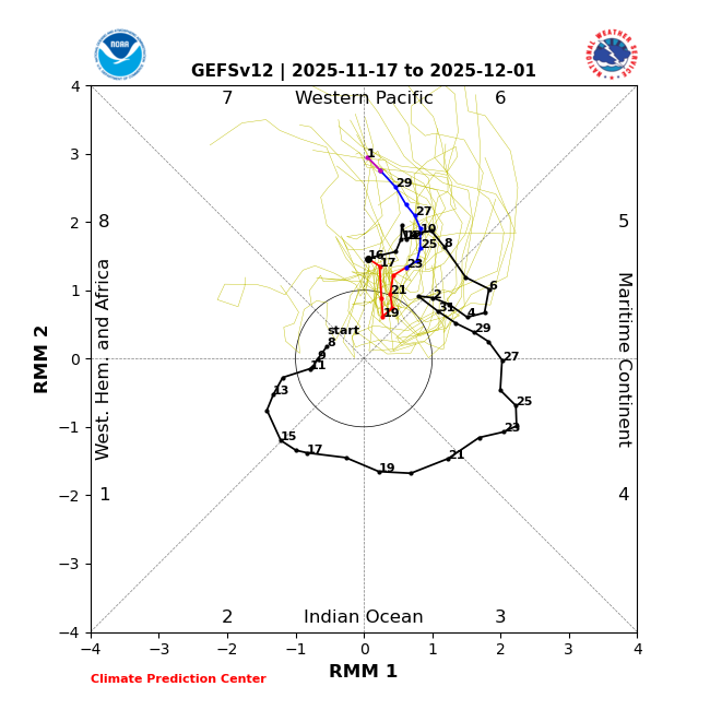
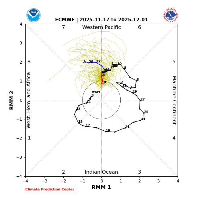
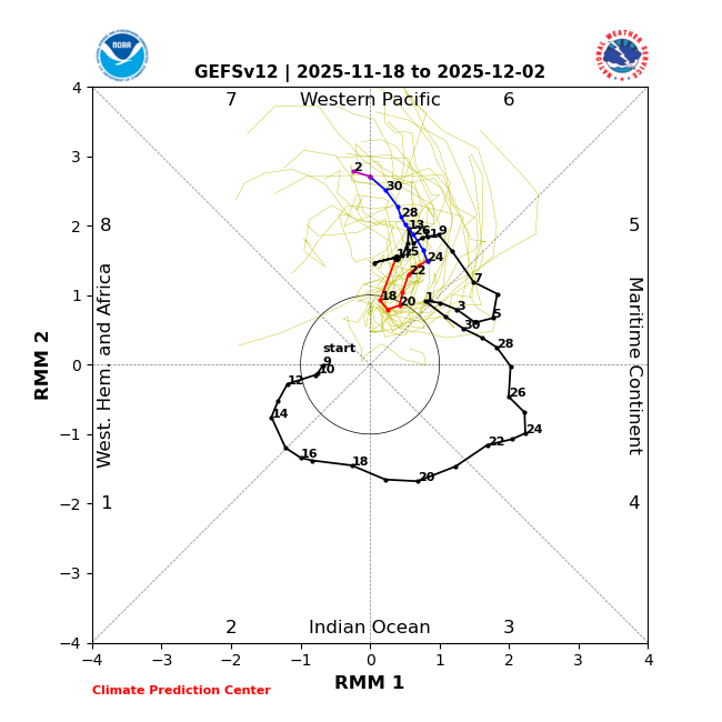
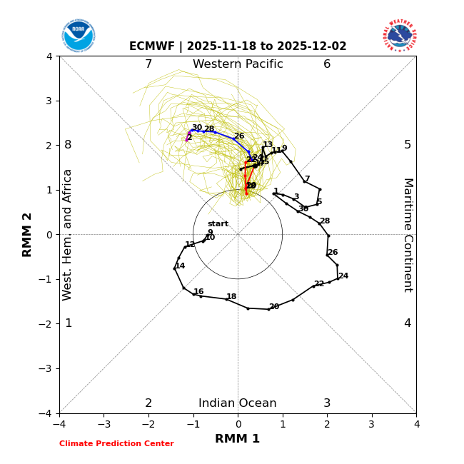
Indeed, after doing poorly with phase 6, the EPS absolutely was doing much better than GEFS getting into phase 7 between the 11/15 and 11/18 runs: 11/15 EPS: poor for 6; much better for getting into 7 11/15 GEFS: great for 6 but bad for getting into 7 (way too slow as 7 actually started on 11/27): Similar comparisons for 11/17-8 runs: 11/17 EPS: almost spot on with 11/27 ph 7 timing: 11/17 GEFS: still not in 7 on 12/1 11/18 EPS: great with ph 7 11/18 GEFS: not into phase 7 til 12/2, 5 days too late
-

Nov 28-30th Post Turkey Day Wintry Potential
hawkeye_wx replied to Chicago Storm's topic in Lakes/Ohio Valley
12z Euro... doesn't get much better for Iowa.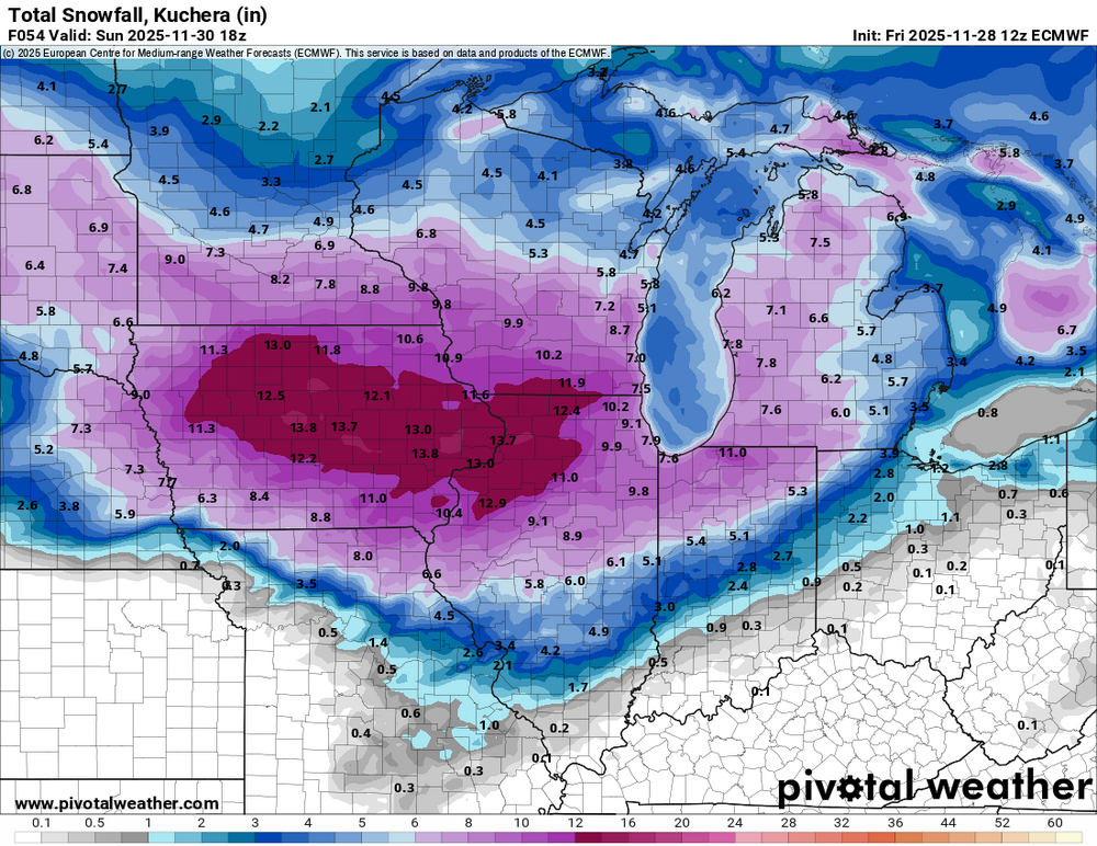
-
What a cute model

-
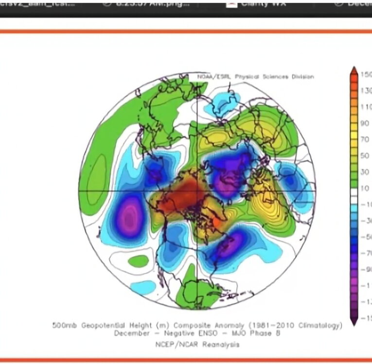
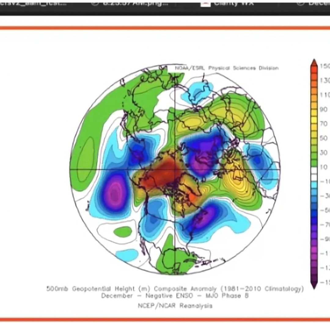
Walker circulation and yes. It’s why relative ONI (RONI) is used frequently here, because the eastern equatorial pacific warming relatively slower than the rest of the pacific is amplifying La Niña and also weakens the signal of El Niño to some extent. Walker circulation: https://www.climate.gov/news-features/blogs/enso/walker-circulation-ensos-atmospheric-buddy
-

E PA/NJ/DE Autumn 2025 Obs/Discussion
RedSky replied to PhiEaglesfan712's topic in Philadelphia Region
It's the offensive line -

Nov 28-30th Post Turkey Day Wintry Potential
SchaumburgStormer replied to Chicago Storm's topic in Lakes/Ohio Valley
For old times sake, SREF plume has me at 9.5” with a number of higher members and nothing below 7”. Locked in. -
December 2025 regional war/obs/disco thread
40/70 Benchmark replied to Torch Tiger's topic in New England
+SDC would def work better for my area on the GFS, I think....like 3-4". -
As opposed to the brutal 4-5-6 response from last year?
-
At least 12z Euro AI gets precip into interior SNE now.
-
December 2025 regional war/obs/disco thread
40/70 Benchmark replied to Torch Tiger's topic in New England
The GFS gradient is like 5" at KLWN and 10" IMBY lol Nuts. -
Dont sleep on that little burst tomorrow night out this way.

-

Nov 28-30th Post Turkey Day Wintry Potential
IWXwx replied to Chicago Storm's topic in Lakes/Ohio Valley
Crossing my fingers too. I saw your call and if it is onto something, you might have to bring your totals down a little, especially to the south and I would that for you (and me lol). But at least you have warned the public about possible last minute changes since we are riding the edge. So far IWX and you are in pretty good agreement though. -
Hard to lock anything beyond 72hrs now, sometimes not even a lock inside that anymore. The struggle is real.
-

Nov 28-30th Post Turkey Day Wintry Potential
Radtechwxman replied to Chicago Storm's topic in Lakes/Ohio Valley
Yeah the early morning through mid to possibly late afternoon look good here. Probably several hours of solid rates. But I would be shocked with a low track that north if we dont mix or switchover at some point. But good thing is here looks to happen towards end of the event when most of our accumulation is done already. This system doesn't have much of a deformation zone. -

2025-2026 Fall/Winter Mountain Thread
ncjoaquin replied to Buckethead's topic in Southeastern States
Welcome! -
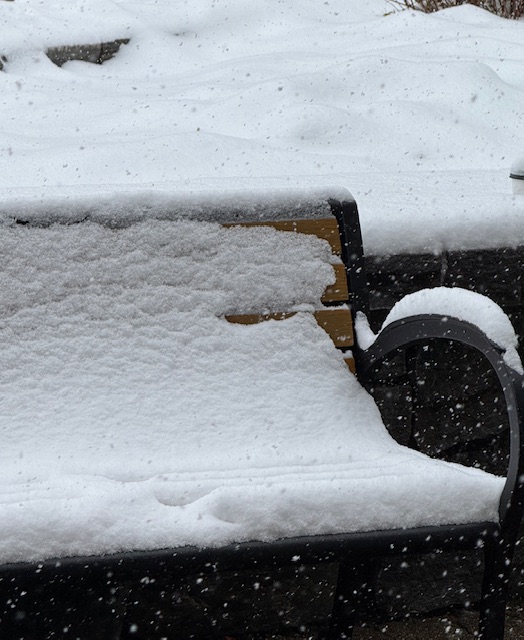
4” overnight plus today? Must be a sweet powder day. Its been snowing for a couple hours (1”/hr) and about 2” new today after 1” overnight. This is accumulations since about 9-10am in the base area.
-
Agree it looks good right now, but too close. I'm comfy betting on a NW trend at day 4 in early Dec that depends on a cf penetrating into warmish ocean water and a baroclinic zone setting up offshore or near shore.
-

December 2025 regional war/obs/disco thread
H2Otown_WX replied to Torch Tiger's topic in New England
What are the temps like? -

December 2025 Short/Medium Range Forecast Thread
GBOVolz replied to John1122's topic in Tennessee Valley
PowellVols is in. Had to start a new account, new email . -

2025-2026 Fall/Winter Mountain Thread
Maggie Valley Steve replied to Buckethead's topic in Southeastern States
Welcome! Glad to have you in our great group of Mountain posters! May there be many 'Jebwalks' in your future! -
I'm betting he's at least 75% snow in this...probably all snow. Even the zonked GFS is like right on the line for him to be mostly snow.
-
GBOVolz changed their profile photo
-
Yep break out the shorts