All Activity
- Past hour
-
.thumb.jpg.6a4895b2a43f87359e4e7d04a6fa0d14.jpg)
Central PA Spring 2026 Discussion/Obs Thread
Yardstickgozinya replied to Voyager's topic in Upstate New York/Pennsylvania
I don't to basically post a double map, so I thought I'd add spc's discussion for tomorrow to your post. https://www.spc.noaa.gov/products/outlook/day2otlk.html -
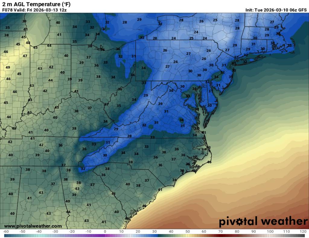
Lows in the 20s for a lot of us Friday morning. Actually temps will be probably be in range of 35 to 45 degrees for a high Thursday. That could be some 35 to 40 degrees temp change in 24 hours. Sent from my SM-G998U using Tapatalk

-
Speaking of one extreme to the next. This is as extreme as you can get. 90 1 day and possible flakes the next. Sent from my SM-G998U using Tapatalk
.thumb.jpg.11f002d39b5e5e8b5fe9b29dc4935b29.jpg)
-
Central PA Spring 2026 Discussion/Obs Thread
Yardstickgozinya replied to Voyager's topic in Upstate New York/Pennsylvania
Why did , your map chang? This isn't the one that you posted. -
Lost my net last Friday aftrn. Outage in my area with Frontier. Finally came back during the overnight last night. Picked up 1.2" of snow last night as well.
-
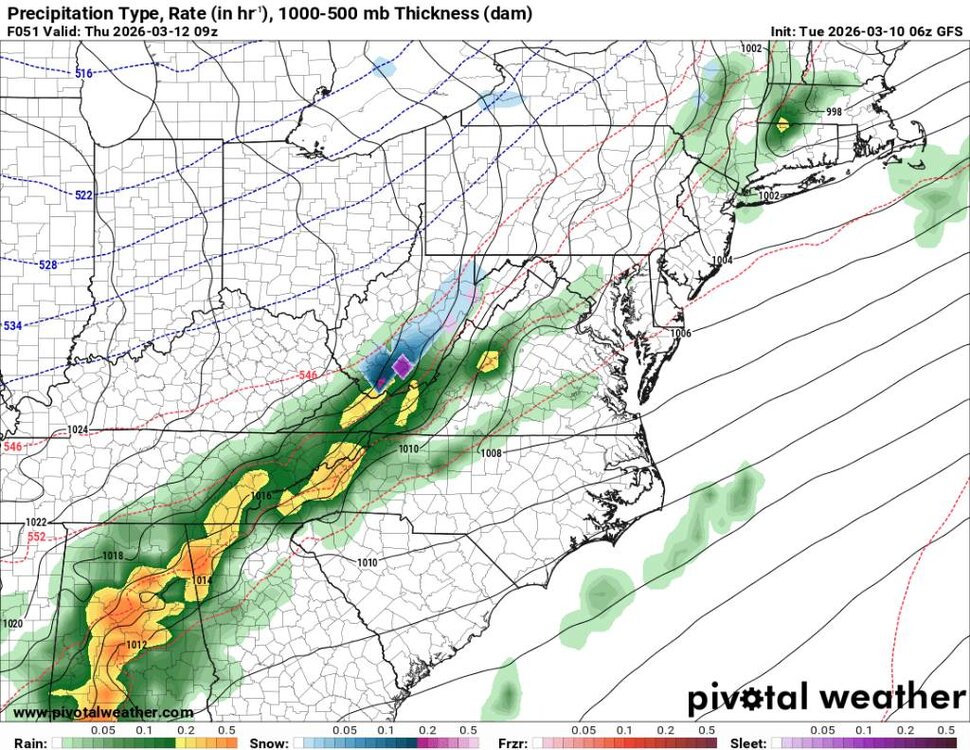
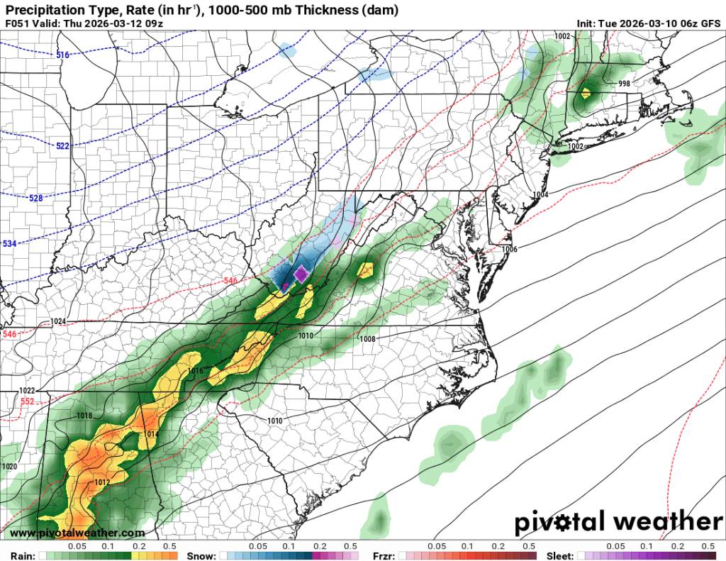
Still looking like we go from storms to possibly some flakes Thursday in the high terrain. Sent from my SM-G998U using Tapatalk
.thumb.jpg.5b4f280946967e25b8d3cc398bd01b19.jpg)
-
00z Euro has a line of boomers followed by a cold shot till mid week before warming up. We can endure that. .
-
I wonder if the old folks are going to head to the basement for the 10am test Might be a confusing day for some
-
Central PA Spring 2026 Discussion/Obs Thread
Yardstickgozinya replied to Voyager's topic in Upstate New York/Pennsylvania
My Son and his budy from work had some luck the past two days on the Conawago West and the Susqy fishing from shore. I saw a few boats out today Lake Frederick Goldsborough area hitting in the mouths of the creeks.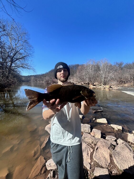


-
Think of how nice it will be when we’re all uniformly 75/74 soon.
-
Yeah 25+ degree inversion today in like 700-800 feet. That's a hell of an inverse lapse rate. Is thunderfog a thing?
-
It legit was warm . Drenched in sweat. What was cool was you could feel the cold air coming off the remaining snowpack as the wind blew but was warm when you weren’t near the snow
-
Amazing difference between the hills and the valleys. 31 for a low here and 28 at IJD.
-
Up here in northeast Michigan I could see a "severe" ice storm tonight and tomorrow. Can someone please post the FRAM forecasts? Thanks
-
ready for some stones
-
Low of 26°.
-
Where is Ginxy’s biggun?
-
SPF 70 is already installed.
-
Oh ok (morning AFD from LWX) KEY MESSAGE 2...Severe thunderstorms are possible Wednesday afternoon and evening as a strong cold front pushes through; a significant drop in temperatures and gusty winds will accompany the front Thursday. A deep, digging, positively northern stream trough and its associated strong cold front dive out of the Great Lakes Wednesday. The cold front crosses the area late Wednesday night into Thursday morning. Meanwhile, southern stream energy will be lifting northward ahead of the boundary Wednesday afternoon and evening. All of this creates a very complex severe weather setup across the region. The latest update from the Storm Prediction Center expanded the Slight Risk (level 2 out of 5) to include most of the area. However, it does come with some caveats, which I`ll reiterate here. Primary among them is the question of ongoing morning showers/convection, and the potential impact that could have no destabilization during the afternoon. As is typical, model guidance is very split on how much instability is able to recover ahead of the pre-frontal trough that will be the primary severe threat on the day. I do think that seeing the latest CAM guidance in favor of 750-1250 J/kg of CAPE being able to develop has me a bit more concerned. Assuming that we do get adequate CAPE, storms will fire along a pre-frontal trough during the early afternoon hours across eastern WV before moving east towards the metros during the evening. The environment where storms may develop will be impressive from a shear standpoint, with 40-50 kts of deep-layer shear, and substantial amounts of Storm Relative Helicity (150+ m2/s2 0-1km, and 400+ m2/s2 in the 0-3 km layer). This is more than favorable for supercell structures to develop, with damaging winds, large hail, and even a tornado or two not out of the question. Looking at the combination of shear and instability, the STP is actually pretty impressive in model guidance. For this reason, there is actually a CIG1 hatched area in our 2-5% tornado probabilities across western MD and into the Potomac Highlands. I wouldn`t even argue having with having that threat even extended a bit further east along the MD/PA border in a future update, but will let the 12z CAMs and machine learning guidance come in for evaluation. Additionally, damaging winds, large hail, and heavy rainfall will all be threats with any storms that develop on Wednesday afternoon. At any rate, Wednesday afternoon/evening is a day to watch closely. Have your severe weather plans ready, in case you find yourself needing to act on them. Continue to monitor the latest forecasts from our office, as well as the Storm Prediction Center, for the latest updates. Confidence drops off significantly with the severe threat along the immediate cold front given the projected timing late evening into the overnight period. Even with that said, a gusty line of showers could exist Wednesday night into Thursday as the front pushes through. Would expect this to be more along the lines of a gusty surge along the front (30-40 mph), followed by increased synoptic winds shortly thereafter.
- 34 replies
-
- 1
-

-
- severe
- thunderstorms
- (and 7 more)
-
31.7°
- Today
-
Stayed above freezing overnight. 34F. Bit o fog to burn off this AM.
-
Yesterday was very warm but dewless. Today we have both. KO coming for the pack.
-
Many of the big snow piles melted up here. Now large pieces of broken curbs are being exposed that were plowed up under the snow. So we are going to need new curbs and pothole repair since the roads are in very rough shape. Also big piles of mud where the snow was as chunks of lawns were caught up in the plows. Hopefully we can get some more rain this summer as the grass went brown pretty quick last summer with the record heat and lack of rainfall. Reservoirs got recharged a bit this winter as they dropped to low levels here at times since September 2024.
-
Low- mid 70’s today. The tanning will be intense
-
Good luck to all next door. All I can hope for is a stray pre frontal cap breaker in the late afternoon through evening. Think there will be more nighttime action than anyone desires. Gonna be 12 hours or so of twilight through the dark hours for a potential long tracker to run out ahead. Keep those weather radios and radars cranking. Only good thing is storm motion doesn't look to be typical early Spring speedsters. These will be full on SUPS hard anchored into the BL if/when they blow up before getting messy as they move East.

.jpg.8f64275c318b8fefb96d92eadb60dadc.jpg)
.jpg.e57f1d9c124923964fc5fd294d790283.jpg)


.thumb.png.4150b06c63a21f61052e47a612bf1818.png)


