All Activity
- Past hour
-
It reminds me of the one the models all had earlier this month. The models and the forecast had several days in the mid 90s here just a few days before and we ended up in the low 80s with some of those days in the 70s. That was actually a huge heat bust. Let's see if this one comes to fruition.
-
Ian whats up???
-
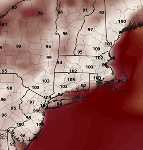
850s are probably 1-2C overdone since it’s mixing above that level. Still, MEX has b2b 100s at LGA, 102 at BDL, and 101 at FIT. This is BOS metro Wed afternoon. I think it will mix out some with weak W flow, but I don’t think it’s exotic enough to pull off exotic records. I’m leaning 98-100 in the hot spots for now. Maybe someone gets a lucky 101°. Mid 60s afternoon dews with low 70s with the evening and morning spikes
-
I wonder what the cause of that could be
-

Pittsburgh PA Summer 2026 Thread
Ahoff replied to TheClimateChanger's topic in Upstate New York/Pennsylvania
Accuweather pulled the trigger and forecasts 100 for KPIT on Wednesday. That would be the earliest 100 degree day ever in Pittsburgh. However, their forecast looks way too hot overall. -
47-48 was around normal in Dec, cold and very snowy in Jan, AN in Feb. The cold wasn't extreme (nothing below -6) in January but persistent and it was around -7 for the month with 18 inches of snow here. 75-76 were similar but with about half the total snow here. Dec was around -2.5, January was around -5, Feb was AN but the biggest snow event was in Feb. January had a two decent snow events on the Plateau (3.5 and 5 inches), up into Pennington Gap/Wise, Va, that don't appear to have been much of anything outside of the Cumberland Mountain region. That led to 4 different mornings of below zero weather for here, Oneida, and Wise. Snow fell on 14 different days in the month in other areas but it was T to .5 inch amounts and lowest bottomed out around 1-3 in most of the area.
-

2026-2027 Super El Nino
roardog replied to Stormchaserchuck1's topic in Weather Forecasting and Discussion
I always thought a true Modoki or west based El Nino had 1+2 below Nino threshold or even negative. I recall discussion on that here sometime in the past when Bastardi would call any Nino with 1+2 having a lower anomaly than 4 a Modoki and people would say that is incorrect. So wouldn't the same apply to an east based Nino just opposite? 1997 at this time had a true east based Nino IMO with region 4 at 0.1. If having the entire Nino basin be above 0.5 isn't basin wide then I guess I don't even know what is. -

E PA/NJ/DE Summer 2026 Obs/Discussion
Birds~69 replied to PhiEaglesfan712's topic in Philadelphia Region
Really not a bad day besides the DP. Cloudy, shower here and there and in temps in the 70s... 74F/DP 68F -
As always, it ain't the heat, its the Dew's. Sorry, had to lol
-
I don't recall seeing the MEX be 101 at KFIT over 96 hours away. That's about 20 over climo at range when it's weighted too. 102 at BDL! 98+ ASH/MHT.
-
There have been huge gaps in terms of weather balloon coverage - basically the entire mountain west lacked coverage for the 12z runs today. This is obviously impacting model forecasts at this point.
-

2026-2027 Super El Nino
LakePaste25 replied to Stormchaserchuck1's topic in Weather Forecasting and Discussion
One key characteristic of an east based event is the thermocline has an even or even slightly downward slope from W to E which is what tends to shut down MC convection. Still sloping the other way although you can see may have turned the corner out near 120E. We will see if this propagates across or not. Even if this is east based, I am going to say the same thing which is mostly above normal winter with windows of opportunity for a KU event.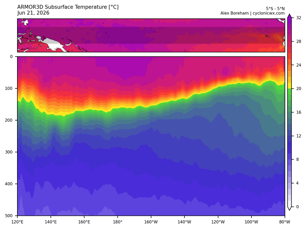
-
New Years eve was a historic ice storm in West and Cen Tn,but that was a nuetral ENSO i believe ,also75-76 was basically NINA as well,just saying
-
It's been that way for like a year now. If they haven't caught on by now I don't think there's any hope. Every one of the CPC lookahead precip charts shows above normal precip over the entire area yet their drought map shows that drought "persists" (doesn't "remain but improve"). They're covered no matter what happens I guess.
-

2026-2027 Super El Nino
40/70 Benchmark replied to Stormchaserchuck1's topic in Weather Forecasting and Discussion
I am willing to bet @snowman19 $100 we see a NESIS level storm on the east coast during the coming season....should be "easy" money for you, right? 'Cmon....I'll hook you up- -
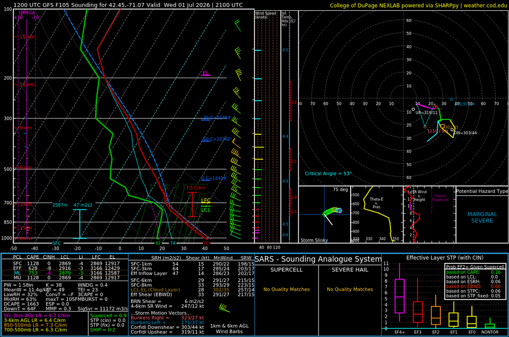
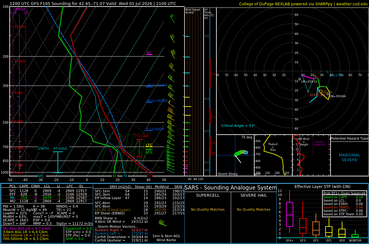
This is 105 hours away ... above 80 percentile confidence for a heat wave in general, and here... we're banging 2-meter temperatures like this: Granted, the GFS tends to over mix but... I dunno in the case. Brian, any opinion? From what I am seeing ... the synoptic parametric constraints actually support something extraordinary here. Sorry if that "hyperbole" offends a few self appointed rhetoric police, but it is unfortunately for those officers objectively true. +23-25c 850 W to WNW light d-slope oriented compression flow type < 50% RH at typical ceiling sigma levels during the 12z to 21z interval(s), Wed and Thurs We will have 0 problem mixing probably to the 825 mb level for that matter... A the pure adiabat from a 25c 850 is ~ 40c at 1000mb. 23c is 38 and a half. And these are not continuing the curve into the 2-m right slope where is going to be warmer in that sfc contact layer.
-

Central PA Summer 2026 Discussion/Obs Thread
Voyager replied to Voyager's topic in Upstate New York/Pennsylvania
What an f'n miserable day. I haven't felt good, physically or mentally, for the past 6 months, and needed a nice day out. Instead mother nature, or God, or whomever, doubled down and just made things worse. I just can't seem to win anymore... -
2026-2027 Super El Nino
40/70 Benchmark replied to Stormchaserchuck1's topic in Weather Forecasting and Discussion
I think you need to keep an open-mind, as I tried to tell you last year at this time when you kept preaching about "canonical-front loaded La Niña". We all make mistakes, as lord knows I have (see 2015, 2018, 2019 and 2023), but the hope is that each mistake pries the mind open a little more and causes us to be more exhaustive in our approach, and less dismissive and derogatory towards alternative points of view. Latest anomalies from east (1.2) to west (4) 2026 17JUN2026 26.1 3.0 28.5 1.9 29.3 1.7 30.2 1.3 2023 14JUN2023 25.9 2.7 27.8 1.2 28.6 0.9 29.5 0.6 2015 17JUN2015 25.1 2.0 28.0 1.5 28.7 1.1 29.7 0.8 1997 18JUN1997 25.8 2.7 27.8 1.3 28.5 0.9 29.0 0.1 Sure looks basin-wide to me, and is forecast to remain as such. -
Gfs 100+ Thursday! Let's get those heat indexes through the roof!
-

Central PA Summer 2026 Discussion/Obs Thread
Jns2183 replied to Voyager's topic in Upstate New York/Pennsylvania
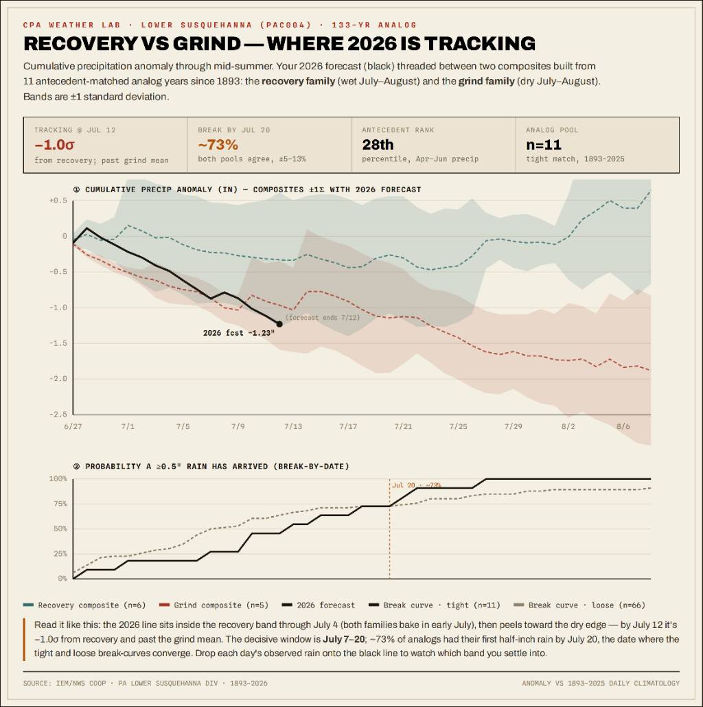
This is a PAC004 Lower Susquehanna analog monitor using 133 years of data. The analogs split into two camps: recovery years, where a real July/August rain break arrived, and grind years, where the pattern stayed dry enough that small rains failed to reset the soil. Recovery camp: 1898, 1900, 1921, 1934, 2010, 2024. Grind camp: 1913, 1944, 1964, 1966, 1999. The 2026 line starts inside the recovery envelope, but by July 12 it peels toward the dry edge, about -1.0σ from recovery and past the grind mean. The key window is July 7–20. Around 73% of analogs had their first half-inch rain by July 20. So this is not a locked-in drought verdict yet, but the current track is leaning grind unless we get a meaningful half-inch-plus rain event by mid-July. Sent from my SM-S731U using Tapatalk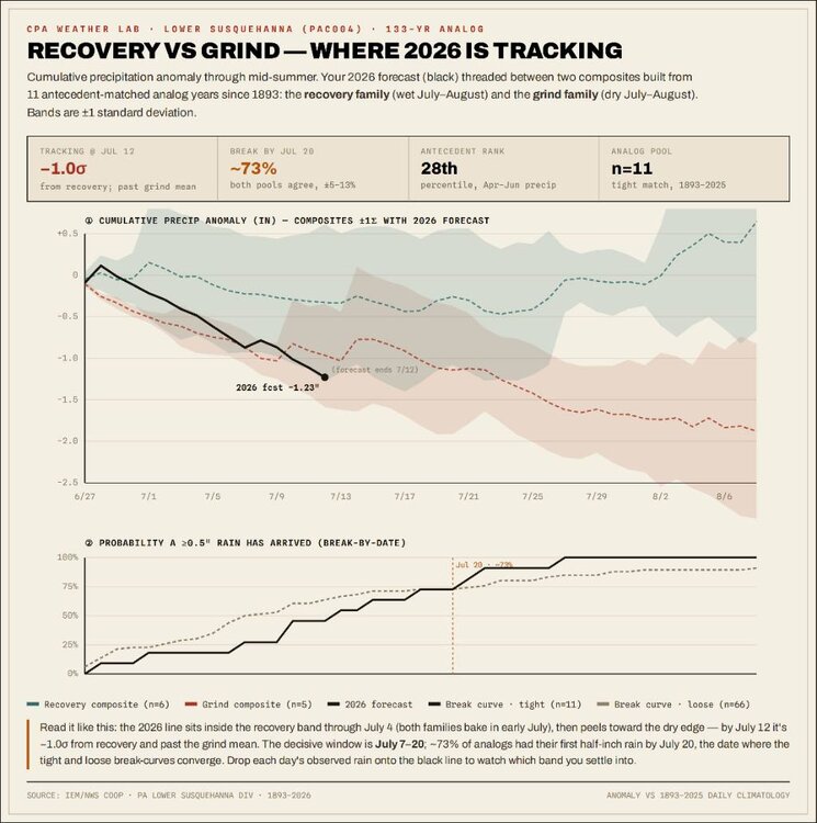
-
Forecasters need to catch on that rain events are not being realized. It’s called pattern recognition. Friday afternoon was forecasted as a 90% Rainer into and thru Saturday and so far barely more than Zero
-
Seems like the only thing that verifies in the long range nowadays is a heat wave...
-
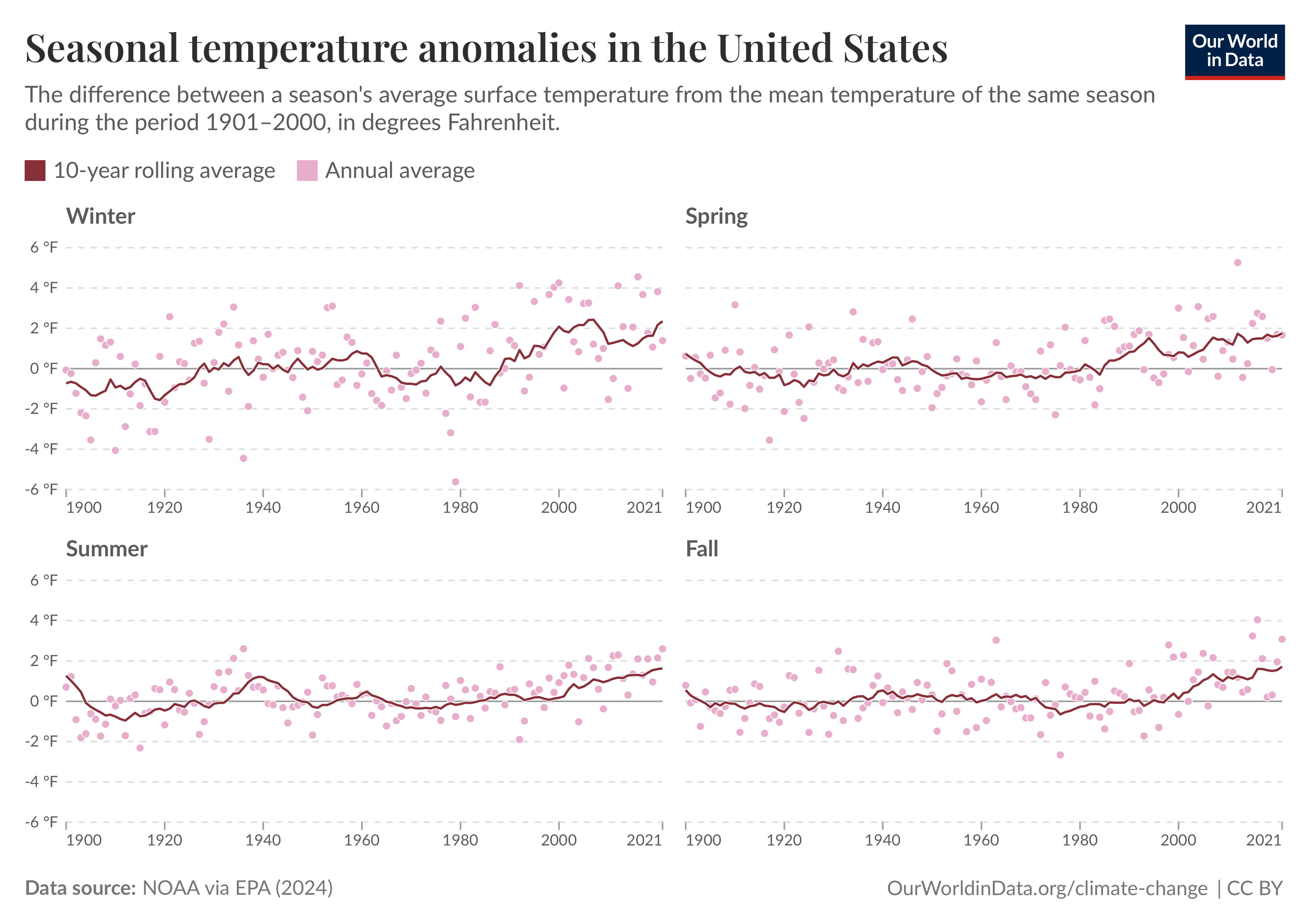
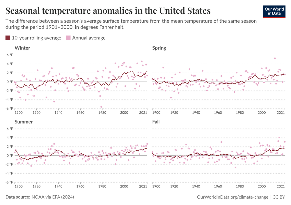
" Heat Wave Days" vs. Temperature anomalies broken out by seasons. Trend lines are similar- rising steadily as a whole.
-
2026-2027 Super El Nino
roardog replied to Stormchaserchuck1's topic in Weather Forecasting and Discussion
Aren't all the nino regions currently above the .5 threshold? -
GFS was ticket warmer even (12z) in the complexion of that


.thumb.gif.f92b16c631a1d15d405ed77b33f0710d.gif)