All Activity
- Past hour
-

2025-2026 ENSO
donsutherland1 replied to 40/70 Benchmark's topic in Weather Forecasting and Discussion
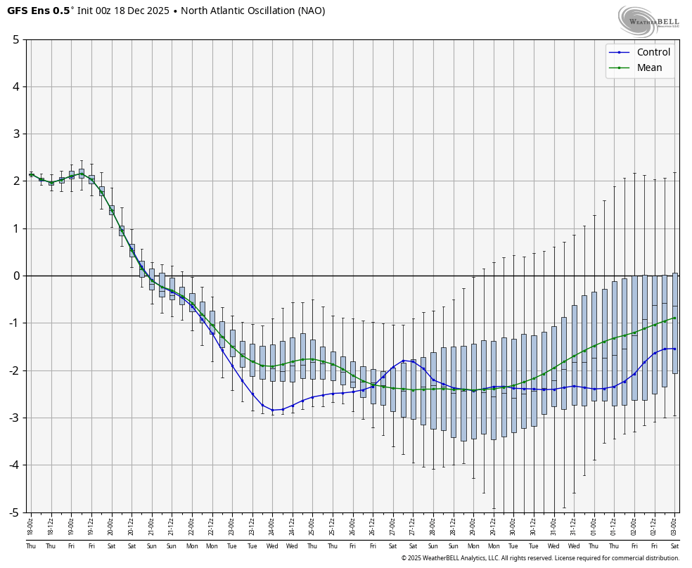
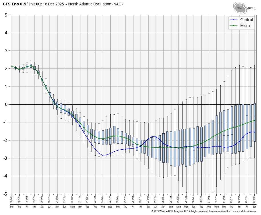
While the AO and NAO are looking good on the latest GEFS, the PNA is not.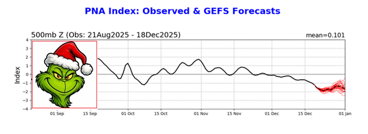
-
Feels like spring storms should be on the way.
-
I was just going to post that. It's a little better but I'm not sure about big storms.
-

-
-
Today’s progged highs will easily be exceeded. Upper 40’s in view for many.
-
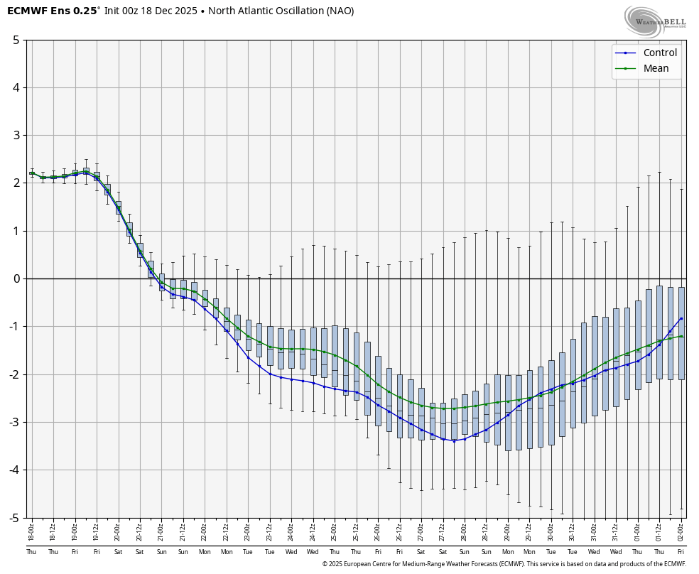
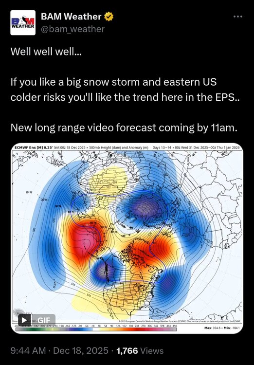
NAO keeps getting stronger on EPS

-
I think part of what helped December, 2010 was El Nino “hangover” from the very healthy Nino the winter before, so you still had some semblance of a southern stream/STJ around at that point
-
The -NAO continues to be very strong for late this month per the 0Z GEFS and EPS:

-
I feel like "winter is canceled" posts based on one day 15 run of an op followed by days of models showing winter is not canceled should yield a one-month ban for those making such posts...
-
140% of climo…meh.
-
Time to watch is the rising back up after 12/28.
-

December 2025 Short/Medium Range Forecast Thread
Golf757075 replied to John1122's topic in Tennessee Valley
Carver, I wished the aleutian ridge would retrograde or shift east and morph into a Alaskan ridge. Alot of ebbs and flows for sure. A guy who is a friend of mine on Facebook, which he does a weather page. He mentioned that the farmers almanac shows a winter storm first week in January for mid south/ tennessee valley. That would be interesting because we had one last January around same time. I think unless the nao goes west based, it will benefit east of us, but we shall see. Another case of if the nao will be able to morph from east to west based. -
Am I right that, if there were not an inversion, and we had the right setup (like warm LOL), this would be interesting?

-
For all this model stuff being nice to see, proof is in the pudding. Lets see if/when it happens and then maybe the models will start to sniff out threats
-

December 2025 regional war/obs/disco thread
WinterWolf replied to Torch Tiger's topic in New England
I don’t know Ray…it’s close but that period from 85-92 was absolutely horrid too. If this season sucks…it would be close imo, but I still think we’d need another one on top Of this to be even with that 85-92 stretch here. Let’s hope we don’t have to go there. -

December 2025 regional war/obs/disco thread
40/70 Benchmark replied to Torch Tiger's topic in New England
Just hit the + sign instead of quote, and you can gather as many as you would like. -
2025-2026 ENSO
donsutherland1 replied to 40/70 Benchmark's topic in Weather Forecasting and Discussion
In general, a PNA- pattern results in lighter snowfalls in the New York City area and northern Mid-Atlantic. The Boxing Day blizzard is a notable exception and the only KU snowstorm during December when the PNA was negative. -
December 2025 regional war/obs/disco thread
WinterWolf replied to Torch Tiger's topic in New England
I’m on Mobil all the time…and I see everybody’s avatar/picture..or whatever you call them. -
-
This morning, the low temperature at Central Park was 36° while the lows at Bridgeport and White Plains were 24° and 25° respectively. That is the largest difference in low temperatures between Central Park and Bridgeport and Central Park and White Plains this month. The last time these differences were matched or exceeded was November 25, 2025 when Central Park had a low of 46°, Bridgeport had a low of 34°, and White Plains had a low of 35°.
-
Not good for much more than a light snowfall
-

December 2025 regional war/obs/disco thread
HoarfrostHubb replied to Torch Tiger's topic in New England
Well... I just deleted it... Funny how I forget things like that -
115” of meh.
-

Central PA Winter 25/26 Discussion and Obs
pasnownut replied to MAG5035's topic in Upstate New York/Pennsylvania
tomorrow Santa is doing his "north loop" to Lock Haven, Susquehanna, and Bloom universities. I picked a gem of a day to do it.